
High tides bring coastal flood alerts to California
A Coastal Flood Warning remains in effect for the San Diego and Orange County coasts through October 29, 2026, as high tides and elevated water levels threaten roads and low-lying property. The National Weather Service (NWS) also has Coastal Flood Advisories for other shoreline areas, including Los Angeles-area beaches, San Francisco Bay, Monterey Bay and Humboldt Bay.
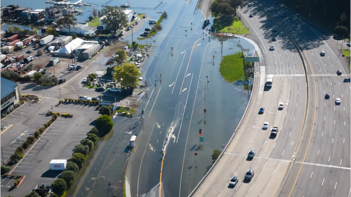
Image credit: California King Tides Project
Coastal flood alerts remain in effect across the San Diego, Los Angeles/Oxnard and San Francisco forecast areas through Thursday, October 29. The National Weather Service (NWS) has a Coastal Flood Warning for San Diego and Orange counties and Coastal Flood Advisories farther north, with high tides and elevated coastal water levels forecast to flood vulnerable low-lying locations and contribute to shoreline erosion and road closures.
NWS San Diego forecasts tides around 0.3–0.52 m (1–1.7 feet) above astronomical predictions in its warning area. NWS Los Angeles/Oxnard expects late-morning high tides of 2.29–2.44 m (7.5–8 feet), referenced to Mean Lower Low Water (MLLW), about 0.3–0.46 m (1–1.5 feet) above astronomical projections. In the San Francisco forecast area, the San Francisco tidal gauge is forecast to reach as much as 0.58 m (1.9 feet) above normal, with the predictions incorporating up to 0.3 m (1 foot) of surge.
Southern California
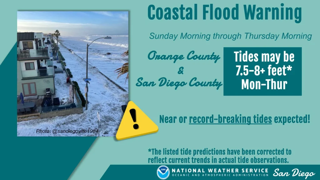
The warning for San Diego and Orange counties runs through 13:00 PDT (20:00 UTC) on October 29, with flooding expected around morning high tides. NWS forecasts water levels about 0.3–0.52 m (1–1.7 feet) above astronomical tide predictions.
The agency expects significant coastal flooding that could inundate vulnerable homes, businesses and critical infrastructure, close numerous roads and erode shorelines. NWS San Diego said flooding was expected even though surf was not forecast to be elevated.
Farther north, a Coastal Flood Advisory covers the coasts of Los Angeles, Ventura, Santa Barbara and San Luis Obispo counties, including Malibu, along with Catalina and the Santa Barbara Islands. It continues through 13:00 PDT (20:00 UTC) on October 29.
NWS Los Angeles/Oxnard forecasts minor to moderate seawater flooding around high tide, affecting vulnerable beach parking lots, bike paths and harbor walkways. Moderate to significant beach erosion is likely, with isolated structural damage possible in the most exposed locations.
Late-morning high tides are forecast at 2.29–2.44 m (7.5–8 feet) above Mean Lower Low Water (MLLW), around 0.3–0.46 m (1–1.5 feet) above astronomical projections. The highest tides are expected October 26–28, with a small chance of isolated Coastal Flood Warnings on October 28–29 if larger surf develops.
MLLW is a local tidal reference based on the long-term average of each day’s lower low tide. A water level measured above MLLW is not the depth of flooding above the ground.
San Francisco Bay and central coast
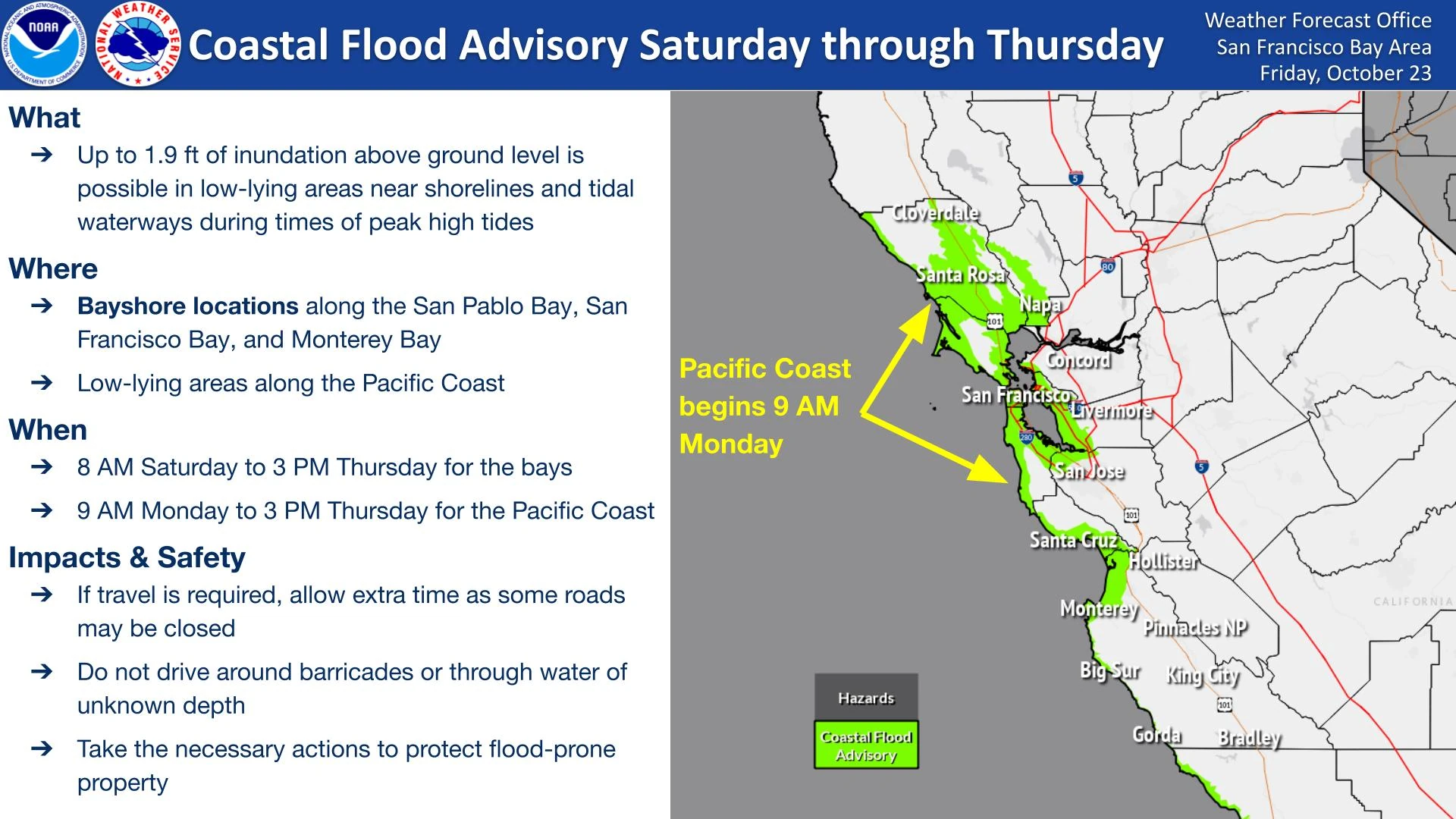
A Coastal Flood Advisory covers shoreline areas around San Pablo, San Francisco and Monterey bays through 15:00 PDT (22:00 UTC) on October 29. A separate segment covers the Coastal North Bay, including Point Reyes National Seashore, and the San Francisco Peninsula coast from 09:00 PDT (16:00 UTC) on October 26 through the same end time.
NWS forecasts up to 0.58 m (1.9 feet) of inundation above ground in vulnerable low-lying shoreline and tidal-waterway areas. Possible effects include flooding of infrastructure, isolated road closures, erosion and reduced access from beaches as water rises.
The San Francisco tide-gauge forecast:
| Date | High tide, PDT (UTC) | Water level above MLLW | Departure above normal stated by NWS |
|---|---|---|---|
| October 26 | 11:39 (18:39) | 2.26 m (7.4 feet) | 0.49 m (1.6 feet) |
| October 27 | 12:15 (19:15) | 2.32 m (7.6 feet) | 0.55 m (1.8 feet) |
| October 28 | 12:56 (19:56) | 2.35 m (7.7 feet) | 0.58 m (1.9 feet) |
| October 29 | 13:43 (20:43) | 2.29 m (7.5 feet) | 0.52 m (1.7 feet) |
These forecasts already include up to 0.3 m (1 foot) of surge. High-tide timing can vary by up to 90 minutes earlier along the Pacific coast or later within San Francisco Bay.
NWS San Francisco linked the regional flood threat to astronomical high tides combined with higher water levels associated with warm-water expansion during El Niño.
Humboldt Bay
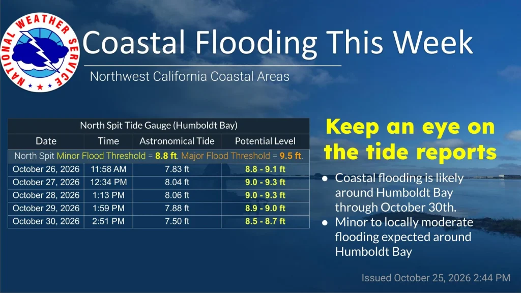
NWS Eureka has a separate Coastal Flood Advisory for Northern Coastal Humboldt County from 10:00 to 14:00 PDT (17:00–21:00 UTC) on October 26. Up to 0.15 m (0.5 feet) of saltwater inundation is possible near vulnerable shorelines and tidal waterways around Humboldt Bay.
The North Spit gauge is forecast to reach 2.71–2.8 m (8.9–9.2 feet MLLW), with high tide at 11:58 PDT (18:58 UTC). Flooding could affect Jackson Ranch Road in the Arcata Bottoms and roads in King Salmon.
References:
1 Coastal Hazard Message – NWS San Diego – October 25, 2026
2 Coastal Hazard Message – NWS Los Angeles/Oxnard – October 26, 2026
3 Coastal Hazard Message – NWS San Francisco – October 26, 2026

Rishav Kothari is Editor-in-Chief of The Watchers, where he runs the newsroom and covers earthquakes, volcanoes, severe weather and space weather.
Published in the last 24 hours
- 10 named storms, one hurricane for the first time since 1925: Why has the Atlantic been so quiet in 2026 Epicenter
- Amazon fire hotspots rise 82.6% in October 2026 as El Niño intensifies Epicenter
- In 2005, a driver near Russia's Chulyshman River picked up a stone to wedge under his car wheel and kept it for 20 years; the Meteoritical Bulletin has now approved it as the Altai Republic's first meteorite. Epicenter
- The Leonid meteor shower peaks on the night of November 17, exactly 60 years after the 1966 storm, when some observers reported meteors falling at up to 40 a second, though this year’s show should be closer to 15 an hour
