
Flash-flood risk rises in Southern California, severe storms threaten Arizona
Heavy rain and severe thunderstorms are forecast across the U.S. Southwest from October 21 into October 23, 2026, as a deep Pacific low draws tropical moisture inland. The Weather Prediction Center (WPC) placed parts of Southern California and the Southwest under a Slight Risk of excessive rainfall for October 21, while the Storm Prediction Center (SPC) placed parts of central and eastern Arizona under a separate Slight Risk of severe thunderstorms.
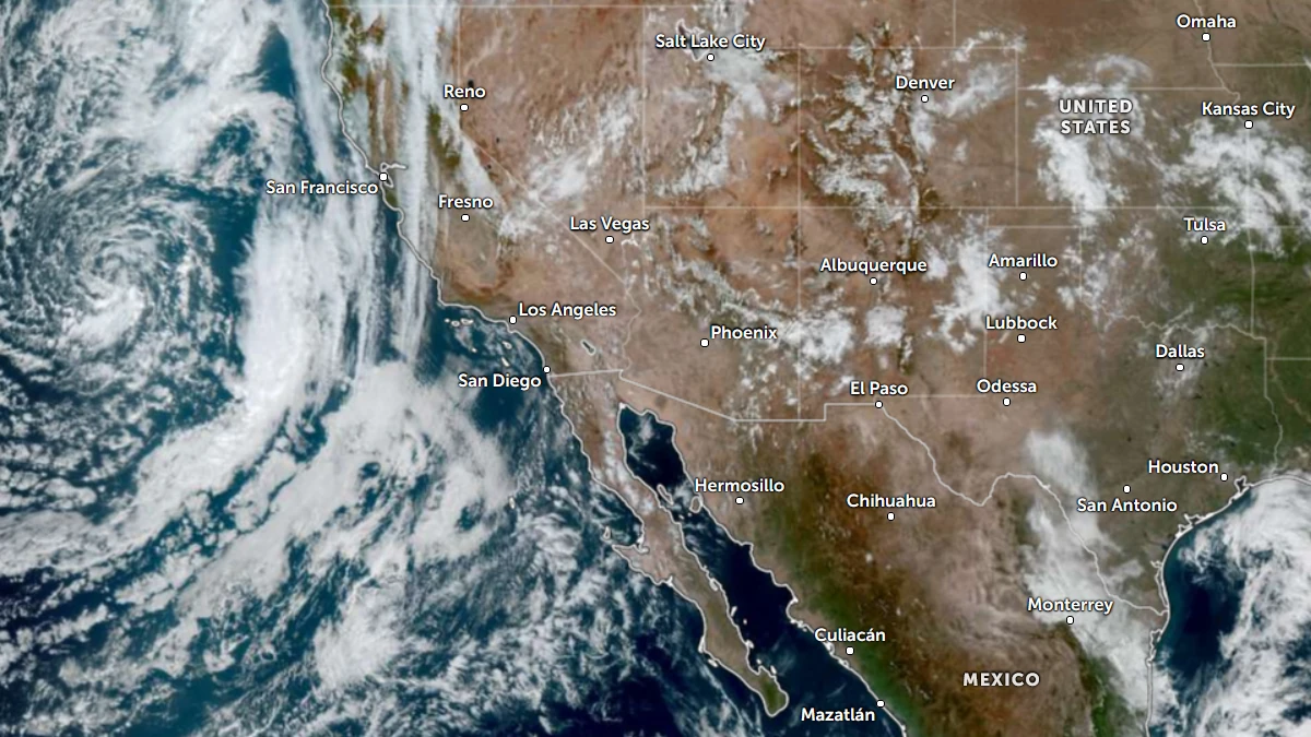
Satellite image of southwest U.S. at 17:20 UTC on October 20, 2026. Credit: NOAA/GOES-19, Zoom Earth, The Watchers
The WPC Excessive Rainfall Discussion issued at 15:33 UTC on October 20 places portions of Southern California, the Southwest and Four Corners under a Slight Risk from 12:00 UTC on October 21 to 12:00 UTC on October 22.
The update raised the coastal ranges north of Point Conception, the western Transverse Ranges and the Los Angeles metropolitan area to a Slight Risk. WPC also maintained a Marginal Risk in and near parts of Arizona through 12:00 UTC on October 21.
A broad area of integrated vapor transport reaching 300–600 kg m⁻¹ s⁻¹ is forecast to develop as the low approaches Southern California. Precipitable water near the circulation is expected to reach approximately 25–33 mm (1–1.3 inches).
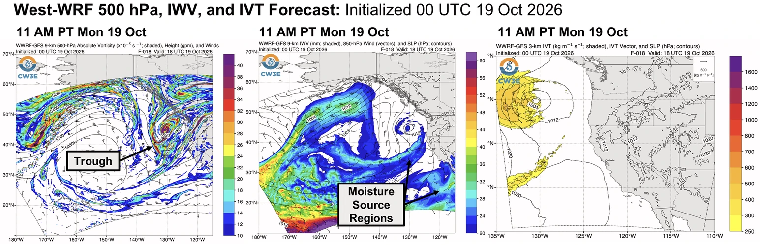
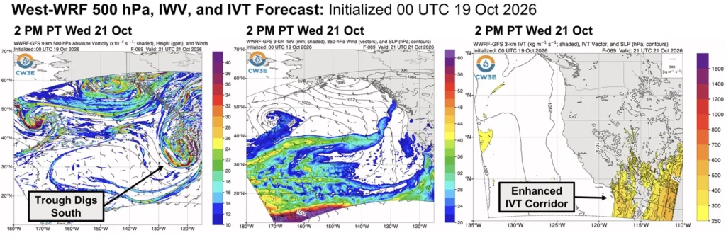
WPC said localized rainfall rates could reach 51 mm/h (2 inches/h) where thunderstorms train or repeatedly develop over terrain. These rates represent conditional local maxima rather than expected rainfall across the entire risk area.
A broad area of integrated vapor transport reaching 300–600 kg m⁻¹ s⁻¹ is forecast to develop as the low approaches Southern California. Precipitable water near the circulation is expected to reach approximately 25–33 mm (1–1.3 inches).
WPC said localized rainfall rates could reach 51 mm/h (2 inches/h) where thunderstorms train or repeatedly develop over terrain. These rates represent conditional local maxima rather than expected rainfall across the entire risk area.
NWS Los Angeles/Oxnard expects widespread rain to develop Wednesday and continue into Thursday. Its early-morning forecast called for totals near 25 mm (1 inch) across most coastal and valley areas and about 51 mm (2 inches) on favored south-facing slopes, with maximum rates near 19 mm/h (0.75 inches/h). Locally higher amounts remain possible beneath thunderstorms or training cells.
Across Arizona, New Mexico and the Four Corners, WPC forecasts precipitable water of approximately 19–38 mm (0.75–1.5 inches) and sufficient instability for organized thunderstorms. Localized rainfall rates could reach 64 mm/h (2.5 inches/h) where storms train, merge or repeatedly develop.
Urban areas, burn scars, slot and box canyons, dry washes and arroyos are particularly vulnerable to rapid runoff.
Forecast totals reach approximately 38–64 mm (1.5–2.5 inches) across foothills and higher terrain north and east of Phoenix. Average totals across the lower deserts are expected to remain below 25 mm (1 inch), although training thunderstorms could produce locally higher amounts.
SPC’s Day 2 Convective Outlook places parts of central and eastern Arizona under a Slight Risk of severe thunderstorms for October 21. A broader severe-weather area extends into southern Utah and western New Mexico.
SPC forecasts mixed-layer convective available potential energy exceeding 1 500 J/kg in parts of central Arizona as a southwesterly mid-level jet of 93–130 km/h (58–81 mph) crosses the region. Supercells may develop by late afternoon, producing damaging winds and severe hail, while one or two tornadoes are also possible.
WPC described portions of southeastern Arizona and southwestern Colorado as a higher-end Slight Risk area. Localized rates near 64 mm/h (2.5 inches/h) are possible, and embedded Moderate Risk areas may become necessary as forecast confidence increases.
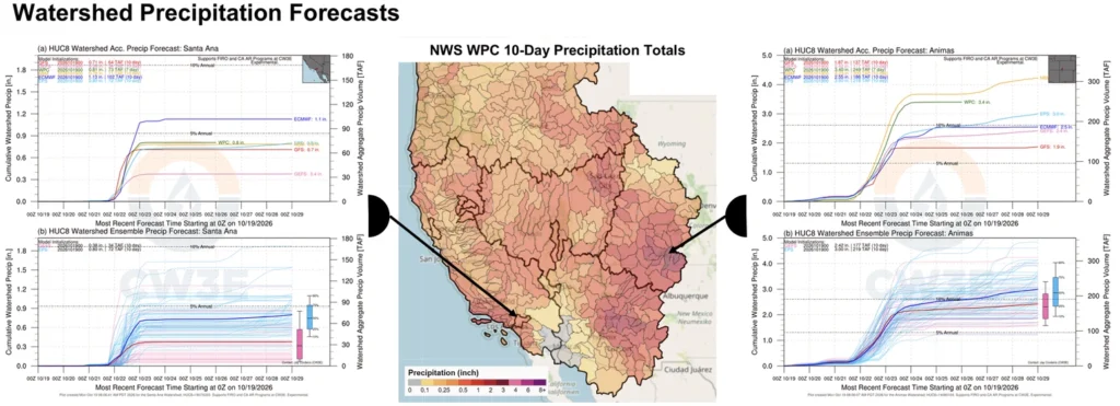
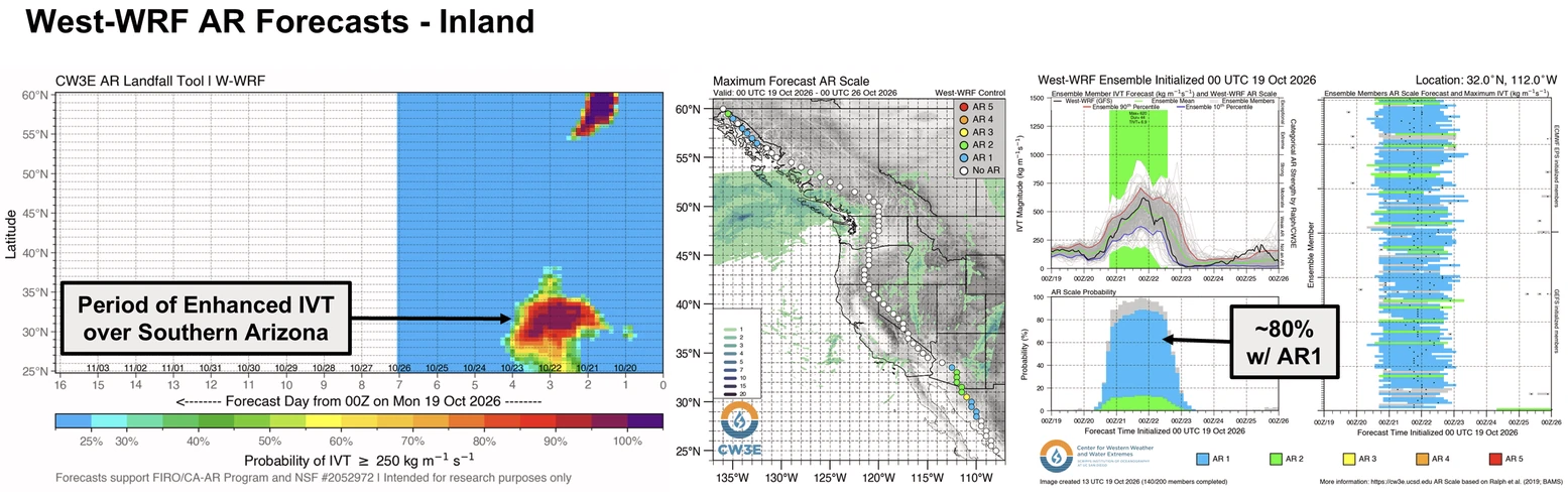
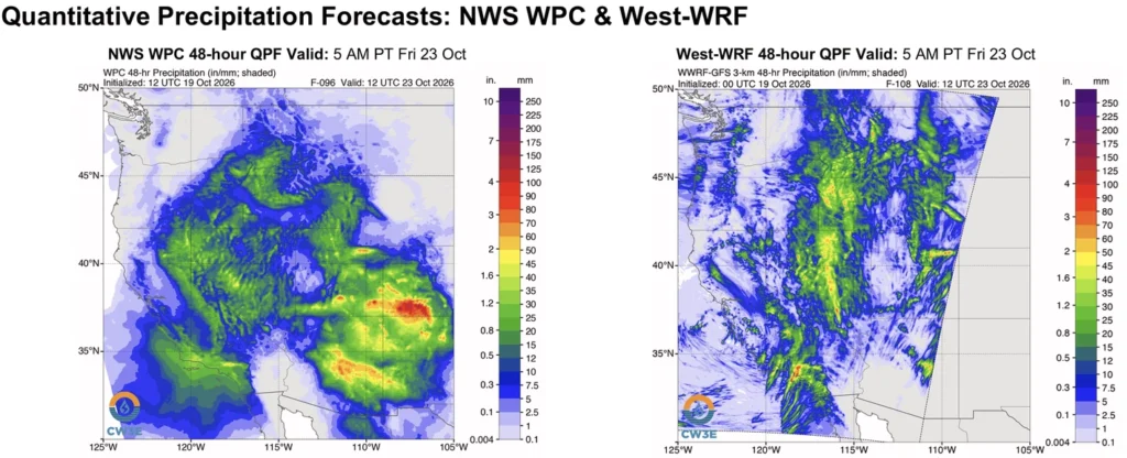
The Center for Western Weather and Water Extremes (CW3E) identified the developing pattern in its October 19 outlook. CW3E forecast the trough to interact with an eastern Pacific moisture plume and moisture associated with then-weakening Tropical Storm Trudy, producing moisture transport exceeding 500 kg m⁻¹ s⁻¹ over parts of the Southwest.
That outlook reproduced WPC 48-hour forecasts of 25–51 mm (1–2 inches) across Southern California and parts of Nevada, Utah, Arizona, Colorado and New Mexico. Totals of 51–127 mm (2–5 inches) were forecast in parts of central Arizona and southwestern Colorado. Those amounts came from the October 19 forecast cycle and preceded the subsequent Southern California risk upgrade.
References:
1 Precipitation Outlook: 19 October 2026 – CW3E – October 19, 2026
2 Excessive Rainfall Discussion – NWS/WPC – October 20, 2026
3 Day 2 Convective Outlook – NWS SPC – October 20, 2026

Rishav Kothari is Editor-in-Chief of The Watchers, where he runs the newsroom and covers earthquakes, volcanoes, severe weather and space weather.
Published in the last 24 hours
- How did one flash of lightning, lasting about seven seconds, stretch 829 km across five US states, beat the previous record by 61 km, and only be recognized as the longest ever measured nearly eight years later?
- A meteorite blew a crater beside a village near Lake Titicaca in 2007, and dozens of villagers who went to see it got headaches and nausea, though tests found nothing the rock had added to the water Epicenter
- The people who pay closest attention to the weather are the ones storms have already cost the most, a study of 946 students found, with one damaging storm making little difference to how much attention a student paid, but two or more making a clear one Epicenter
- The sea is falling in Juneau, Alaska, because land freed from melted glaciers is rising about 0.6 inches a year Epicenter
