
Typhoon and Flood watches cover Mariana Islands as Tropical Storm Champi approaches
Typhoon and Flood watches were in effect for Guam, Rota, Tinian and Saipan early October 16 as Tropical Storm Champi moved west toward the Mariana Islands. NWS Guam said damaging winds were likely late October 17 and on October 18, while storm-total rainfall of 152–305 mm (6–12 inches) could cause flooding in urban, low-lying and poorly drained areas.

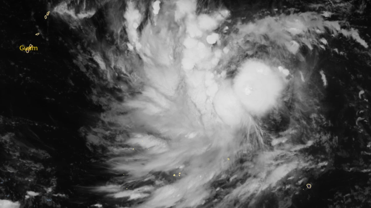
Satellite image of Typhoon Champi at 18:30 UTC on October 15, 2026. Credit: JMA/Himawari-9, RAMMB/CIRA, The Watchers
Tropical Storm Champi was moving west toward the Mariana Islands at 01:00 ChST on October 16 (15:00 UTC on October 15), with sustained winds of 65 km/h (40 mph) and its center about 1 330 km (825 miles) east of Guam.
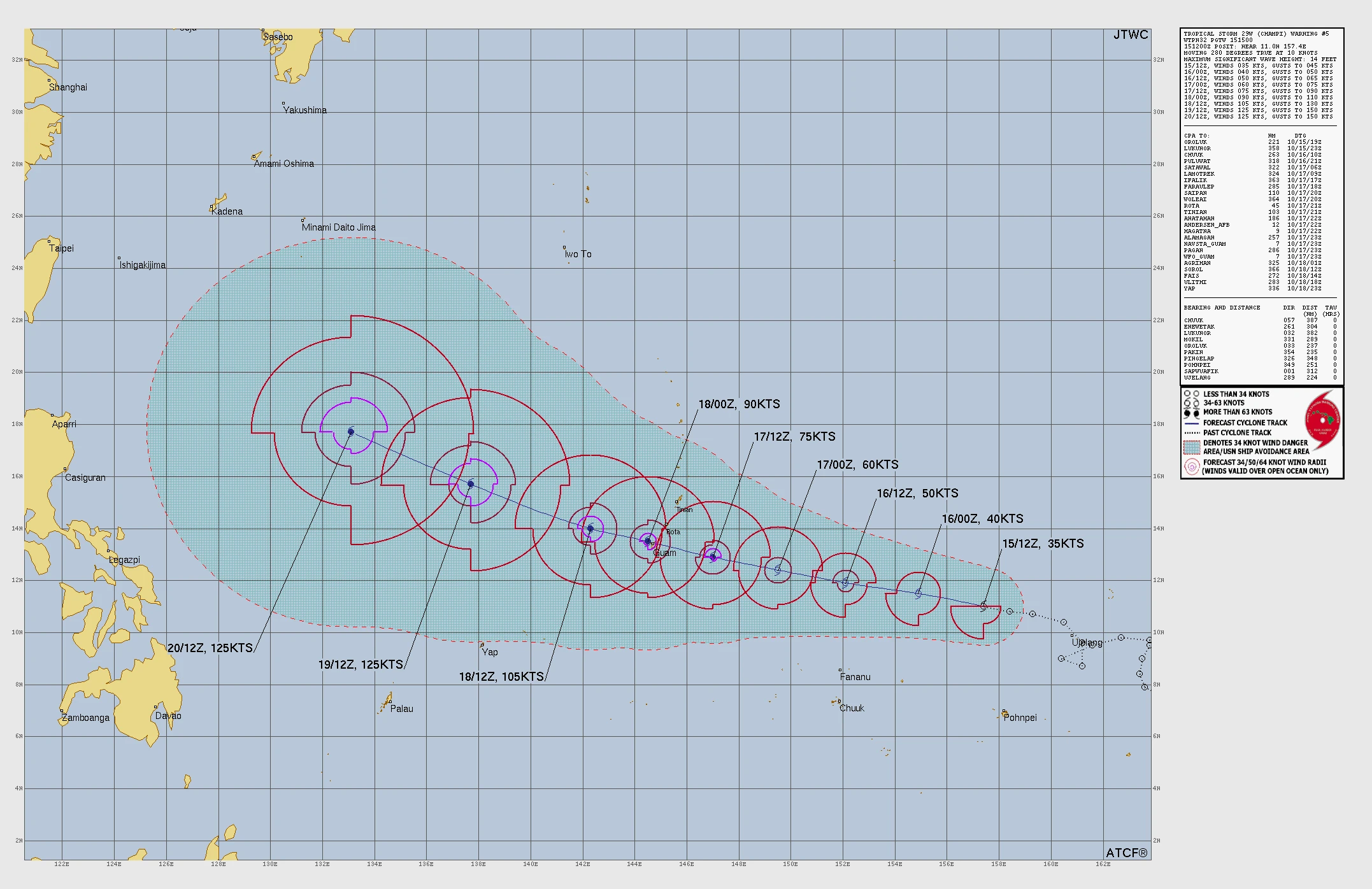
Typhoon and Flood watches were in effect for Guam, Rota, Tinian and Saipan as forecasters said Champi could become a typhoon on October 17 and pass close to Guam the following morning.
The storm was moving west at 19 km/h (12 mph), with tropical-storm-force winds extending up to 137 km (85 miles) southwest of the center and 72 km (45 miles) elsewhere.
Maximum sustained winds had increased to 65 km/h (40 mph), prompting the upgrade from tropical depression to Tropical Storm Champi. NWS forecast continued intensification through October 18, with the cyclone possibly reaching typhoon strength on October 17.
A Typhoon Watch remained in effect for Guam, Rota, Tinian, Saipan and their adjacent coastal waters. The watch means typhoon conditions, including sustained winds of at least 119 km/h (74 mph), are possible somewhere in the watch area within 48 hours.
Governor Lou Leon Guerrero placed Guam under Condition of Readiness 3 at 17:00 ChST (07:00 UTC) on October 15. Guam Homeland Security and the Office of Civil Defense said damaging winds were possible within 48 hours and urged residents to begin preparations.
In its 03:01 ChST update on October 16, NWS said damaging winds were likely across Guam and the Northern Mariana Islands late Saturday night and Sunday. Strong tropical-storm-force winds were forecast from early Sunday morning into Sunday afternoon, with typhoon-force winds possible near Champi’s center during mid- to late Sunday morning.
NWS cautioned residents against focusing on the exact forecast track. Its latest statement said the strongest winds were expected over the southernmost islands, while locations near the center should prepare for typhoon-force winds.
A Flood Watch is in effect for Guam, Rota, Tinian and Saipan through the afternoon of October 18. NWS forecast storm-total rainfall of 152–305 mm (6–12 inches), with flooding possible in urban, low-lying and poorly drained areas.
Surf is forecast to increase from 1–1.5 m (3–5 feet) on October 17 to 2–3 m (7–9 feet) that evening, before reaching 4.6–6 m (15–20 feet) on the morning of October 18.
Depending on Champi’s track, coastal inundation of 0.6–0.9 m (2–3 feet) is possible, with wave runup reaching 3.7 m (12 feet). NWS said all reefs could be exposed to dangerous conditions, although it remained too early to determine which coastlines would experience the greatest effects.
Marine conditions are forecast to deteriorate rapidly over the weekend. Seas could rise above 6.1 m (20 feet) during Champi’s closest passage, with dangerous conditions potentially continuing into October 19.
The Joint Typhoon Warning Center (JTWC) assessed Champi at 65 km/h (35 kt) at 15:00 UTC on October 15. It described conditions as favorable for strengthening, with sea-surface temperatures of 29–30°C (84–86°F), abundant atmospheric moisture, and vertical wind shear of 28–37 km/h (17-23 mph).
JTWC forecast rapid intensification beginning in about 36 hours, with Champi reaching typhoon strength shortly afterward. Model tracks ranged from south of Guam to northern Guam and the channel between Guam and Rota, leaving uncertainty over which islands could experience the cyclone’s core.
Champi developed from Invest 96W, became Tropical Depression 29W early October 15, and strengthened into a tropical storm early October 16 while moving toward the Mariana Islands.
References:
1 Tropical Storm Champi Advisory Number 5 – NWS Guam – October 16, 2026
2 Tropical Storm Champi Local Statement – NWS Guam – October 16, 2026
3 Prognostic Reasoning for Tropical Storm 29W, Warning Number 5 – JTWC – October 15, 2026

Rishav Kothari is Editor-in-Chief of The Watchers, where he runs the newsroom and covers earthquakes, volcanoes, severe weather and space weather.
