
Moderate Risk of excessive rainfall issued for parts of West Texas as flooding continues, U.S.
Heavy rainfall caused flash flooding across parts of West Texas on October 15, 2026, after totals exceeded 127 mm (5 inches) in some areas. The NOAA Weather Prediction Center (WPC) maintained a Moderate Risk of excessive rainfall over portions of West Texas through 12:00 UTC on October 16 as additional thunderstorms and flooding remained possible.
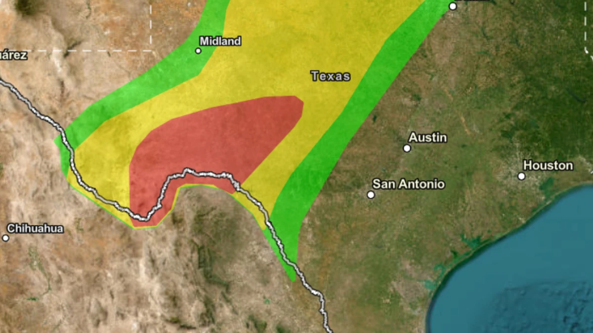
Map of area covered by WPC Moderate Risk ERO on October 15, 2026. Credit: NWS/WPC
The WPC said a southward-moving cold front would interact with deep moisture over the Southern Plains, concentrating heavy rainfall across West Texas into early October 16.
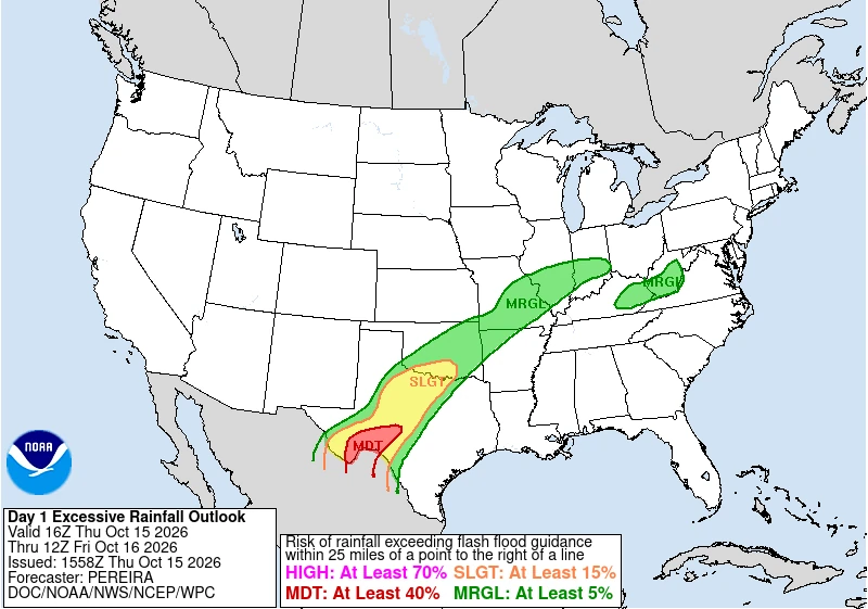
Its Day 1 Excessive Rainfall Outlook, issued at 06:44 UTC on October 15, placed portions of West Texas under a Moderate Risk, the second-highest of WPC’s four excessive-rainfall categories.
Farther north, rainfall had already produced flooding before the main West Texas risk period began. NWS Lubbock reported that totals over the preceding 24 hours had exceeded 127 mm (5 inches) in spots across portions of the Rolling Plains and southern Texas Panhandle, with another round of heavy showers and thunderstorms expected through Thursday morning. The agency said additional flooding or continuation of flooding already underway was possible.
Flash flooding was directly observed in the Lubbock area early October 15. At 06:07 CDT (11:07 UTC), NWS Lubbock issued a Flash Flood Warning for central Lubbock County and northwestern Crosby County after members of the public reported flooding.
Between 25–51 mm (1–2 inches) had fallen, with another 13–25 mm (0.5–1 inch) possible. The warning covered Lubbock, Wolfforth, Idalou, downtown Lubbock, Texas Tech University and Lubbock International Airport.
That warning expired at 08:00 CDT (13:00 UTC) after the heavy rain ended, but NWS continued to advise motorists to observe remaining road closures.
A Flood Watch remained in effect for portions of the Rolling Plains and southern Texas Panhandle through noon, while the office’s 05:38 CDT outlook called for scattered to numerous showers and thunderstorms to continue over the Rolling Plains through the first half of the day.
Flash-flood problems were not confined to the Lubbock area. NWS Midland/Odessa issued Flash Flood Warnings during the early morning for parts of Brewster and Terrell counties in southwest Texas, where radar indicated thunderstorms producing heavy rain.
In Terrell County, 13–25 mm (0.5–1 inch) had fallen by 05:07 CDT, with up to another 25 mm (1 inch) possible and flash flooding ongoing or expected to begin shortly.
Across northern Texas, NWS Norman extended a Flood Watch through 19:00 CDT on October 15 for counties including Hardeman, Foard, Wilbarger, Wichita, Knox, Baylor, Archer and Clay. By 08:42 CDT, the office had also issued a river Flood Warning for Beaver Creek near Electra in Wilbarger and Wichita counties, where minor flooding was forecast from Thursday evening into October 19.

The developing flood threat prompted a state-level response before the heaviest West Texas rainfall. On October 13, Governor Greg Abbott directed the Texas Division of Emergency Management to activate state emergency resources for severe weather, heavy rainfall, and potential flash flooding.
Resources made available included swift-water rescue teams, high-profile vehicles, rescue boats, helicopters with hoist capability, emergency medical teams, and state personnel monitoring roads, utilities, and other infrastructure.
WPC Mesoscale Precipitation Discussion, issued at 09:20 UTC on October 15, described thunderstorms training along a nearly stationary outflow boundary and an approaching cold front over the Southern Plains.
Radar estimates showed swaths of 25–76 mm (1–3 inches) during the preceding six hours, while short-term guidance supported maximum rainfall rates near 51 mm/h (2 inches/h) and additional localized totals of 25–76 mm (1–3 inches). WPC said scattered flash flooding could persist into the morning.
The primary West Texas threat remained additional excessive rainfall through early October 16. WPC’s latest Day 1 discussion retained the Moderate Risk over portions of the region, while local NWS offices continued to maintain flood watches across parts of West, Southwest, and West-Central Texas.
References:
1 Day 1 Excessive Rainfall Outlook – WPC – October 15, 2026
2 Governor Abbott Activates State Emergency Response Resources Ahead of Flood Threat – Office of the Texas Governor – October 13, 2026

I’m a science journalist and researcher at The Watchers, contributing to the Epicenter edition, where I cover peer-reviewed scientific research and emerging discoveries across Earth and space sciences. With a background in astronomy and a passion for environmental science, I’ve worked in shark and coral conservation in Fiji, conducting reef and shark-behavior research, contributing to mangrove restoration, and earning PADI Open Water and Coral Reef Certifications. I bring a blend of scientific rigor and storytelling to illuminate the discoveries shaping our planet and beyond.
Published in the last 24 hours
- El Niño reaches 2.0°C on NOAA’s index, a tenth of a degree behind 1997–98 at the same point, as forecasters expect it to challenge the all-time record this winter
- The fastest wind gust ever measured on Earth, 253 mph, hit an oil island off Australia during Cyclone Olivia in 1996, and nobody noticed for more than a decade, until experts reading old data quietly took the record from New Hampshire's Mount Washington Epicenter
- In 1954, a grapefruit-sized meteorite crashed through a roof in Sylacauga, Alabama, and struck Ann Hodges as she napped on her couch Epicenter
- A meteorite blew a crater beside a village near Lake Titicaca in 2007, and dozens of villagers who went to see it got headaches and nausea, though tests found nothing the rock had added to the water Epicenter
