
Major M7.7 earthquake hits Flores region, Indonesia, leaving 105 dead
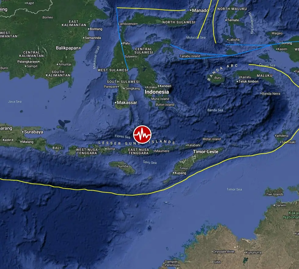
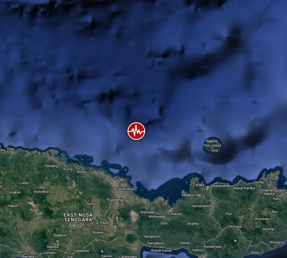
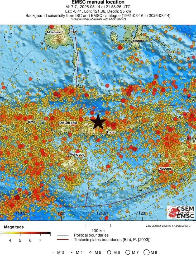
A major earthquake registered by the USGS as M7.7 hit 68 km (42 miles) NNW of Ende, Indonesia at 21:58 UTC on August 14, 2026. The agency is reporting a depth of 10 km (6.2 miles). EMSC is reporting M7.7 at a depth of 35 km (21.7 miles). BMKG reported M7.7 and a tsunami potential following the earthquake.

Epicenter of M7.7 earthquake in Flores Region, Indonesia on August 14, 2026. Credit: TW/SAM, Google
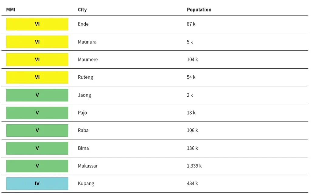
The epicenter was located 70 km (45 miles) NNW of Ende (population 87 269), 100 km (60 miles) WNW of Maumere (population 87 720), 105 km (65 miles) ENE of Ruteng (population 41 533), 165 km (100 miles) E of Labuan Bajo (population 188 724), and 325 km (200 miles) NW of Kupang (population 442 758), East Nusa Tenggara, Indonesia.
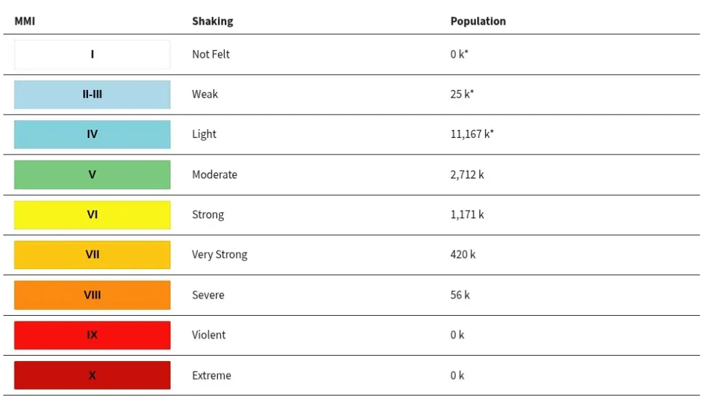
56 000 people are estimated to have felt severe shaking, 420 000 very strong, 1 171 000 strong, 2 712 000 moderate, 11 167 000 light and 25 000 weak.
BMKG said tsunami waves were possible based on modeling and placed 22 areas under Alert status across East Nusa Tenggara, West Nusa Tenggara, South Sulawesi and Southeast Sulawesi. Estimated tsunami arrival times ranged from 22:02 to 23:41 UTC (05:02 to 06:41 WIB on August 15).
Alert areas included North Manggarai, Northern Ngada, the northern part of West Manggarai, North Ende, Ende Island, North Sikka, Sikka Island and northeastern Flores in East Nusa Tenggara; Sangiang Island, Gili Island, North Bima City and North Dompu in West Nusa Tenggara; Selayar, Jeneponto, Bantaeng, Takalar, Bone, Wajo, East Luwu, North Luwu and Palopo City in South Sulawesi; and Bau-Bau City in Southeast Sulawesi.
BMKG advised local governments in areas under Alert status to immediately direct residents to evacuate and to stay away from beaches and riverbanks.
The USGS issued a Yellow alert for shaking-related fatalities and economic losses. Some casualties and damage are possible and the impact should be relatively localized. Past yellow alerts have required a local or regional level response. Estimated economic losses are less than 1% of GDP of Indonesia.
Overall, the population in this region resides in structures that are vulnerable to earthquake shaking, though resistant structures exist. The predominant vulnerable building types are unreinforced brick with concrete floor and precast concrete frame with wall construction. Recent earthquakes in this area have caused secondary hazards such as tsunamis and landslides that might have contributed to losses.
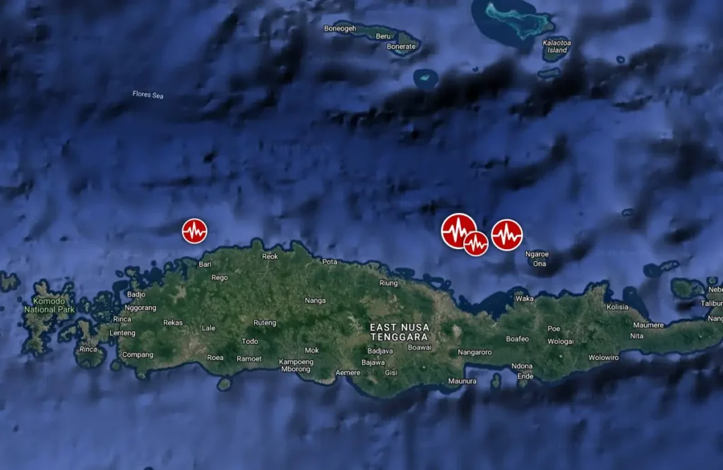
According to USGS data, the quake was followed three aftershocks by 22:28 UTC – M5.9 at 22:13 UTC, M5.6 at 22:18 UTC, and M6.1 at 22:28 UTC.
Estimated population exposure to earthquake shaking
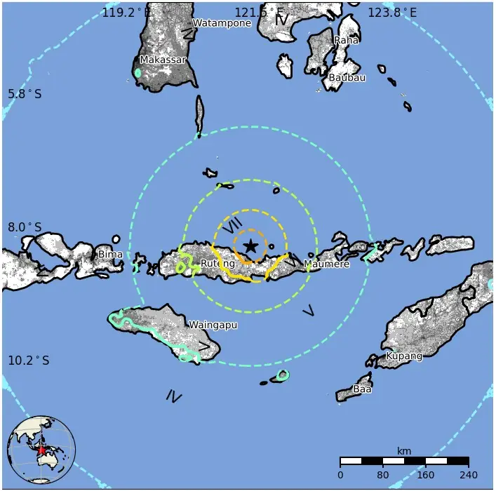
Selected cities exposed
Regional seismicity
Updates
07:34 UTC, August 15
BMKG monitoring stations recorded tsunami waves at 10 coastal sites. The highest observation was 0.94 m (3.1 feet) at Maurole-Ende, followed by 0.54 m (1.8 feet) at Bulukumba, 0.38 m (1.2 feet) at Kewapante-Sikka and 0.36 m (1.2 feet) at Labuan Bajo. Smaller waves were recorded at Sikka, Flores Timur, Dompu, Bakalang-Alor, Baubau and Kolaka.
The tsunami warning was terminated at 07:30 WIB (00:30 UTC), after the monitoring network no longer recorded sea-level increases considered dangerous along the affected coasts.
BMKG’s impact update at 12:30 WIB (05:30 UTC) included 14 deaths: three in Sikka Regency, six in Manggarai Regency and five in East Manggarai Regency. Two people were seriously injured and 11 sustained minor injuries, with injuries reported in Sikka, Nagekeo, Manggarai and East Manggarai. BNPB said the figures remained under field collection, verification and validation.
About 2 000 residents evacuated or moved to safer locations after the strong shaking and tsunami warning, according to BNPB. The agency’s preliminary damage inventory said 54 homes were heavily damaged, nine moderately and 11 lightly, along with five health facilities, one educational facility, one Bulog warehouse, three places of worship and six government offices.
Heavy residential damage included 29 homes in Manggarai, 23 in East Manggarai and two in Nagekeo. BNPB also reported traffic congestion and a continuing power outage in Nagekeo during the assessment period.
BMKG’s Kupang Geophysical Station counted 111 aftershocks by 10:00 WITA on August 15, with the most recent event at that reporting time measuring M3.8.
Authorities advised residents to remain alert for additional aftershocks and to avoid or inspect buildings showing cracks or structural damage before re-entering them.
BMKG identified the Flores Back-Arc Thrust as the source of the earthquake and cited the M7.5 Flores earthquake in 1992 as a previous major event in the same regional tectonic setting that also produced damaging effects and a tsunami.
13:30 UTC, August 15
BNPB raised the confirmed death toll to 47 based on provisional data compiled at 18:48 WIB (11:48 UTC). The agency reported 24 deaths in Manggarai Regency, 17 in East Manggarai, three in Sikka, and one each in West Manggarai, Ngada and Ende. BNPB said injured residents continued to be evacuated and treated, but did not provide a new consolidated injury total in its latest release.
Data collected by 17:00 WIB (10:00 UTC) showed 157 homes heavily damaged, 41 moderately damaged and 148 lightly damaged. BNPB also recorded damage to 87 educational facilities, 18 health facilities, five places of worship, six government offices and other public facilities.
A later BMKG assessment revised the highest observed tsunami measurement upward. Tide gauges recorded a peak wave of 1.61 m (5.3 feet) at Reo in Manggarai and Manggarai Timur, while Maurole-Ende recorded 0.94 m (3.1 feet). Bulukumba and Sape Bima recorded waves exceeding 0.5 m (1.6 feet). The tsunami warning remained terminated after BMKG determined sea levels had returned to safe conditions.
BMKG also reported that the aftershock sequence reached 235 events by 14:00 WIB (07:00 UTC), ranging from M2.5 to M6.2. The agency said the sequence had not yet shown significant decay and estimated, based on its assessment of previous damaging-earthquake sequences, that natural aftershock decay could take approximately two to three weeks.
Updated intensity mapping placed the strongest observed shaking at VII MMI in Aesesa, Riung, Kota Ambai and micro-observation areas around Manggarai and Ruteng. VI MMI shaking was recorded in Wolowae and Bajawa.
The central government expanded emergency operations as search, rescue and damage assessment continued. Basarnas deployed specialist SAR teams from Bali and West Nusa Tenggara to assist with people trapped under collapsed structures, while public-works teams were assigned to clear earthquake-triggered landslides affecting roads and waterways. BNPB asked affected local governments to establish emergency-response status and activate command posts to coordinate search and rescue, impact assessment and displaced residents.
BNPB said five of NTT’s 15 airports sustained earthquake damage, although their runways remained usable and damage was concentrated in terminal buildings. Two port facilities were heavily damaged, and two ferry facilities were also affected. Helicopters and aircraft were placed on standby under BNPB coordination, while military personnel, aircraft and vessels were mobilized to support the response.
The agency began moving food and non-food assistance from its Flores Timur logistics warehouse and from Jakarta. Its latest update said 50 000 aid packages weighing 275 tonnes were being prepared for delivery, with 10 500 packages already at the Halim Perdanakusuma air base. Rapid impact assessment and verification remained underway, meaning the casualty and damage totals were still provisional.
07:46 UTC, August 27
The death toll from the M7.7 earthquake that struck Flores, East Nusa Tenggara, on August 15 has risen to at least 105, according to the latest national-level update from Indonesia’s National Disaster Mitigation Agency (BNPB). The agency reported 1 678 people injured, while 179 037 people remained displaced as of August 26.
The provincial disaster agency, BPBD NTT, reported a higher toll of 111 deaths and 1 693 injuries as of 08:00 WITA on August 26.
BNPB Chief Suharyanto reported that 81 436 homes had been damaged across the affected region. BNPB has deployed rehabilitation and reconstruction teams to seven affected regencies and is conducting detailed assessments to classify homes as heavily, moderately or lightly damaged before reconstruction assistance is distributed.
BMKG recorded 7 787 aftershocks by 18:00 WITA on August 26, ranging from M1.0 to M6.2. Of these, 33 measured above M5 and 143 were reported felt. A further M4.6 earthquake struck 51 km (32 miles) northeast of Ruteng at 18:34 UTC on August 26, at a depth of 10 km (6.2 miles).
President Prabowo Subianto visited Nagekeo on August 26 and led a coordination meeting with BNPB, BMKG and other agencies. He instructed authorities to delay permanent housing construction and major repairs until BMKG determines that seismic conditions are sufficiently stable.
Indonesia’s Ministry of Public Works reported on August 27 that all national roads blocked by earthquake-triggered landslides had been reopened, restoring national-road connectivity across Flores and improving access for relief distribution and recovery operations.
References:
1 M7.7 earthquake 68 km NNW of Ende, Indonesia – USGS – August 14, 2026
2 M7.7 earthquake Flores Region, Indonesia – EMSC – August 14, 2026

Teo Blašković founded The Watchers in 2011 and edited it until 2026, covering seismic and volcanic activity, extreme weather, space weather and near-Earth objects. Articles on this page are his archive.
