
Tropical Depression Bising strengthens on its way toward Taiwan
Tropical Depression Bising continues to strengthen off the coast of northern Luzon after exiting the Philippines Area of Responsibility on July 4, 2025. The current forecast takes it west of Taiwan on July 6 and 7, and then into China on July 8.
Tropical Storm Five formed off the western coast of extreme northern Luzon on July 3, according to the advisory issued by the Indo-Pacific Tropical Cyclone Warning Center (IPTCWC) at 21:00 UTC.
While IPTCWC has classified it as a Tropical Storm, the Philippine Atmospheric, Geophysical and Astronomical Services Administration (PAGASA) maintained its designation as Tropical Depression Bising.
Bising exited the jurisdiction of PAGASA around 07:00 UTC on July 4, and continued strengthening. According to the Joint Typhoon Warning Center (JTWC), the system was located around 698 km (433 miles) south-southwest of Taipei, Taiwan as of 09:00 UTC on July 4.
The system is forecast to continue moving westward to west-northwestward, guided by a low-level steering ridge to its north, during the next 24 hours.
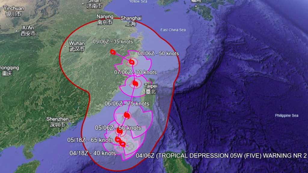
Biseng is forecast to rapidly intensify and turn north-northeastward on July 5, following a strengthening steering ridge to the east. It is expected to reach a peak intensity of 140 km/h (86 mph) within 48 hours due to favorable conditions, including strong outflow and warm sea surface temperatures.
While the earlier IPTCWC forecast stated that the system could become a typhoon as it approaches Taiwan, the JTWC forecast indicates otherwise. As the storm moves through the Taiwan Strait, it is forecast to weaken, according to JTWC. This weakening is attributed to warm, dry air flowing off the mountains of Taiwan and entering the storm’s core.
The forecast confidence is low due to uncertainty in the short-term and longer-term track near Taiwan. This track uncertainty also affects the intensity forecast, as the storm’s proximity to Taiwan may influence its strength.
Feature image credit: Himawari-9, RAMMB/CIRA, The Watchers. Acquired at 07:50 UTC on July 4, 2025.

Rishav Kothari is Editor-in-Chief of The Watchers, where he runs the newsroom and covers earthquakes, volcanoes, severe weather and space weather.
Published in the last 24 hours
- Second nationwide US flight halt since 9/11: how the November 13 FAA ground stop compares with September 2001 and January 2023 Epicenter
- FAA grounds all departing flights across the US after communications outage hits air traffic control centers nationwide
- In September 1859, a solar storm lit up the night sky so brightly that gold miners in the Rocky Mountains woke up after midnight and started cooking breakfast, convinced the aurora glowing over their camp was the sunrise Epicenter
- A patch of warm Pacific water that could become the strongest El Niño in more than 70 years sits thousands of miles from any American town, yet it is already the main reason NOAA expects a wetter winter across the South and a milder one across the North
