
Extremely dangerous winter weather setup across the southern Alpine flank
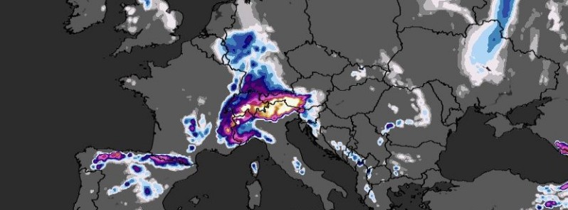
Image credit: WXCharts
An extreme, potentially catastrophic amount of rain and especially snow could develop across the southern Alpine flank over the coming weekend, leading to potentially catastrophic avalanches.
Potentially a very dynamic weather pattern change is shaping up for central Europe in the coming days, as a very deep trough will dominate the continent, Severe Weather Europe's Marko Korosec notes.
Weather models are hinting that 500 – 700 mm (20 – 27 inches) of accumulated precipitation will be possible across the northeast Italian and southern Austrian mountainous terrain, Korosec said, adding that more than 4 meters (13 feet) of fresh snow could accumulate until Monday, December 7.
"The real concern is the extreme amount of snow expected over the southern Alpine flank this weekend – up to 4 m (13 feet) of fresh snow could lead to catastrophic avalanches," Korosec warns.
These amounts of rain and snow hint at a HIGH RISK for flooding and especially an extremely dangerous avalanche risk for the region.
A full analysis of the event can be found here.
I'm a dedicated researcher, journalist, and editor at The Watchers. With over 20 years of experience in the media industry, I specialize in hard science news, focusing on extreme weather, seismic and volcanic activity, space weather, and astronomy, including near-Earth objects and planetary defense strategies. You can reach me at teo /at/ watchers.news.
Commenting rules and guidelines
We value the thoughts and opinions of our readers and welcome healthy discussions on our website. In order to maintain a respectful and positive community, we ask that all commenters follow these rules.