
Intense Arctic outbreak expected over much of Ontario, Canada and parts of eastern U.S. — record cold, rare May snow expected
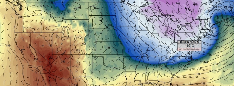
Image credit: pivotal weather
Intense Arctic air outbreak is expected over much of Ontario, Canada, and the eastern parts of the United States– possibly bringing record cold temperatures in some areas late this week into the next. The cold outbreak may also allow for some rare May snow in parts of the Northeast and frost as far south as the interior Carolinas. TWC meteorologist Michael Palmer said the incoming Arctic cold outbreak will be one of the 'coldest modified polar air masses on record so late in the season.'
The coldest air is set to swirl across Ontario, Canada, by Friday, May 8, 2020. According to Gerald Cheng, a warning preparedness meteorologist with Environment Canada, a polar vortex that has been sitting over the North Pole for much of winter is starting to break down, and a huge chunk will fall onto eastern Canada, before heading toward the U.S.'s eastern portion.
"Usually this cold wind remains in the pole, for us that’s the North Pole, but it is being pushed down right now into Ontario," he said. "When that northern air comes south, that’s when we feel that really cold weather."
Several areas of eastern and southern Ontario can expect to feel below freezing temperatures on Friday and Saturday, with colder temperatures lingering around until Sunday. Some areas may also experience snow flurries and squalls.
Cheng said citizens will feel the effects of the polar vortex throughout the next week.
Meanwhile, in the U.S., while temperatures in many areas east of the Rockies have already pummeled, a stronger cold front will send temperatures dropping even lower late week.
An intensified weather pattern more similar to winter than late spring will start to break down next week, particularly over the Great Lakes and the Northeast, the National Weather Service (NWS) stated.
"Deep troughing in the east will be responsible for widespread record and near-record lows this weekend with only a slow moderation early next week." NWS added, "Also over some areas this cold surge would lead to a late frost/freeze where the growing season has already started," pertaining to the Northeast and the interior Carolinas.
Colder temperatures will hit the Upper Midwest and the Great Lakes on Thursday into Friday, May 7 into 8, barreling across the East Coast. Cities such as Minneapolis, Chicago, and Detroit may feel the coldest day on Friday, while the core of the Arctic air mass settles over cities from Washington to Boston on Saturday, May 9.
Much of the Great Lakes may experience freezing cold Saturday morning, and much of the interior Northeast on Sunday morning– some of which may set records. Frost will also be likely as far south as the interior Mid-Atlantic and the western Carolinas on Sunday.
Michael Palmer, a meteorologist at the Weather Company, said the incoming Arctic cold outbreak will be one of the "coldest modified polar air masses on record so late in the season." Models forecast that the intensity of the cold air mass over Pittsburgh on Saturday will be the most extreme recorded in May.
The system is forecast to exit the Northeast on Sunday into Monday, May 10 into 11. However, colder than usual temperatures are likely to remain through mid-May.
What's causing this period of record chill across Great Lakes & Northeast? Piece of polar vortex has descended southward from its anchor point on Hudson Bay into NE Lower 48.
This is highly unusual for mid-May & likely a manifestation of "jet weirding" due to climate change. pic.twitter.com/RNI2Qb4J6v
— Ryan Maue (@RyanMaue) May 6, 2020
The upcoming shot of May chill later this week means business. The Euro predicts temps around -10ºC at ~5,000 ft over Pittsburgh on Saturday morning. Even the "warmer" ensemble members are around -7ºC
The lowest May temp on record at that level is -9.3ºC (data since 1952). #pawx pic.twitter.com/wUdQo76cNv
— Weather World (@WeatherWorldPSU) May 4, 2020
It's May, so here's a GFS forecast showing the potential for snow squalls on Saturday morning.
Enjoy your week! #pawx pic.twitter.com/tzhBWTqMMZ
— Steve Seman (@SteveSeman) May 4, 2020
No snows in Michigan. Just a killing freeze that will destroy any orchard fruits and the crops in the ground. Some forecasts put the freeze at 23 degrees, any planted crops will be dead if they germinated.
Grand solar minimum goes on
Between the GSM, increased volcanic activity, and loss of local heating from human activity you know that we’re facing a mini-ice age.
But that goes against the global warming industry.