
Series of strong storms to dump heavy rain and snow on Pacific Northwest, U.S.
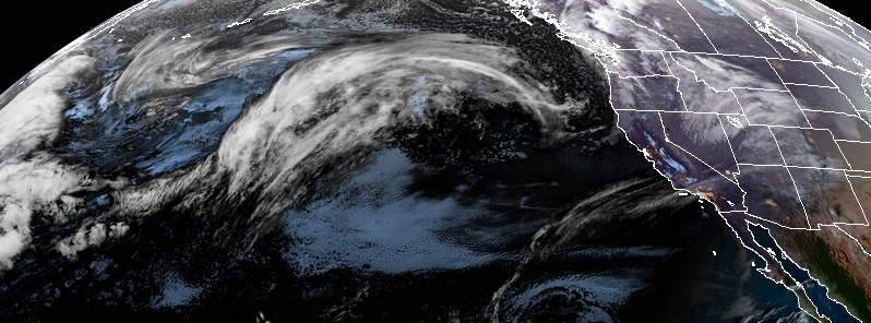
Image credit: NOAA/GOES-West. Acquired: 15:30 UTC on January 5, 2020
Several strong storms are expected to bring heavy rain and snow to parts of the Northwest in the week ahead. As the active weather pattern continues through the coming week, storms will line up to track across the region, with a cold front moving through Sunday, and a warm front approaching on Monday, January 6, National Weather Service (NWS) reported.
A storm through the Pacific Northwest brought periods of rain and mountain snow to the area late Friday into Saturday, January 4 to 5, 2020, with widespread wind gusts of 65 to 80 km/h (40 to 50 mph), AccuWeather said.
The winds knocked down trees and caused power outages on Friday night.
Update: Crew estimates 10:00 p.m. or later for restoration. pic.twitter.com/0YRqsNfk9D
— Mason County PUD #1 (@MasonCountyPUD1) January 4, 2020
The storm system is set to spread rain, snow and gusty winds into the interior Northwest, northern Plains, and the central Rocky Mountains through the weekend. Meanwhile, another storm will continue heading for the Northwest on Sunday.
This second storm will dump another round of rain to the coast and snow to the Cascades. However, forecasts said it will not be as powerful as the earlier storm.
"This quick-moving system will also bring some showers west of the Cascades late in the day on Sunday," said AccuWeather Senior Meteorologist Dave Houk.
On January 6, another storm is expected to head for the Gulf of Alaska as the first half of the storm reaches the Pacific Northwest. Massive amounts of moisture will bring a round of heavy, coastal rain and heavy snow to the western slopes of the Cascades on the same day. Warmer air is also forecast to move into the region, limiting snow to elevations above 1 829 m (6 000 feet).
The heaviest precipitation will be drawn north into the Olympic Peninsula and southern Canada as the second half of the storm reaches the coast on Monday night.
The pattern across the Northwest will remain active through the coming week as storms line up to track across the region: https://t.co/UqEjmwV1jB pic.twitter.com/TdWLWzRCfn
— AccuWeather (@breakingweather) January 4, 2020
On Tuesday, January 7, the storm is expected to move into southern British Columbia, which will bring a cold front to the Pacific Northwest. As rain and high-elevation snow remain in northwestern Washington, a new round of rain will arrive for Oregon and far Northern California.
"This persistent pattern of rain should help to alleviate, at least to some degree, the moderate drought conditions currently plaguing the area," said AccuWeather Meteorologist Max Gawryla.
A fresh round of cold air will follow behind the storm, and by Tuesday night, snow levels will pummel to around 915 to 1 200 m (3 000 to 4 000 feet), posing risks to travel in some mountain passes.
Several rounds of subtropical moisture are expected to bring heavy rain and mountain snow to the Northwest into the middle of this week. Travel could be difficult at times, especially through the mountain passes.https://t.co/I05i0rpabW pic.twitter.com/3mnbZSSg1L
— WeatherNation (@WeatherNation) January 4, 2020
Snow is expected across Idaho and Montana into Wednesday, January 8, as the storm moves inland, spreading snow across the interior mountains.
A couple of rain and snow shower may occur in the valleys, but mainly dry conditions can be expected. In higher elevations, snow showers may remain through Thursday, January 9, as the storm system slowly exits the region.
"This quick break in the onslaught of storms will come to a close by the end of the week," AccuWeather noted.
Here is the latest precipitation forecast for the next 7 days. Wet weather is forecast to continue across the Pacific Northwest. Further east, widespread heavy rain is increasingly likely from the Lower Mississippi Valley to the Ohio Valley beginning on Thursday. pic.twitter.com/wM6CJ3sFrI
— NWS WPC (@NWSWPC) January 5, 2020
However, Houk added, "After some showery spells on Wednesday and Thursday, a bigger storm looks to come in again late in the week."
The powerful storm is forecast to move along the Canadian coast and slide into the Pacific Northwest on Friday and into Saturday, January 10 to 11. According to forecasters, the storm will again bring another round of coastal rain and heavy snow to the western-facing slopes of the mountains.
I hope we realize some benefitsz from this