
Flash floods batter Devon and Cornwall, southwest England
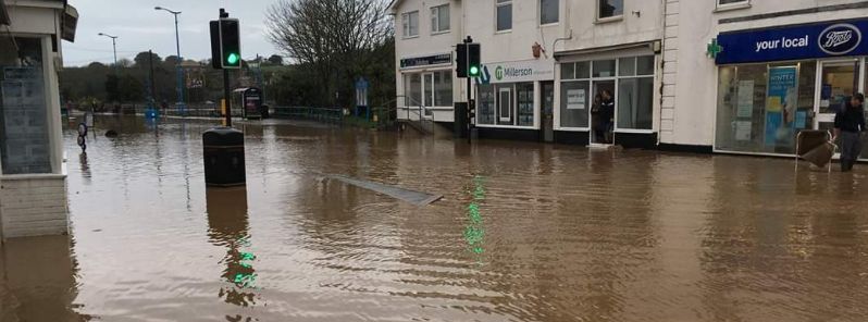
Image credit: @Official_WXUK/Twitter
Heavy rain and gale-force winds battered the Devon and Cornwall counties in southwestern England on December 18, 2019, knocking down trees and sparking floods that led to road closures.
Several vehicles have become stranded on the A303 in Newcott, Devon. The eastbound carriageway was completely closed as a result.
The A3083 in Cury Cross Lanes, Cornwall was also closed in both directions due to a fallen tree. Heavy traffic was reported on the A30 due to surface water near the Jamaica Inn.
In a similar manner, the A381 was blocked in both directions after another tree fell across the road.
In Plymouth, surface water on the A38 at The Parkway caused problems for drivers. The traffic eventually improved and earlier tailbacks were dispersed.
Adding to the list of closed roads was he B3344 Le Molay-Littry Way in Chudleigh Knighton. Reports said there was a collision, from Red House Close to Bradley Road.
Elsewhere in Devon, the A386 at Landcross was said to be passable but debris on the road and flooding made travel difficult. There was also flooding on the B3215 North Tawton, so authorities warned motorists to approach with care.
On December 19, Devon and Cornwall Police have declared a major incident as flash flooding left Hayle submerged.
The A30 Hayle bypass was left closed due to the volume of water, while a part of the town center was blocked too. Although the road has reopened eventually, slow traffic was reported in the area.
HAYLE FLOODING UPDATE:
Water has now completely receded from Fore Street, Hayle.There is more rain forecast for later and tomorrow, but not as severe. Please continue to take care on the roads.
Please find flood advice here: https://t.co/TRstC5CrGI
— Cornwall Council (@CornwallCouncil) December 19, 2019
More pictures of the flooding in #Hayle Town Centre where a major incident has been declared locally. A 7-mile stretch of the A30 in Cornwall has now been closed due to flooding & 50 properties have been affected.
The worst of the weather has passed for now. More rain tomorrow. pic.twitter.com/KiqIBqswru
— Official Weather UK (@Official_WXUK) December 19, 2019
Cornwall Council has confirmed that around 50 properties have been affected by the flooding in the area.
The Met Office issued dozens of flood warnings and alerts across Devon and Cornwall. Yellow warnings are in place from Thursday, December 19, through Sunday, December 22.
A yellow warning indicates "heavy rain leading to flooding and travel disruption in places."
The agency, however, did not name the storm that was causing the floods.
"The naming of storms using a single authoritative system should aid the communication of approaching severe weather through media partners and other government agencies," Met Office stated. "In this way, the public will be better placed to keep themselves, their property and businesses safe."
"The criteria we use for naming storms is based on our National Severe Weather Warnings service. This is based on a combination of both the impact the weather may have, and the likelihood of those impacts occurring."
"A storm will be named when it has the potential to cause an amber or red warning," Met Office added.
Commenting rules and guidelines
We value the thoughts and opinions of our readers and welcome healthy discussions on our website. In order to maintain a respectful and positive community, we ask that all commenters follow these rules.