
300 000 evacuating ahead of Tropical Cyclone “Vayu” – the strongest since 1998 to hit NW India
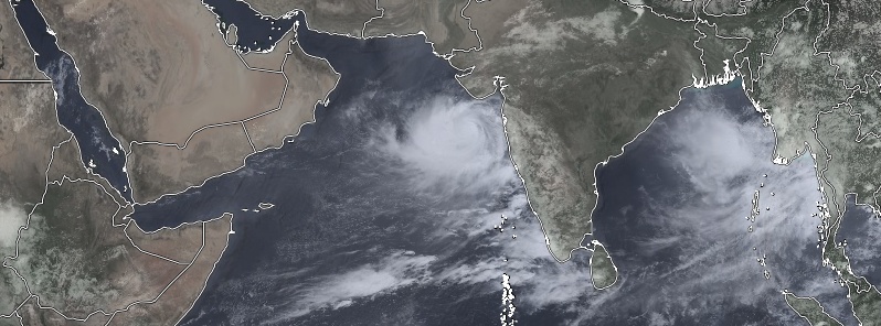
Featured image: Very Severe Cyclonic Storm "Vayu" at 07:00 UTC on June 12, 2019. Credit: UW-CIMSS, TW
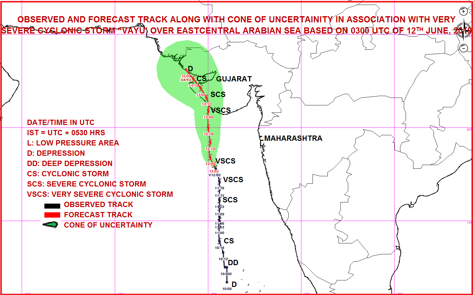
Nearly 300 000 people living in the path of Tropical Cyclone "Vayu" are set to be evacuated to 700 shelter homes, India's Home Ministry said Wednesday, June 12, 2019. Vayu is expected to cross Gujarat coast between Porbandar and Mahuva, around Veraval and Diu region, as a Very Severe Cyclonic Storm with wind speeds between 145 and 155 km/h (90 – 86 mph) and gusts to 170 km/h (105 mph) on the morning of June 13 (local time).
- Tropical cyclones of this strength are rare for the region.
- If the forecast verifies, this will be the strongest tropical cyclone to hit NW India since June 9, 1998, when 10 000 people lost their lives.
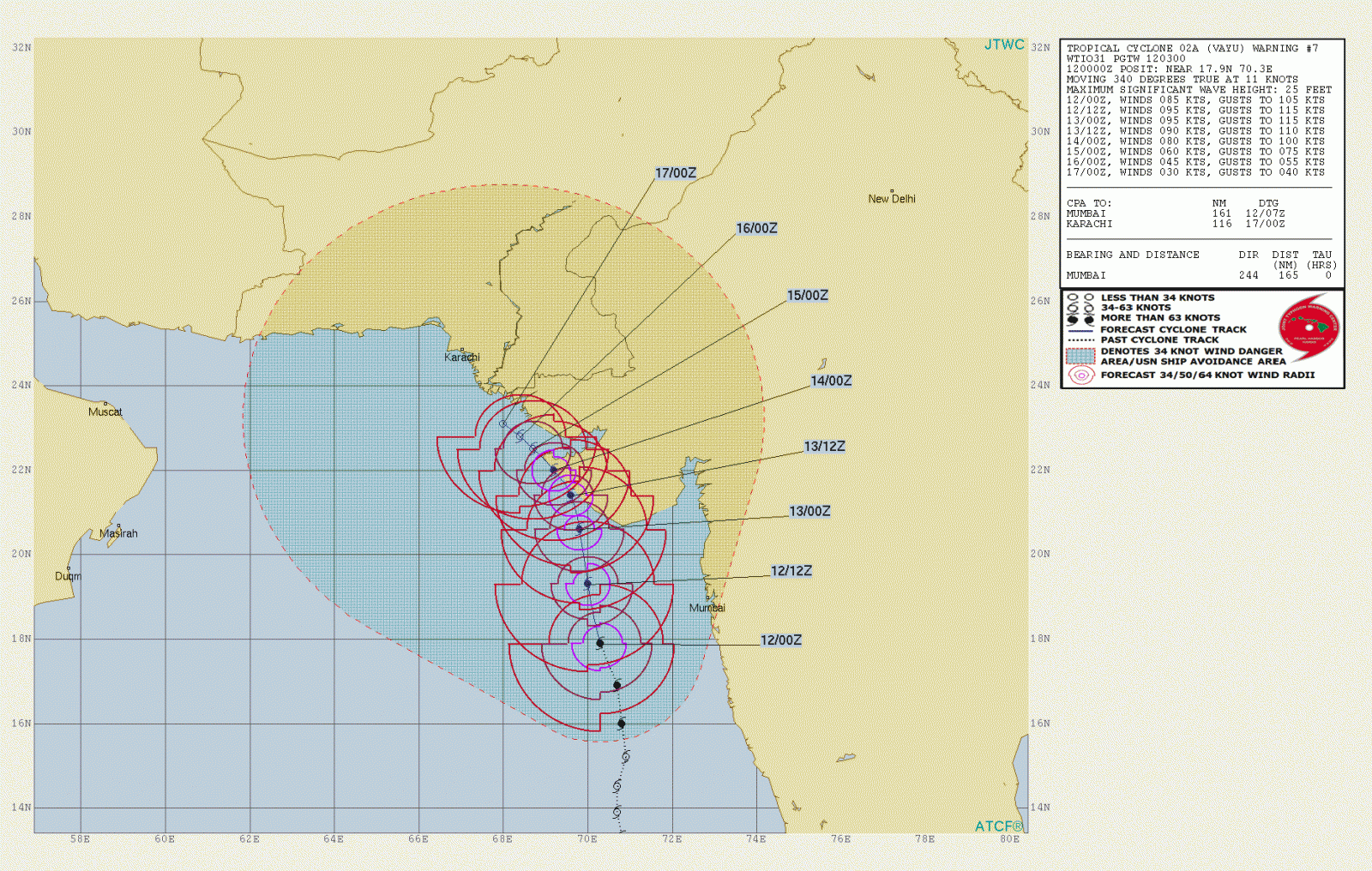
As of 00:00 UTC on June 12, the center of Very Severe Cyclonic Storm "Vayu" was located about 470 km (290 miles) WNW of Goa, 280 km (174 miles) SSW of Mumbai and 340 km (210 mph) S of Veraval, Gujarat, according to RSMC New Delhi.
Its estimated maximum sustained wind speed was 120 km/h (75 mph) with gusts to 140 km/h (85 mph). The estimated central pressure was 980 hPa.
Nearly 300 000 people are evacuating. All train services likely to be affected have been canceled and schools and colleges in affected districts closed until Friday.
The Gujarat tourism department has urged travelers, who have planned their visits in coming two-three days, to postpone.
Warnings in place
Wind warning
June 12: Wind speed is very likely to become gale wind speed reaching 135 – 145 km/h (84 – 90 mph) gusting to 160 km/h (100 mph) over east-central and adjoining northeast Arabian Sea by June 12. It is very likely to be 60 – 70 km/h (37 – 44 mph) gusting to 80 km/h (50 mph) over Gujarat Coast from the morning of June 12 and become gale wind speed reaching 145 – 155 km/h (90 – 96 mph) gusting to 170 km/h (105 mph) by the night. It is very likely to be 50 – 60 km/h (31 – 37 mph) gusting to 70 km/h (43 mph) over Maharashtra Coast.
June 13: Gale wind speed of the order of 145 – 155 km/h (90 – 96 mph) gusting to 170 km/h (105 mph) very likely over north Arabian Sea and Gujarat coast in morning hours and decrease gradually thereafter. It is very likely to be 50 – 60 km/h (31 – 37 mph) gusting to 70 km/h (43 mph) over north Maharashtra Coasts and northern parts of east-central Arabian Sea.
Sea condition
The sea condition is very likely to become very high to phenomenal over east-central and adjoining northeast Arabian Sea and Gujarat coast from June 12 and over the north Arabian Sea on June 13.
The Sea condition is very likely to very rough to high along and off Maharashtra Coast on June 12 and 13.
Fishermen Warning
The fishermen are advised not to venture into Eastcentral Arabian Sea and along and off Maharashtra Coast on 12th; northeast Arabian sea and along and off Gujarat coast on June 12 and 13.
Storm Surge Warning
Storm surge of height of about 1.5 – 2.0 m (4.9 – 6.5 feet) above the astronomical tides likely to inundate the low lying coastal areas of Kutch, Devbhoomi, Dwarka, Porbandar, Junagarh, Diu, Gir Somnath, Amreli and Bhavnagar districts at the time of landfall.
Damage Expected and Action suggested for Kutch, Devbhoomi Dwarka, Porbandar, Rajkot, Junagarh, Diu, Gir Somnath, Amreli and Bhavnagar districts of Gujarat:
Total destruction of thatched houses/extensive damage to Kutcha houses. Some damage to pucca houses. Potential threat from flying objects.
Bending/uprooting of power and communication poles.
Major damage to Kutcha and Pucca roads. Flooding of escape routes. Minor disruption of railways, overhead power lines and signaling systems.
Widespread damage to standing crops, plantation, orchards, falling of green coconuts and tearing of palm fronds. Blowing down bushy trees like mango.
Small boats, country crafts may get detached from moorings.
Visibility severe affected.
Action suggested:
Regulate road and rail traffic
Total suspension of fishing operations.
Evacuation from low lying areas of the above-mentioned districts, coastal Hutment dwellers, urban slum dwellers and people staying in unsafe house to safer places. People in affected areas to remain indoors.
Movement in motor boats and small ships unsafe.
Inundation of low lying areas in the along the coasts due to heavy rainfall and storm surge.
Very Severe Cyclonic Storm "Vayu" at 07:00 UTC on June 12, 2019. Credit: UW-CIMSS, TW
The last time Gujarat saw cyclone comparable to Vayu was back in 1998 when ARB 02 (Tropical Cyclone 03A) hit Gujarat near the city of Porbandar with winds of 193 km/h (120 mph). The cyclone produced storm surge up to 4.9 m (16 feet), causing great loss of life.
An estimated 10 000 people were killed and over 15 000 displaced.
Most of the dead were coastal salt mine workers and employees at the port of Kandla, India. The salt miners, who work along the coast trapping salt water and setting it up to evaporate in the sun, were killed when the large storm surge came ashore. Unfortunately, these people did not own radios to obtain proper warning of the approaching storm, and as a result, lost their lives.
Forecast models
I'm a dedicated researcher, journalist, and editor at The Watchers. With over 20 years of experience in the media industry, I specialize in hard science news, focusing on extreme weather, seismic and volcanic activity, space weather, and astronomy, including near-Earth objects and planetary defense strategies. You can reach me at teo /at/ watchers.news.
Commenting rules and guidelines
We value the thoughts and opinions of our readers and welcome healthy discussions on our website. In order to maintain a respectful and positive community, we ask that all commenters follow these rules.