
Eruptions continue at Bogoslof volcano, Aviation Color Code remains Red
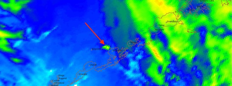
Featured image: Thermal infrared image showing the volcanic cloud produced by the eruption of Bogoslof volcano on July 2, 2017. Credit: JMA/Himawari-8, NOAA, CIMSS
Another powerful eruption occurred at Bogoslof volcano, Alaska at 20:48 UTC on July 2, 2017.
The latest eruption lasted 16 minutes and sent a cloud of ash up to 11 km (36 000 feet) that was carried easterly over northern Unalaska.
Observers in Dutch Harbor report no noticeable ash fall from today's eruption.
The Aviation Color Code remains at RED and the Alert Level remains at WARNING, the Alaska Volcano Observatory said 01:17 UTC, July 3. Additional ash-producing eruptions could occur at any time with no detectable precursors, AVO warns.
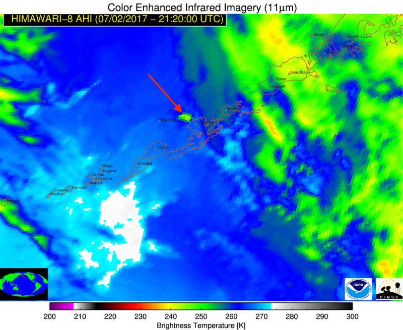
HIMAWARI-8 thermal infrared satellite image collected on July 2, 2017 at 21:20 UTC (13:20 AKDT) of the volcanic cloud (red arrow) produced by the eruption of Bogoslof volcano. The explosive eruption began about 20 minutes prior to this image, and by this time the volcanic cloud had moved towards the east. A pilot report suggested that the cloud may have reached an altitude of 11 km (36 000 feet) above sea level. The color scheme shows the temperature of the clouds in degrees Kelvin (Degrees Celsius+273). High clouds are cold (green-yellow-orange) and lower clouds are warm (blue-white).
Geological summary
Bogoslof is the emergent summit of a submarine volcano that lies 40 km (24.8 miles) north of the main Aleutian arc. It rises 1 500 m (4 920 feet) above the Bering Sea floor. Repeated construction and destruction of lava domes at different locations during historical time has greatly modified the appearance of this "Jack-in-the-Box" volcano and has introduced a confusing nomenclature applied during frequent visits of exploring expeditions.
The present triangular-shaped, 0.75 x 2 km (0.46 x 1.2 miles) island consists of remnants of lava domes emplaced from 1796 to 1992. Castle Rock (Old Bogoslof) is a steep-sided pinnacle that is a remnant of a spine from the 1796 eruption. Fire Island (New Bogoslof), a small island located about 600 m (1 970 feet) NW of Bogoslof Island, is a remnant of a lava dome that was formed in 1883. (GVP)
I'm a dedicated researcher, journalist, and editor at The Watchers. With over 20 years of experience in the media industry, I specialize in hard science news, focusing on extreme weather, seismic and volcanic activity, space weather, and astronomy, including near-Earth objects and planetary defense strategies. You can reach me at teo /at/ watchers.news.
Commenting rules and guidelines
We value the thoughts and opinions of our readers and welcome healthy discussions on our website. In order to maintain a respectful and positive community, we ask that all commenters follow these rules.