
Tropical Depression “Crising” to make landfall over Visayas, Philippines
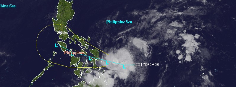
Featured image: Tropical Depression 02W (Crising) forecast track/VIS - April 14, 2017. Credit: UW-CIMSS
A newly developed Tropical Depression 02W, known in the Philippines as Crising, is heading toward the east coast of the eastern Visayas and is expected to make landfall by 09:00 UTC on Saturday, April 15, 2017. Although Crising will not reach tropical storm status, this system is a heavy rain maker and as such poses a risk to the affected region.
At 14:00 UTC (22:00 PHT) on April 14, Tropical Depression 02W was located 310 km (192 miles) east of Guiuan, Eastern Samar. It had maximum sustained winds of 45 km/h (28 mph) near the center and gusts up to 55 km/h (34.2 mph), according to PAGASA. The system is moving WNW at 20 km/h (12.4 mph).
The estimated rainfall amount is from moderate to occasionally heavy within the 250 km (155 miles) diameter of the system.
PAGASA said Crising is expected to make landfall over Samar island tomorrow afternoon (local time).
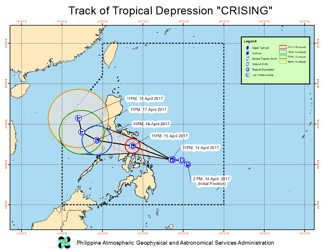
Tropical Depression "Crising" forecast track by PAGASA April 14, 2017
According to the JTWC, 02W had maximum winds of 37 km/h (23 mph) at 15:00 UTC today and was located 937 km (583 miles) ESE of Manila. The system is moving WNW at 20.3 km/h (12.6 mph) and is forecast to continue in that general direction.
JTWC expects Crising to make landfall along the east coast of the eastern Visayas by 09:00 UTC (17:00 PHT) on Saturday, April 15.
The center noted that the eastern side of the depression was already moving over Visayas today, April 14.
NHK meteorologist Robert Speta said the system gained an impressive amount of organization over the past 24 hours in the Philippine Sea (commonly known as the Philippine Sea Effect). "Although Crising is not expected to reach tropical storm status, we have seen in the past this far south in the Philippines even weak tropical depressions can cause problems."
"One of the deadlier storms in recent memory 'Washi' was just a tropical storm when it came on shore but still it resulted in mass casualties across northern Mindanao. I'm not saying this storm has that potential but just reminding you that these storms albeit small can still pack a punch," Speta warned.
I'm a dedicated researcher, journalist, and editor at The Watchers. With over 20 years of experience in the media industry, I specialize in hard science news, focusing on extreme weather, seismic and volcanic activity, space weather, and astronomy, including near-Earth objects and planetary defense strategies. You can reach me at teo /at/ watchers.news.
Commenting rules and guidelines
We value the thoughts and opinions of our readers and welcome healthy discussions on our website. In order to maintain a respectful and positive community, we ask that all commenters follow these rules.