
Significant storm system affecting northwestern US
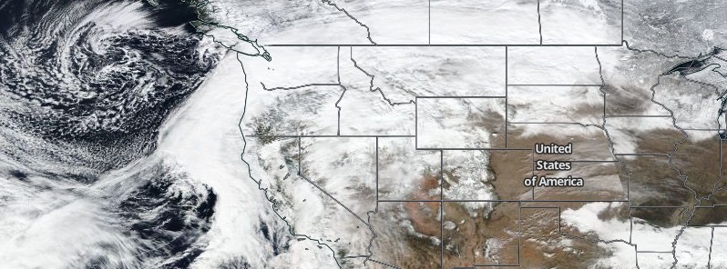
Featured image: Winter Storm "Maya" - US - February 5, 2017. Credit: NASA/NOAA/DoD Suomi NPP/VIIRS.
A significant storm system started impacting the northwestern United States on Sunday, February 5, 2017 and is expected to continue bringing heavy rain and mountain snow to much of the western US over the next several days.
An active weather pattern will continue across the western US over the next few days, as a strong surface low pressure system makes its way across the Intermountain West. Widespread mountain snow will continue from the Cascades to the central and northern Rockies, and mountain ranges in between. Total snowfall amounts between 0.3 and 0.6 m (1 – 2 feet) will be possible across the Sierra, Cascades, and Rockies through tonight, according to the National Weather Service.
Snowfall amounts less than one foot are expected elsewhere in the lower elevation mountains of the Pacific and Intermountain Northwest.
The greatest rainfall amounts are expected from central California to coastal Washington, where 76.2 mm (3 inches) to locally 152.4 mm (6 inches) of total rainfall will be possible through this evening, especially over upslope regions.
Winter Storm #Maya has been named. Snow to spread from Northwest to Upper Midwest and New England. https://t.co/Dumwl3vy07 pic.twitter.com/dl9btCdTXt
— The Weather Channel (@weatherchannel) February 5, 2017
Snow was first reported at Seattle-Tacoma International Airport Sunday morning. After a brief episode of rain, it turned to snow again by late afternoon. Oregon saw more than 50.8 mm (2 inches) of accumulated snow along its coastal areas by late Sunday afternoon.
NWS issued winter storm warnings for parts of western Washington, including Seattle, for the northern Cascades and coastal ranges of Oregon, California's Sierra Nevada, and parts of the northern Rockies. Winter weather advisories remain in effect for Oregon's northern Willamette Valley, including Portland.
A blizzard warning has been posted for a part of northwest Montana, where blowing and drifting snow is expected to create whiteout conditions.
730pm | Still snowing heavily along US26 between Timber Jct & the coast, Hwy 47 near Vernonia & US30 between St Helens, Rainier & Clatskanie pic.twitter.com/jhUBEztxgv
— NWS Portland (@NWSPortland) February 6, 2017
Another low pressure system is expected to eject eastward from the central Plains, strengthening as it combines with yet another low traveling across the north central US by Tuesday. As this system pushes northeastward and continues to gain strength, expect rain and thunderstorms to develop northward from the central Gulf Coast to the Ohio Valley and southern peripheries of the Great Lakes regions. Snow and mixed precipitation can be expected on the northern periphery of this low from Minnesota to northern New England.
Warm air will lift northward ahead of the surface low, bringing a warming trend for much of the East Coast to start out the work week. In fact, a few records may be matched or exceeded for both daily high temperatures as well as daily high minimum temperatures from the Southern Plains (Monday and Tuesday) to the East Coast (Wednesday), NWS said at 08:01 UTC (03:01 EST) on Monday, February 6, 2017.
The Watchers team and our contributors bring the latest on extreme weather, earthquakes, volcanic eruptions, space weather, and all things science. We're all about making sense of the natural world and keeping you informed on what’s happening. Got a tip or a question? Hit us up using the form at newstips!
Can you say, “weather manipulation”?