
Matthew bearing down on Haiti, claims first victims
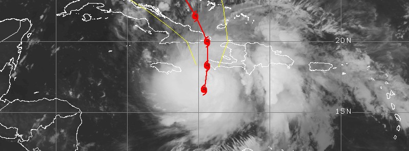
Featured image: Hurricane "Matthew" at 05:45 UTC on October 4, 2016. Credit: UW-CIMSS
The center of Category 4 Hurricane "Matthew" will pass directly over or very near southwestern Haiti around 12:00 UTC on October 4, 2016. Matthew has already claimed its first victims in Haiti, leaving at least two persons dead, authorities said Monday, October 3, 2016.
According to Marie Alta Jean-Baptiste, head of Haiti's civil protection agency, at least two fishermen died on Monday. A boat carrying one of the men capsized off the tiny southwestern fishing town of Saint Jean du Sud as he was trying to bring his wooden skiff to shore. The body of another was found off the nearby town of Aquin. Two more deaths were reported last week in Colombia and St. Vincent and the Grenadines.
More than 2 000 people were evacuated to temporary shelters in the Grand Sud region of Haiti by early evening yesterday. During the day, civil protection forces struggled with locals who refused to leave some of the most vulnerable areas, AFP's Amelie Baron reported from Port-au-Prince, Haiti.
"They included the extremely impoverished, densely populated neighborhoods of Cite Soleil – where some 100 000 of the total 500 000 residents face serious flooding risks – and the capital's Cite L'Eternel by the sea," she said adding that Cuba has evacuated some 316 000 people from the east of the island.
As of 06:00 UTC on October 4, the center of Hurricane "Matthew" was located about 270 km (165 miles) WSW of Port-au-Prince and 100 km (60 miles) S of Tiburon, Haiti, according to the NHC.
Matthew had maximum sustained winds of 230 km/h (145 mph) and gusts to 278 km/h (172 mph). It was moving north at 13 km/h (8 mph) with minimum estimated central pressure of 934 hPa.
On the current forecast track, Matthew's eye will pass near or over southwestern Haiti at 12:00 UTC today, approach and hit eastern Cuba about 12 hours later, and exit toward The Bahamas and Florida.
According to Philip Klotzbach, a meteorologist at CSU, the last Category 4 hurricane to make landfall in Haiti was Cleo in 1964.
Flooding was already reported in Jamaica, Haiti, and the Dominican Republic.
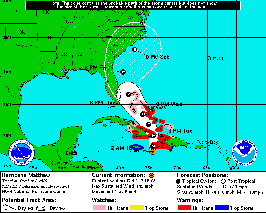
Hurricane Matthew forecast track by NHC at 06:00 UTC on October 4, 2016
Matthew is a dangerous Category 4 hurricane on the Saffir-Simpson Hurricane Wind Scale. Some fluctuations in intensity are possible during the next couple of days, but it is expected to remain a powerful hurricane through at least Thursday morning UTC, October 5, 2016.
Hurricane-force winds extend outward up to 65 km (40 miles) from the center and tropical-storm-force winds extend outward up to 295 km (185 miles).
Additionally, Matthew is approaching the islands while dumping extreme amounts of rain. Life-threatening flash floods and mudslides are likely in southern and northwestern Haiti and the southwestern Dominican Republic, NHC warns.
Matthew is expected to produce total rain accumulations of 381 to 635 mm (15 to 25 inches) across southern Haiti and the southwestern portion of the Dominican Republic, with possible isolated amounts of 1 016 mm (40 inches).
Across eastern Cuba and western Haiti, total rain accumulations of 203 to 305 mm (8 to 12 inches) are expected with possible isolated maximum amounts of 508 mm (20 inches).
Total rainfall of 127 to 254 mm (5 to 10 inches) is expected across eastern Jamaica, with isolated maximum amounts of 381 – 507 mm (15 – 20 inches) possible.
Video courtesy Breaking Disaster
Video courtesy StormChasingVideo
Update
12:56 UTC
The eye of extremely dangerous Category 4 Hurricane "Matthew" has made landfall near Les Anglais in western Haiti at 11:00 UTC on October 4, 2016.
At the time of the landfall, Matthew had maximum sustained winds of 230 km/h (145 mph) and gusts to 278 km/h (172 mph).
At 12:00 UTC, its center was located 15 km (9.3 miles) E of Tiburon, Haiti and 200 km (125 miles) S of the eastern tip of Cuba. Matthew's minimum estimated pressure is 934 hPa.
Matthew is moving toward the north near 15 km/h (9.3 mph), and this general motion is expected to continue today.
The system will exit Haiti around 13:00 UTC and be on its way toward eastern Cuba.
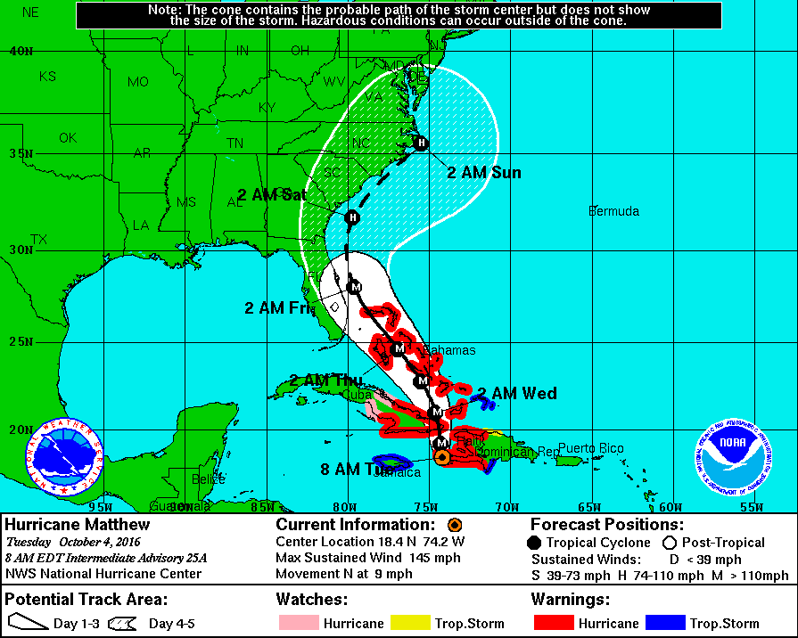
Hurricane "Matthew" forecast track by NHC at 12:00 UTC on October 4, 2016
Read more: Hurricane "Matthew" summary: data, images and videos – September/October 2016
The Watchers team and our contributors bring the latest on extreme weather, earthquakes, volcanic eruptions, space weather, and all things science. We're all about making sense of the natural world and keeping you informed on what’s happening. Got a tip or a question? Hit us up using the form at newstips!
Commenting rules and guidelines
We value the thoughts and opinions of our readers and welcome healthy discussions on our website. In order to maintain a respectful and positive community, we ask that all commenters follow these rules.