
Very shallow M5.2 earthquake, numerous aftershocks registered near Borrego Springs, Southern California
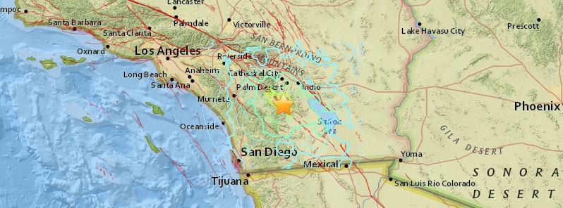
Image credit: USGS
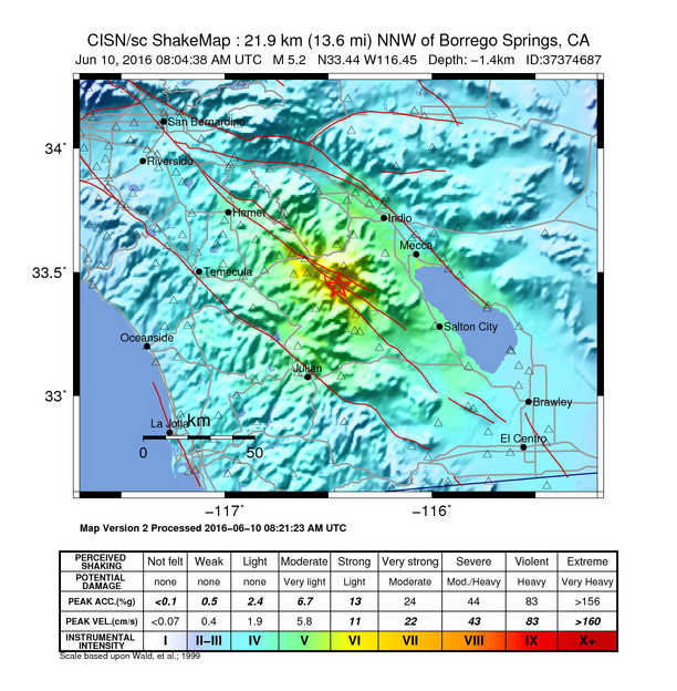
A very shallow earthquake registered by the USGS as M5.2 hit near Borrego Springs, Southern California, US at 08:04 UTC (01:04 local time) on June 10, 2016. Almost 400 small to moderate aftershocks were reported by 13:23 UTC. Four of them had magnitudes 2.8 and above. EMSC reports Mw5.1 at a depth of 1 km (0.62 miles).
The epicenter was located near the San Jacinto fault, 22 km (13.7 miles) NNW of Borrego Springs, 24 km (14.9 miles) ESE of Anza, 25 km (15.5 miles) NE of Warner Springs, 43 km (26.7 miles) S of Palm Springs, 68 km (42.3 miles) ENE of Escondido, 98 km (60.9 miles) NE of San Diego, and 109 km (67.7 miles) SE of San Bernardino, California, US.
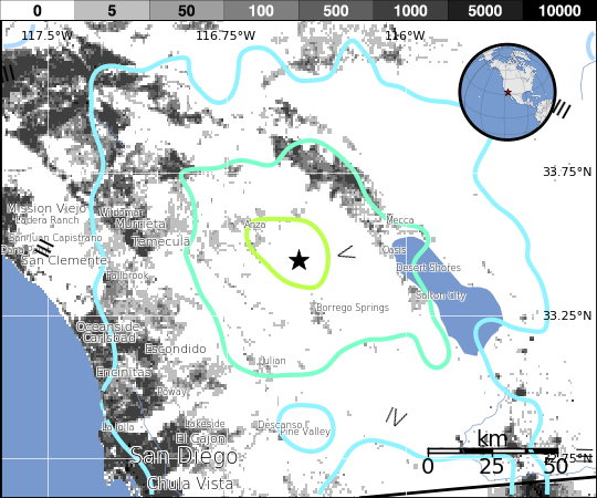
There are about 20 million people in the felt area.
Residents reported feeling the earthquake in Los Angeles and Orange counties, and the Inland Empire.
According to USGS seismologist Dr. Lucy Jones, San Jacinto is historically most active fault in Southern California. "Today's earthquake is near locations of M6 in 1937 and M5.3 in 1980," Jones said.
Impressive ! Earthquake eyewitnesses reach EMSC website within seconds #California #riverside pic.twitter.com/RCVgANH5CV
— EMSC (@LastQuake) June 10, 2016
USGS issued a green alert for shaking-related fatalities and economic losses. There is a low likelihood of casualties and damage.
Overall, the population in this region resides in structures that are highly resistant to earthquake shaking, though some vulnerable structures exist.
Recent earthquakes in this area have caused secondary hazards such as landslides and liquefaction that might have contributed to losses.
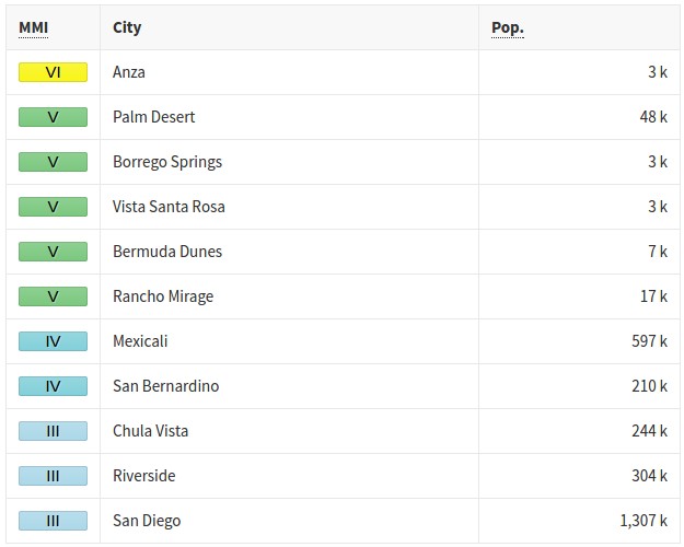
Estimated population exposure to earthquake shaking
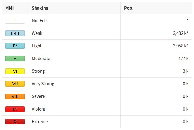
*Estimated exposure only includes population within map area (k = x1,000)
Modified Mercalli Intensity (MMI) scale
Selected cities exposed
Between 15:31 UTC on June 9 and 08:48 UTC on June 10, USGS registered 86 earthquakes in this region.
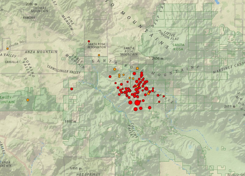
Image credit: USGS
- 1.32016-06-10 08:46:36 UTC12.1 km
- 1.12016-06-10 08:46:31 UTC2.9 km
- 1.42016-06-10 08:45:55 UTC10.6 km
- 1.12016-06-10 08:45:30 UTC10.9 km
- 0.52016-06-10 08:44:53 UTC11.0 km
- 1.42016-06-10 08:44:19 UTC10.2 km
- 0.52016-06-10 08:43:48 UTC-0.1 km
- 1.32016-06-10 08:43:23 UTC11.1 km
- 1.02016-06-10 08:43:08 UTC11.3 km
- 1.02016-06-10 08:41:53 UTC8.8 km
- 0.92016-06-10 08:40:55 UTC13.0 km
- 1.02016-06-10 08:40:48 UTC10.7 km
- 1.22016-06-10 08:40:28 UTC10.3 km
- 2.02016-06-10 08:39:48 UTC11.2 km
- 0.62016-06-10 08:39:31 UTC10.7 km
- 1.02016-06-10 08:39:10 UTC12.6 km
- 0.62016-06-10 08:39:00 UTC1.4 km
- 2.02016-06-10 08:37:24 UTC11.4 km
- 0.72016-06-10 08:37:08 UTC12.5 km
- 1.02016-06-10 08:36:49 UTC13.8 km
- 1.02016-06-10 08:36:33 UTC12.6 km
- 1.22016-06-10 08:36:18 UTC11.9 km
- 1.22016-06-10 08:36:14 UTC11.5 km
- 1.02016-06-10 08:35:58 UTC11.1 km
- 1.72016-06-10 08:35:55 UTC10.0 km
- 0.92016-06-10 08:35:40 UTC11.3 km
- 3.52016-06-10 08:33:57 UTC10.4 km
- 1.62016-06-10 08:32:18 UTC10.7 km
- 1.52016-06-10 08:31:30 UTC12.3 km
- 1.52016-06-10 08:31:21 UTC10.8 km
- 2.02016-06-10 08:30:46 UTC10.0 km
- 1.82016-06-10 08:30:07 UTC8.9 km
- 0.82016-06-10 08:29:31 UTC11.4 km
- 1.32016-06-10 08:28:25 UTC9.3 km
- 1.02016-06-10 08:28:15 UTC7.6 km
- 0.72016-06-10 08:27:40 UTC4.6 km
- 1.22016-06-10 08:27:08 UTC9.4 km
- 0.72016-06-10 08:26:59 UTC4.8 km
- 0.92016-06-10 08:26:23 UTC11.9 km
- 0.62016-06-10 08:26:07 UTC12.3 km
- 0.72016-06-10 08:25:17 UTC12.0 km
- 1.02016-06-10 08:24:26 UTC12.5 km
- 0.92016-06-10 08:24:06 UTC12.1 km
- 1.22016-06-10 08:23:11 UTC10.1 km
- 1.42016-06-10 08:21:30 UTC11.4 km
- 1.92016-06-10 08:20:33 UTC11.1 km
- 2.22016-06-10 08:20:19 UTC11.6 km
- 0.72016-06-10 08:19:44 UTC-0.1 km
- 2.12016-06-10 08:18:31 UTC12.0 km
- 0.92016-06-10 08:18:24 UTC12.6 km
- 1.32016-06-10 08:17:41 UTC5.2 km
- 2.02016-06-10 08:17:07 UTC9.8 km
- 1.42016-06-10 08:17:03 UTC12.5 km
- 1.62016-06-10 08:16:46 UTC10.6 km
- 1.22016-06-10 08:16:24 UTC9.1 km
- 1.12016-06-10 08:16:07 UTC12.4 km
- 1.32016-06-10 08:15:07 UTC10.1 km
- 1.12016-06-10 08:14:42 UTC11.1 km
- 1.12016-06-10 08:14:22 UTC12.3 km
- 1.02016-06-10 08:14:13 UTC10.3 km
- 1.82016-06-10 08:13:05 UTC11.8 km
- 1.22016-06-10 08:12:48 UTC12.1 km
- 1.62016-06-10 08:12:02 UTC11.7 km
- 1.92016-06-10 08:11:40 UTC11.3 km
- 2.02016-06-10 08:11:21 UTC12.1 km
- 2.02016-06-10 08:11:06 UTC11.3 km
- 2.42016-06-10 08:10:34 UTC12.6 km
- 1.82016-06-10 08:10:22 UTC10.7 km
- 2.02016-06-10 08:10:03 UTC12.8 km
- 2.42016-06-10 08:09:21 UTC11.1 km
- 2.12016-06-10 08:09:11 UTC11.8 km
- 2.12016-06-10 08:08:28 UTC6.5 km
- 2.82016-06-10 08:07:33 UTC12.0 km
- 3.02016-06-10 08:07:11 UTC12.3 km
- 3.52016-06-10 08:06:22 UTC10.8 km
- 5.22016-06-10 08:04:38 UTC-1.4 km
- 1.12016-06-10 06:22:59 UTC14.2 km
- 0.12016-06-10 06:09:40 UTC8.7 km
- 0.92016-06-10 06:08:22 UTC12.0 km
- 0.52016-06-10 06:08:08 UTC-0.4 km
- 0.52016-06-10 06:08:01 UTC11.9 km
- 0.52016-06-10 02:21:41 UTC10.3 km
- 1.12016-06-09 22:32:46 UTC1.1 km
- 1.12016-06-09 20:37:07 UTC13.9 km
- 1.32016-06-09 20:09:08 UTC6.7 km
- 1.12016-06-09 17:19:30 UTC11.5 km
- 0.52016-06-09 17:00:31 UTC14.0 km
- 0.72016-06-09 16:30:14 UTC17.8 km
- 0.82016-06-09 15:31:04 UTC14.3 km
The Watchers team and our contributors bring the latest on extreme weather, earthquakes, volcanic eruptions, space weather, and all things science. We're all about making sense of the natural world and keeping you informed on what’s happening. Got a tip or a question? Hit us up using the form at newstips!
Commenting rules and guidelines
We value the thoughts and opinions of our readers and welcome healthy discussions on our website. In order to maintain a respectful and positive community, we ask that all commenters follow these rules.