
Severe weather hits US Midwest with heavy rain, very large hail and tornadoes

Image credit: Jacob Dickey / Live Storms Media
First significant severe weather event of the year has hit the US Midwest on March 15 and 16, 2016, bringing heavy rain, damaging wind gusts, very large hail and tornadoes.
As the day progresses, a storm system moving through the Upper Midwest will bring strong winds to the Midwest along with heavy snow to portions of Minnesota, Wisconsin and the U.P. of Michigan. Winter Storm Warnings are in effect for parts of these states. High Wind Warnings and Wind Advisories are in effect for other parts of the Midwest, NWS said.

Weather forecast for Wednesday, March 16, 2016, issued 07:53 UTC.
According to the Storm Prediction Center, there were 11 tornado reports, most of them in Illinois, and 58 hail reports (golf ball size and up to 5.7 cm (2.25 inches), on March 15/16.

| Tornado reports (all times UTC) | |||||
|---|---|---|---|---|---|
| Time | Location | County | State | Comments | |
| 22:52 | 3 SE WARSAW | HANCOCK | IL | TORNADO OBSERVED 2 TO 3 MILES SOUTHEAST OF WARSAW AT CORNER OF HIGHWAY 11 AND 136. IT HAS LIFTED … .WAS A HIGH BASED CONE WITH A SMALL DEBRIS FIELD FOR A BIT. (DVN) | |
| 23:23 | 2 W GOOD HOPE | MCDONOUGH | IL | TORNADO SPOTTED. (DVN) | |
| 23:30 | NE GOOD HOPE | MCDONOUGH | IL | NUMEROUS REPORTS OF A TORNADO BETWEEN GOOD HOPE AND BUSHNELL ALONG ROUTE 9. (DVN) | |
| 23:30 | 1 SW RAPIDS CITY | ROCK ISLAND | IL | TORNADO SPOTTED SOUTH OF LE CLAIRE (DVN) | |
| 23:38 | 4 NNW SCOTTSBURG | MCDONOUGH | IL | TORNADO SPOTTED. (DVN) | |
| 23:38 | 4 NNE GOOD HOPE | MCDONOUGH | IL | (DVN) | |
| 00:29 | 1 SW RAPIDS CITY | ROCK ISLAND | IL | TORNADO SPOTTED SOUTH OF LE CLAIRE (DVN) | |
| 00:46 | 3 NNE TRIVOLI | PEORIA | IL | SIGNIFICANT DAMAGE TO A CHURCH AND LARGE TREES SNAPPED. NEAR TEXAS RD AND COTTONWOOD RD.(ILX) | |
| 00:47 | LOAMI | SANGAMON | IL | (ILX) | |
| 00:47 | 4 WSW CLINTON | CLINTON | IA | MOBILE HOMES BLOWN OVER. (DVN) | |
| 00:50 | 4 N HANNA CITY | PEORIA | IL | HOUSE DAMAGED … ROOF BLOWN OFF (ILX) | |

Video courtesy Live Storms Media

Video courtesy Storm Chasing Video

Video courtesy Live Storms Media
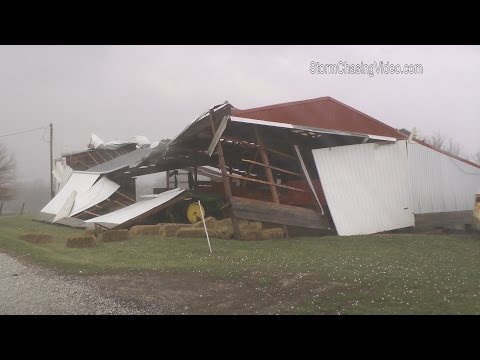
Video courtesy Storm Chasing Video

Video courtesy Alec Scholten

Video courtesy Storm Chasing Video

Teo Blašković founded The Watchers in 2011 and edited it until 2026, covering seismic and volcanic activity, extreme weather, space weather and near-Earth objects. Articles on this page are his archive.
Earlier reporting
Nothing on Watchers was published in the last 24 hours. These are older articles.
- CPC posts a slight risk of heavy rain from the Gulf Coast to the Northeast urban corridor November 25-29, and a moderate risk of West Coast wind and Sierra snow on November 25
- The storms drenching California this week are fed by a river in the sky, a band of water vapor that can carry up to 15 times the flow of the Mississippi River, and this winter’s near-record El Niño could keep aiming more of them at the West Coast
- Atmospheric river brings moderate risk of heavy rain, mountain snow and high winds to northern California and southwest Oregon on November 24-25
- 190 mm of rain and 131 km/h gusts hit New Zealand's South Island, flooding West Coast highways

YOU GUYS ROCK !!!!! keep up the good work !
Thanks!! Sure!