
Massive M8.3 earthquake hits near the coast of Chile, tsunami observed, strong aftershocks reported
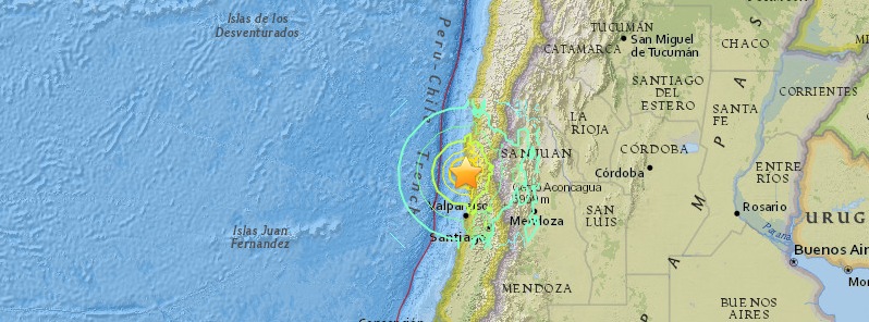
Image credit: USGS
A massive earthquake registered as M8.3 by USGS hit near the coast of Chile at 22:54 UTC on September 16, 2015. The ageny is reporting a depth of 25.0 km (15.5 miles). CSN Chile is reporting M7.8 at a depth of 11.1 km (6.9 miles). Tsunami waves have been observed. Strong aftershocks are being reported.
Jump to: Updates, Aftershocks (opens in new page)
According to the USGS, epicenter was located 46 km (29 miles) W of Illapel, 68 km (42 miles) WNW of Salamanca, 104 km (65 miles) NNW of La Ligua, 116 km (72 miles) SSW of Ovalle and 228 km (142 miles) NNW of Santiago, Chile.
There are about 131 936 people living within 100 km (62 miles) radius.
Strong shaking lasted for several minutes, as visible in the video recorded in Santiago, 228 km (142 miles) from the epicenter:
Based on the preliminary earthquake parameters, widespread hazardous tsunami waves are possible, PTWC said at 23:00 UTC.
Tsunami waves reaching more than 3 meters (9.8 feet) above the tide level are possible along some coasts of Chile. Waves reaching 0.3 – 1 meters (1 – 3.3 feet) above the tide level are possible for some coasts of Ecuador and Peru, PTWC said at 23:23 UTC.
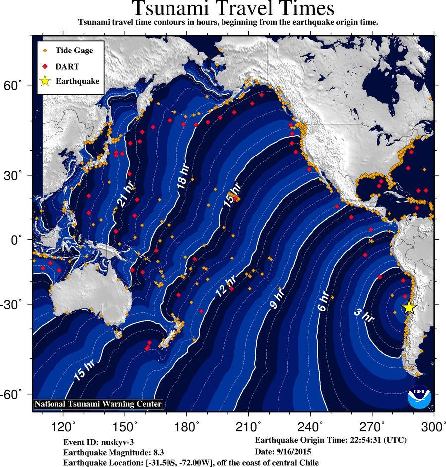
Tsunami travel time forecast. Image credit: NTWC.
Chile's government urged residents to evacuate the coastline.
USGS issued yellow alert level for shaking-related fatalities. Some casualties are possible.
Orange alert level was issued for economic losses. Significant damage is likely and the disaster is potentially widespread. Estimated economic losses are less than 1% of GDP of Chile. Past events with this alert level have required a regional or national level response.
Overall, the population in this region resides in structures that are resistant to earthquake shaking, though some vulnerable structures exist. The predominant vulnerable building types are low-rise reinforced/confined masonry and adobe block construction.
Recent earthquakes in this area have caused secondary hazards such as tsunamis, landslides, and liquefaction that might have contributed to losses.
At 00:23 UTC, PTWC said that tsunami waves reaching 0.3 to 1 meters above the tide level are possible for some coasts of: Mexico, Ecuador, Peru, Antarctica, Japan, New Caledonia, New Zealand, Marshall Islands, Fiji, Samoa, American Samoa, Cook Islands, Tokelau, Vanuatu, Kiribati, Johnston Island, Palmyra Island, Howland and Baker, Tonga, Wallis and Futuna, Pitcairn Islands, Niue, Solomon Islands, Russia, Hawaii and NW Hawaiian islands.
Tsunami waves are forecast to be less than 0.3 meters above the tide level for the coasts of: El Salvator, Guatemala, Honduras, Costa Rica, Nicaragua, Panama, Colombia, Australia, Philippines, Taiwan, China, Northern Marianas, Guam, Palau, Yap, Pohnpei, Chuuk, Kosarae, Nauru, Wake Island, Midway Island, Jarvis Island, Tuvalu, Papua New Guinea, Indonesia, Vietnam, Malaysia and Brunei.
.jpg)
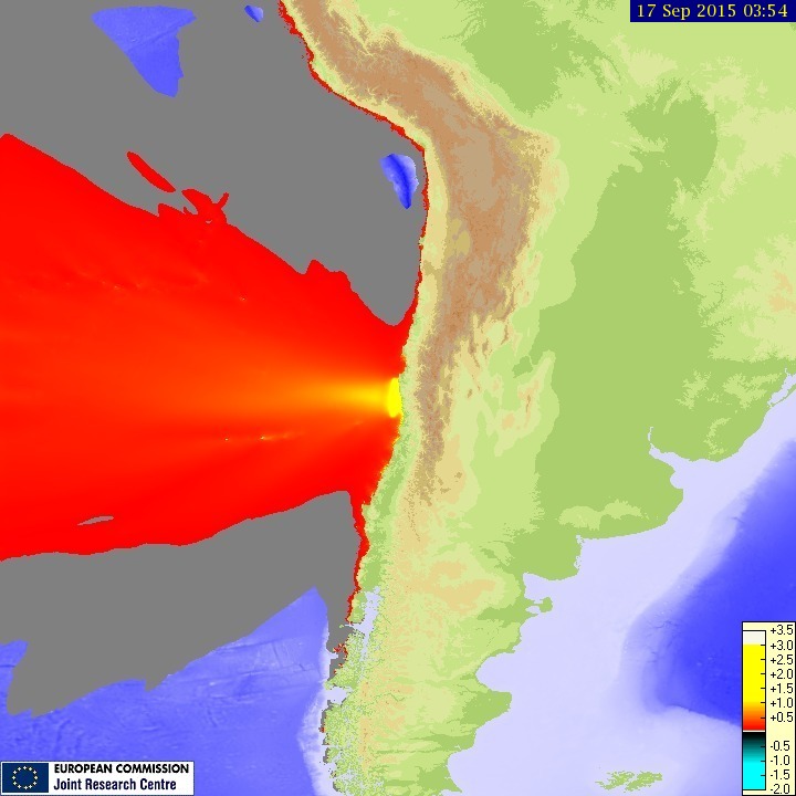
Tsunami maximum wave height. See animation. Image credit: JRC.
EMSC's 'I-felt-it' reports mention a two to five+ minutes shaking.
One EMSC reader, from Farellones, Chile (located 231 km SE from epicenter) said: "In contrast to other earthquakes, which are regular in Santiago, this one felt very irregular and aperiodic. It lasted long as well, continuously going into aftershocks."
Professor Max Wyss, who specializes in theoretical prognoses of injuries and fatalities expects: 10 to 100 fatalities and 100 to 1000 injured, ER reported at 00:16 UTC on September 17.
8.3 quake #Chile #Tsunami wave of 15.1 feet hit Coquimbo, Chile Street in Concon, Chile, reportedly flooded pic.twitter.com/6KvJEWicqq
— Alexander Hansen (@AlexanderXV) September 17, 2015
#ALERTA: Terremoto de 7.9 grados sacudió a #Chile y activó las alertas de #Tsunami http://t.co/D8K10ElHrV pic.twitter.com/IB21TW4pKz
— RefereeMX (@Referee_Mx) September 17, 2015
#chile is shaken up by 8.3 quake #tsunami alert issued for #hawaii http://t.co/sPFXdLgZbt RT pic.twitter.com/YXu0iYogm4
— RainApp Social (@rainappsocial) September 17, 2015
Updates
13:40 UTC, September 21:
– The death toll rose to 13.
23:30 UTC, September 17:
– Chilean authorities said at least 11 people have died as a result of earthquake-related incidents.
Earthquake-Report update at 10:33 UTC, September 17:
– "Carlos Robles, our Mexican volunteer compiled the situation in various locations:"
Argentina:
-Buenos Aires: People auto-evacuated buildings and universities.
-Rosario: One maternity hospital was briefly evacuated.
-San Rafael: Phone communications were overwhelmed and collapsed.
-Catamarca: One monument suffered a crack.
Chile:
Region of Los Rios:
* 1,500 people evacuated from costal regions,
* Max. sea variation of 20 c.m.
* School suspended.
Region of Araucania:
– Coastal regions:
* 6,000 people evacuated, * School suspended.
– (CITY) Temuco:
* Power outages affected 750 people., Gas stations were emptied, School suspended.
– (CITY) Tolten:
* 52 families in shelters.
Region of Bio Bio:
Coastal regions: School suspended.
Finally, Carlos complied the available VIDEOS of the Chile earthquake
04:00 UTC, September 17:
– officials confirmed the death of five people and the disappearance of one more. In addition, there are a million evacuees and 240 000 households without power.
Tectonic summary
According to the USGS, the September 16, 2015 M8.3 earthquake west of Illapel, Chile, occurred as the result of thrust faulting on the interface between the Nazca and South America plates in Central Chile. At the latitude of this event, the Nazca plate is moving towards the east-northeast at a velocity of 74 mm/yr with respect to South America, and begins its subduction beneath the continent at the Peru-Chile Trench, 85 km to the west of the September 16 earthquake. The size, location, depth and mechanism of this event are all consistent with its occurrence on the megathrust interface in this region.
While commonly plotted as points on maps, earthquakes of this size are more appropriately described as slip over a larger fault area. Events of the size of the September 16, 2015 earthquake are typically about 230×100 km in size (length x width).
Chile has a long history of massive earthquakes, including the 2010 M8.8 Maule earthquake in central Chile, which ruptured a ~400 km long section of the plate boundary south of this 2015 event (and to the south of the Juan Fernandez Ridge, which enters the trench immediately south of the 2015 earthquake). This subducton zone also hosted the largest earthquake on record, the 1960 M9.5 earthquake in southern Chile. Over the century prior to the September 16, 2015 earthquake, the region within 400 km of this event has hosted 15 other M7+ earthquakes.
Aftershocks
As of 23:16 UTC on September 16, all agencies are reporting strong aftershocks. By September 21 at 13:30 UTC, USGS registered a total of 161 earthquakes in the region, including the M8.3:
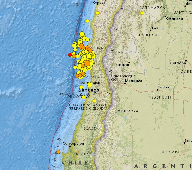
Image credit: USGS
- 4.92015-09-21 12:49:23 UTC20.5 km
- 4.42015-09-21 12:35:50 UTC42.0 km
- 4.72015-09-21 10:13:09 UTC41.5 km
- 4.42015-09-21 07:18:37 UTC30.3 km
- 4.72015-09-21 05:50:55 UTC10.0 km
- 6.32015-09-21 05:39:33 UTC22.8 km
- 4.22015-09-21 05:30:22 UTC10.0 km
- 4.32015-09-21 03:17:12 UTC12.6 km
- 4.22015-09-21 03:03:31 UTC12.3 km
- 4.22015-09-21 02:24:53 UTC21.6 km
- 4.82015-09-20 20:29:09 UTC16.9 km
- 4.92015-09-20 17:18:27 UTC30.7 km
- 4.22015-09-20 15:46:48 UTC9.3 km
- 4.12015-09-20 15:38:48 UTC10.0 km
- 4.72015-09-20 14:31:08 UTC25.1 km
- 4.52015-09-20 12:36:49 UTC22.4 km
- 4.52015-09-20 09:57:09 UTC12.9 km
- 4.22015-09-20 09:20:04 UTC5.0 km
- 5.22015-09-20 09:02:33 UTC16.7 km
- 4.72015-09-20 06:55:48 UTC28.1 km
- 4.42015-09-20 06:49:10 UTC29.5 km
- 5.22015-09-20 06:07:03 UTC17.0 km
- 4.42015-09-20 04:22:03 UTC21.6 km
- 5.42015-09-20 03:02:01 UTC34.3 km
- 4.62015-09-20 01:34:35 UTC10.0 km
- 4.72015-09-20 01:18:49 UTC10.0 km
- 4.12015-09-20 01:12:35 UTC10.0 km
- 4.32015-09-20 00:59:23 UTC18.5 km
- 4.32015-09-20 00:48:17 UTC17.5 km
- 4.02015-09-20 00:10:26 UTC27.8 km
- 4.02015-09-19 23:21:24 UTC14.6 km
- 4.42015-09-19 23:16:34 UTC10.0 km
- 4.42015-09-19 22:59:40 UTC45.0 km
- 4.22015-09-19 20:41:19 UTC10.2 km
- 4.32015-09-19 20:39:39 UTC7.0 km
- 4.52015-09-19 19:09:03 UTC19.0 km
- 4.72015-09-19 18:13:17 UTC30.3 km
- 4.52015-09-19 15:24:57 UTC26.0 km
- 4.52015-09-19 15:02:17 UTC16.3 km
- 4.52015-09-19 13:58:26 UTC22.0 km
- 5.62015-09-19 13:08:57 UTC14.1 km
- 6.22015-09-19 12:52:19 UTC10.6 km
- 4.72015-09-19 11:32:08 UTC7.9 km
- 4.32015-09-19 10:46:04 UTC70.2 km
- 4.62015-09-19 09:48:45 UTC19.3 km
- 4.72015-09-19 09:42:00 UTC16.6 km
- 5.72015-09-19 09:07:09 UTC28.0 km
- 5.32015-09-19 08:31:24 UTC6.9 km
- 4.92015-09-19 06:27:10 UTC10.0 km
- 4.52015-09-19 05:55:26 UTC38.4 km
- 5.82015-09-19 05:06:47 UTC10.0 km
- 4.52015-09-19 05:01:41 UTC10.0 km
- 4.22015-09-19 04:44:12 UTC51.5 km
- 4.92015-09-19 04:33:48 UTC20.0 km
- 4.62015-09-19 04:12:46 UTC17.1 km
- 4.32015-09-19 03:14:18 UTC20.4 km
- 5.02015-09-19 02:49:40 UTC19.8 km
- 4.62015-09-19 01:19:22 UTC17.3 km
- 4.42015-09-19 00:31:27 UTC14.7 km
- 4.22015-09-18 23:50:44 UTC9.5 km
- 4.12015-09-18 23:30:55 UTC10.0 km
- 4.72015-09-18 22:35:20 UTC10.0 km
- 4.92015-09-18 22:12:16 UTC11.2 km
- 4.52015-09-18 19:54:45 UTC18.8 km
- 4.92015-09-18 19:41:59 UTC28.8 km
- 4.62015-09-18 19:25:35 UTC10.0 km
- 4.42015-09-18 19:18:06 UTC10.0 km
- 4.72015-09-18 18:20:07 UTC63.0 km
- 4.72015-09-18 18:15:29 UTC15.6 km
- 4.12015-09-18 17:27:16 UTC20.2 km
- 4.42015-09-18 16:00:31 UTC15.0 km
- 4.52015-09-18 15:58:37 UTC35.0 km
- 4.82015-09-18 14:59:43 UTC33.9 km
- 4.82015-09-18 14:08:08 UTC35.0 km
- 4.92015-09-18 13:51:18 UTC27.8 km
- 4.82015-09-18 10:21:45 UTC10.0 km
- 6.32015-09-18 09:10:44 UTC8.7 km
- 5.12015-09-18 08:18:18 UTC10.0 km
- 4.72015-09-18 07:49:15 UTC13.1 km
- 4.82015-09-18 07:44:10 UTC39.4 km
- 4.52015-09-18 05:33:38 UTC43.0 km
- 4.82015-09-18 05:27:39 UTC11.5 km
- 5.02015-09-18 04:29:05 UTC24.2 km
- 5.42015-09-18 04:24:02 UTC10.0 km
- 5.02015-09-18 03:32:18 UTC15.1 km
- 5.02015-09-18 03:15:40 UTC31.4 km
- 4.72015-09-18 03:14:54 UTC29.5 km
- 4.42015-09-18 02:58:42 UTC30.8 km
- 4.82015-09-18 01:50:22 UTC21.1 km
- 4.22015-09-18 01:29:48 UTC19.4 km
- 4.52015-09-18 01:11:37 UTC22.6 km
- 4.22015-09-18 00:39:04 UTC30.1 km
- 4.42015-09-18 00:10:06 UTC6.0 km
- 4.82015-09-17 23:55:00 UTC11.7 km
- 4.52015-09-17 23:35:01 UTC10.0 km
- 4.22015-09-17 23:23:14 UTC15.4 km
- 5.12015-09-17 22:39:20 UTC21.3 km
- 4.92015-09-17 22:08:04 UTC9.3 km
- 4.12015-09-17 21:21:00 UTC32.4 km
- 5.42015-09-17 20:40:31 UTC4.7 km
- 4.72015-09-17 20:24:35 UTC16.6 km
- 4.42015-09-17 20:24:13 UTC10.0 km
- 4.42015-09-17 19:11:18 UTC4.3 km
- 4.62015-09-17 18:51:58 UTC10.5 km
- 4.92015-09-17 18:26:40 UTC4.5 km
- 4.52015-09-17 18:04:41 UTC12.8 km
- 4.42015-09-17 17:58:29 UTC42.4 km
- 4.72015-09-17 17:32:21 UTC28.2 km
- 4.42015-09-17 17:17:52 UTC17.4 km
- 4.82015-09-17 17:02:12 UTC9.6 km
- 5.32015-09-17 16:52:17 UTC10.0 km
- 4.82015-09-17 16:46:21 UTC10.1 km
- 4.12015-09-17 16:32:38 UTC23.9 km
- 5.32015-09-17 16:08:35 UTC35.0 km
- 4.62015-09-17 15:00:34 UTC10.1 km
- 4.72015-09-17 14:35:02 UTC10.0 km
- 5.52015-09-17 14:19:15 UTC10.0 km
- 5.42015-09-17 13:32:26 UTC10.0 km
- 5.32015-09-17 12:14:34 UTC10.0 km
- 5.32015-09-17 12:09:44 UTC11.2 km
- 5.52015-09-17 10:31:26 UTC42.5 km
- 5.12015-09-17 10:12:52 UTC10.0 km
- 5.12015-09-17 08:32:40 UTC10.0 km
- 4.72015-09-17 07:55:56 UTC18.6 km
- 5.02015-09-17 07:28:00 UTC10.0 km
- 4.82015-09-17 07:18:57 UTC25.9 km
- 4.82015-09-17 07:01:01 UTC18.8 km
- 4.92015-09-17 06:38:56 UTC25.0 km
- 4.72015-09-17 06:20:30 UTC30.8 km
- 4.72015-09-17 05:57:11 UTC15.6 km
- 5.52015-09-17 05:44:39 UTC10.0 km
- 5.22015-09-17 05:40:58 UTC9.3 km
- 4.82015-09-17 05:16:31 UTC10.0 km
- 4.92015-09-17 05:04:46 UTC12.7 km
- 4.82015-09-17 04:43:45 UTC25.3 km
- 5.22015-09-17 04:38:10 UTC29.9 km
- 5.12015-09-17 04:32:11 UTC15.8 km
- 5.52015-09-17 04:26:39 UTC17.9 km
- 5.42015-09-17 04:18:32 UTC42.4 km
- 6.72015-09-17 04:10:30 UTC30.1 km
- 5.02015-09-17 04:08:26 UTC27.4 km
- 5.32015-09-17 04:02:10 UTC19.5 km
- 6.52015-09-17 03:55:06 UTC35.0 km
- 4.92015-09-17 02:59:29 UTC35.0 km
- 4.92015-09-17 02:52:42 UTC45.3 km
- 4.92015-09-17 02:44:29 UTC27.2 km
- 6.42015-09-17 01:41:09 UTC35.0 km
- 5.82015-09-17 01:33:03 UTC10.0 km
- 5.22015-09-17 01:21:50 UTC24.2 km
- 4.92015-09-17 01:09:49 UTC35.0 km
- 4.92015-09-17 00:50:08 UTC10.0 km
- 5.02015-09-17 00:42:56 UTC32.9 km
- 5.22015-09-17 00:22:20 UTC10.0 km
- 4.82015-09-17 00:18:23 UTC20.0 km
- 4.82015-09-17 00:15:22 UTC29.8 km
- 5.32015-09-17 00:06:16 UTC10.0 km
- 5.72015-09-16 23:38:05 UTC35.0 km
- 5.62015-09-16 23:23:26 UTC36.7 km
- 7.02015-09-16 23:18:42 UTC30.9 km
- 6.22015-09-16 23:16:05 UTC10.0 km
- 6.12015-09-16 23:03:56 UTC10.0 km
- 6.42015-09-16 22:59:13 UTC22.0 km
- 8.32015-09-16 22:54:33 UTC25.0 km
- 4.52015-09-16 13:45:39 UTC136.9 km
- 4.42015-09-15 15:28:58 UTC25.4 km
Seismotectonics of South America (Nazca Plate Region)
The South American arc extends over 7,000 km, from the Chilean margin triple junction offshore of southern Chile to its intersection with the Panama fracture zone, offshore of the southern coast of Panama in Central America. It marks the plate boundary between the subducting Nazca plate and the South America plate, where the oceanic crust and lithosphere of the Nazca plate begin their descent into the mantle beneath South America. The convergence associated with this subduction process is responsible for the uplift of the Andes Mountains, and for the active volcanic chain present along much of this deformation front. Relative to a fixed South America plate, the Nazca plate moves slightly north of eastwards at a rate varying from approximately 80 mm/yr in the south to approximately 65 mm/yr in the north. Although the rate of subduction varies little along the entire arc, there are complex changes in the geologic processes along the subduction zone that dramatically influence volcanic activity, crustal deformation, earthquake generation and occurrence all along the western edge of South America.
Most of the large earthquakes in South America are constrained to shallow depths of 0 to 70 km resulting from both crustal and interplate deformation. Crustal earthquakes result from deformation and mountain building in the overriding South America plate and generate earthquakes as deep as approximately 50 km. Interplate earthquakes occur due to slip along the dipping interface between the Nazca and the South American plates. Interplate earthquakes in this region are frequent and often large, and occur between the depths of approximately 10 and 60 km. Since 1900, numerous magnitude 8 or larger earthquakes have occurred on this subduction zone interface that were followed by devastating tsunamis, including the 1960 M9.5 earthquake in southern Chile, the largest instrumentally recorded earthquake in the world. Other notable shallow tsunami-generating earthquakes include the 1906 M8.5 earthquake near Esmeraldas, Ecuador, the 1922 M8.5 earthquake near Coquimbo, Chile, the 2001 M8.4 Arequipa, Peru earthquake, the 2007 M8.0 earthquake near Pisco, Peru, and the 2010 M8.8 Maule, Chile earthquake located just north of the 1960 event.
Large intermediate-depth earthquakes (those occurring between depths of approximately 70 and 300 km) are relatively limited in size and spatial extent in South America, and occur within the Nazca plate as a result of internal deformation within the subducting plate. These earthquakes generally cluster beneath northern Chile and southwestern Bolivia, and to a lesser extent beneath northern Peru and southern Ecuador, with depths between 110 and 130 km. Most of these earthquakes occur adjacent to the bend in the coastline between Peru and Chile. The most recent large intermediate-depth earthquake in this region was the 2005 M7.8 Tarapaca, Chile earthquake.
Earthquakes can also be generated to depths greater than 600 km as a result of continued internal deformation of the subducting Nazca plate. Deep-focus earthquakes in South America are not observed from a depth range of approximately 300 to 500 km. Instead, deep earthquakes in this region occur at depths of 500 to 650 km and are concentrated into two zones: one that runs beneath the Peru-Brazil border and another that extends from central Bolivia to central Argentina. These earthquakes generally do not exhibit large magnitudes. An exception to this was the 1994 Bolivian earthquake in northwestern Bolivia. This M8.2 earthquake occurred at a depth of 631 km, which was until recently the largest deep-focus earthquake instrumentally recorded (superseded in May 2013 by a M8.3 earthquake 610 km beneath the Sea of Okhotsk, Russia), and was felt widely throughout South and North America.
Subduction of the Nazca plate is geometrically complex and impacts the geology and seismicity of the western edge of South America. The intermediate-depth regions of the subducting Nazca plate can be segmented into five sections based on their angle of subduction beneath the South America plate. Three segments are characterized by steeply dipping subduction; the other two by near-horizontal subduction. The Nazca plate beneath northern Ecuador, southern Peru to northern Chile, and southern Chile descend into the mantle at angles of 25° to 30°. In contrast, the slab beneath southern Ecuador to central Peru, and under central Chile, is subducting at a shallow angle of approximately 10° or less. In these regions of “flat-slab” subduction, the Nazca plate moves horizontally for several hundred kilometers before continuing its descent into the mantle, and is shadowed by an extended zone of crustal seismicity in the overlying South America plate. Although the South America plate exhibits a chain of active volcanism resulting from the subduction and partial melting of the Nazca oceanic lithosphere along most of the arc, these regions of inferred shallow subduction correlate with an absence of volcanic activity. (USGS) More information on regional seismicity and tectonics
I'm a dedicated researcher, journalist, and editor at The Watchers. With over 20 years of experience in the media industry, I specialize in hard science news, focusing on extreme weather, seismic and volcanic activity, space weather, and astronomy, including near-Earth objects and planetary defense strategies. You can reach me at teo /at/ watchers.news.
Commenting rules and guidelines
We value the thoughts and opinions of our readers and welcome healthy discussions on our website. In order to maintain a respectful and positive community, we ask that all commenters follow these rules.