
M6.1 earthquake registered off the coast of Hokkaido, Japan
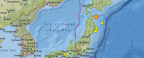
Image credit: USGS
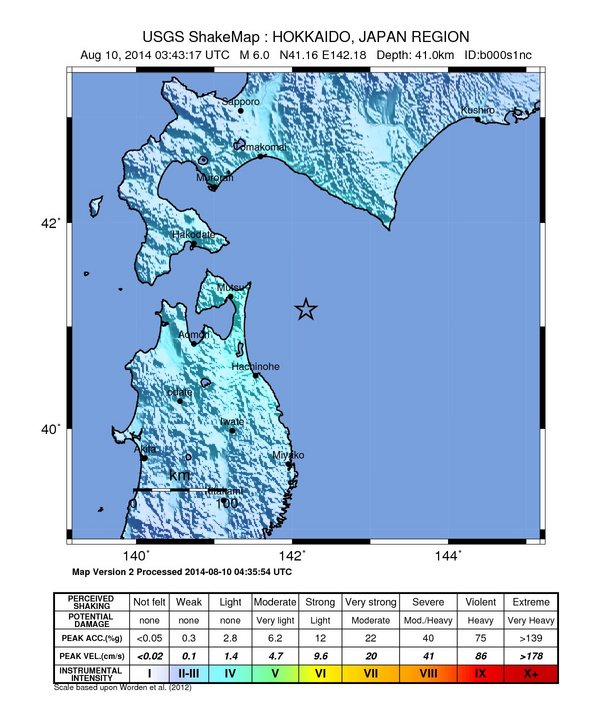
A 6.1-magnitude earthquake (JMA) was registered off the coast of Hokkaido, Japan, at 03:43 UTC on August 10, 2014. JMA is reporting depth of 50 km. USGS is reporting M6.0 at depth of 41 km (25.5 miles).
Epicenter was located 81 km (50 miles) E of Mutsu, 126 km (78 miles) ENE of Aomori-shi and 645 km (401 miles) NNE of Tokyo, Japan.
There are 465 198 people living within 100 km radius.
USGS issued green alert for shaking-related fatalities and economic losses. There is a low likelihood of casualties and damage.
Overall, the population in this region resides in structures that are resistant to earthquake shaking, though some vulnerable structures exist.
Recent earthquakes in this area have caused secondary hazards such as landslides and fires that might have contributed to losses.
Population exposure
Population per ˜1 sq. km. from LandScan
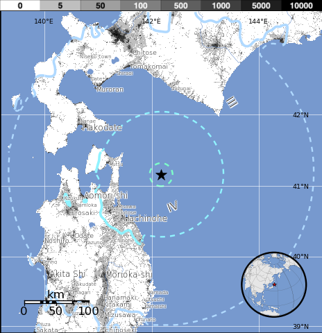
Selected cities exposed
from GeoNames Database of Cities with 1,000 or more residents
| MMI | City | Population |
|---|---|---|
| IV | Mutsu | 49k |
| IV | Uchimaru | <1k |
| IV | Misawa | 43k |
| IV | Hachinohe | 239k |
| IV | Inuotose | <1k |
| IV | Furudate | <1k |
| IV | Aomori-shi | 298k |
| III | Sapporo-shi | 1,883k |
| III | Akita Shi | 326k |
| III | Akita | 320k |
| III | Morioka-shi | 295k |
(k = x1,000)
Seismotectonics of Japan and Vicinity
Japan and the surrounding islands straddle four major tectonic plates: Pacific plate; North America plate; Eurasia plate; and Philippine Sea plate. The Pacific plate is subducted into the mantle, beneath Hokkaido and northern Honshu, along the eastern margin of the Okhotsk microplate, a proposed subdivision of the North America plate. Farther south, the Pacific plate is subducted beneath volcanic islands along the eastern margin of the Philippine Sea plate. This 2,200 km-long zone of subduction of the Pacific plate is responsible for the creation of the deep offshore Ogasawara and Japan trenches as well as parallel chains of islands and volcanoes, typical of Circumpacific island arcs. Similarly, the Philippine Sea plate is itself subducting under the Eurasia plate along a zone, extending from Taiwan to southern Honshu that comprises the Ryukyu Islands and the Nansei-Shoto trench.
Subduction zones at the Japanese island arcs are geologically complex and produce numerous earthquakes from multiple sources. Deformation of the overriding plates generates shallow crustal earthquakes, whereas slip at the interface of the plates generates interplate earthquakes that extend from near the base of the trench to depths of 40 to 60 km. At greater depths, Japanese arc earthquakes occur within the subducting Pacific and Philippine Sea plates and can reach depths of nearly 700 km. Since 1900, three great earthquakes occurred off Japan and three north of Hokkaido. They are the M8.4 1933 Sanriku-oki earthquake, the M8.3 2003 Tokachi-oki earthquake, the M9.0 2011 Tohoku earthquake, the M8.4 1958 Etorofu earthquake, the M8.5 1963 Kuril earthquake, and the M8.3 1994 Shikotan earthquake. (USGS) More information on regional seismicity and tectonics
I'm a dedicated researcher, journalist, and editor at The Watchers. With over 20 years of experience in the media industry, I specialize in hard science news, focusing on extreme weather, seismic and volcanic activity, space weather, and astronomy, including near-Earth objects and planetary defense strategies. You can reach me at teo /at/ watchers.news.
I would guess little risk of tsnami