
Powerful burst of hot ash erupts from Mount Sinabung triggering massive evacuations, Indonesia
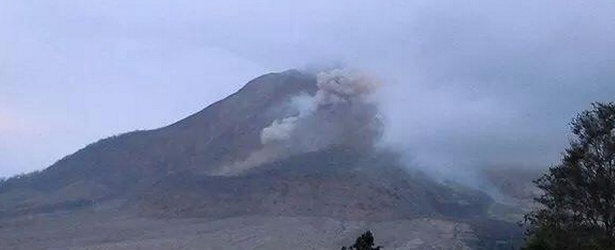
Featured image: Mount Sinabung eruption on June 30, 2014. Image credit: KAROGlobal via Twitter
Powerful burst of hot ash erupted from Mount Sinabung, Karo district of North Sumatra, on June 29, 2014, at 12:29 UTC. The eruption spewed 4 km high column of ash and triggered massive evacuations. Sinabung rumbled back to life in September 2013 after being dormant for 400 years.
The latest eruption occurred only months after the volcano had erupted intermittently from September to February which left 15 people dead and more than 30 000 other internally displaced.
"The hot ash slid into southeast of the crater by up to 4 500 meters," Mr. Sutopo Purwo Nugroho, spokesman of national disaster agency, said.
"Until now, the number of evacuee chalks up to 14 382 people," Sutopo told Xinhua via phone. "The rise of seismic activity has been disseminated among people, hence the condition remains safe," he added. (Xinhua)
The new #pyroclastic flow at #Sinabung #volcano #Indonesia. pic.twitter.com/hhDSHR2ocY
— Roberto Lopez (@Bromotengger) June 29, 2014
Status #Siaga belum dicabut, #Sinabung "batuk" lagi. 30/6/2014. pic.twitter.com/0LpjSdubHK
— #SinabungSiAGA! (@KAROglobal) June 30, 2014
According to GVP, PVMBG reported visual monitoring of Sinabung during June 1 – 17 from the Ndokum Siroga village (~8.5 km of the summit). Dome growth continued and was accompanied by a lava flow that was frequently visibly incandescent.
The observatory noted that the lava flow (particularly avalanches from the flow front) presented a threat to areas S and SE within a 5 km radius from the summit. During this reporting period, seismicity was dominated by tremor associated with avalanches, and there was minor deformation.
Geologic summary
Gunung Sinabung is a Pleistocene-to-Holocene stratovolcano with many lava flows on its flanks. The migration of summit vents along a N-S line gives the summit crater complex an elongated form. The youngest crater of this conical, 2460-m-high andesitic-to-dacitic volcano is at the southern end of the four overlapping summit craters. An unconfirmed eruption was noted in 1881, and solfataric activity was seen at the summit and upper flanks of Sinabung in 1912. No confirmed historical eruptions were recorded prior to explosive eruptions during August-September 2010 that produced ash plumes to 5 km above the summit.
I'm a dedicated researcher, journalist, and editor at The Watchers. With over 20 years of experience in the media industry, I specialize in hard science news, focusing on extreme weather, seismic and volcanic activity, space weather, and astronomy, including near-Earth objects and planetary defense strategies. You can reach me at teo /at/ watchers.news.
Commenting rules and guidelines
We value the thoughts and opinions of our readers and welcome healthy discussions on our website. In order to maintain a respectful and positive community, we ask that all commenters follow these rules.