
GOES animation of the U.S. tornadoes from April 27 – 28, 2014
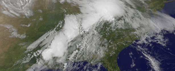
Image credit: TW
NASA released an animation of visible and infrared satellite data from NOAA's GOES-East satellite that shows the development and movement of the weather system that spawned tornadoes affecting seven central and southern U.S. states on April 27 – 28, 2014. NASA's Aqua satellite captured infrared data on the system that revealed powerful storms, high into the troposphere.
This storm system generated reports of tornadoes from Nebraska, Kansas, Iowa, Oklahoma, Arkansas, Louisiana, and Mississippi.
The NOAA / NWS Storm Prediction Center is forecasting a widespread severe weather outbreak Monday afternoon into Monday night across portions of the southern and eastern U.S. (local time). The greatest potential – where SPC has outlined a Moderate Risk – is across the lower Mississippi and Tennessee Valleys. Widespread severe storms – including strong tornadoes, damaging winds and very large hail are expected.
For updated information about the storm system, visit NOAA's NWS website: www.weather.gov
Featured image and video credit: NASA/NOAA GOES Project
I'm a dedicated researcher, journalist, and editor at The Watchers. With over 20 years of experience in the media industry, I specialize in hard science news, focusing on extreme weather, seismic and volcanic activity, space weather, and astronomy, including near-Earth objects and planetary defense strategies. You can reach me at teo /at/ watchers.news.
Commenting rules and guidelines
We value the thoughts and opinions of our readers and welcome healthy discussions on our website. In order to maintain a respectful and positive community, we ask that all commenters follow these rules.