
Blizzard conditions hit Midwest as powerful winter storm threatens East Coast, U.S.
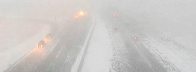
Image credit: Sean Macaday
A powerful winter storm brought blizzard conditions to the U.S. Midwest on Wednesday, December 23, 2020, and is set to threaten much of the East Coast on Christmas Eve and Christmas Day, December 24 and 25. Heavy rains and the existing melting snow from last week's storm pose a flooding risk to mid-Atlantic and New England, while severe thunderstorms and tornadoes are possible in the eastern Carolinas and southeast Virginia, according to the National Weather Service (NWS).
Blizzard warnings were in force across much of the Upper Midwest on Wednesday night, with winds over 105 km/h (65 mph) reported in parts of the Dakotas, impacting holiday travelers as road conditions were rough in some areas.
Winter storm warnings were also in place for Minnesota's Twin Cities, with near white-out conditions expected.
Hundreds of car crashes were reported, as well as stalled and spun-out vehicles, from Wednesday afternoon to evening, according to Sargeant Jesse Grabow, spokesman for Northwestern, West Central, and Central Minnesota State Patrol.
With most of the state of Minnesota under a Blizzard Warning, the weather quickly turned from blustery to freezing rain sleet and then to heavy snow with whiteout conditions in less than an hour on December 23.
The video below shows what was being called a several dozen multi-vehicle pileup on Interstate 94 near Albertville, MN. Interstate 94 was shut down in both directions in this area for much of the afternoon and evening as crews worked late into the evening to try and clear the scene.
"Troopers and other law enforcement along with first responders continue to respond to stuck & stranded motorists throughout parts of MN into the night. Please take note of any no travel advisories and stay safe," said Grabow.
Minnesota governor Tim Walz has given authority to the state's National Guard to provide emergency assistance for drivers who were stranded in the winter storm.
Troopers and other law enforcement along with first responders continue to respond to stuck & stranded motorists throughout parts of MN into the night. Please take note of any no travel advisories and stay safe. #MNwx https://t.co/UtVIO32TcR pic.twitter.com/mKDbk0AH9V
— Sgt. Jesse Grabow (@MSPPIO_NW) December 24, 2020
Blizzard up in Fargo today.
Again, if you’re trying to drive through this in the upper Midwest today, don’t. pic.twitter.com/ktw4CNTyxu
— Sean Macaday (@MacadayWX) December 23, 2020
Just a little Midwest blow storm #Blizzard pic.twitter.com/r1vFSM4KfI
— Just Josh (@Jmann500) December 24, 2020
Watch the drifts move down the lake as the wind and snow take over. At the very end, we have whiteout conditions in Albert Lea. Timelapses rock. #AlbertLea #MNWX #Blizzard #WhiteOut pic.twitter.com/klDOCk69Ic
— Chris Kuball (@ChrisKuball) December 24, 2020
"…on second thought, maybe I don't want to go outside." It's a good night to stay in while the #blizzard howls across the Upper Midwest tonight. #MNwx
Video: @erinvaltinson pic.twitter.com/pUzvbXEqLe— WeatherNation (@WeatherNation) December 24, 2020
The NWS warned that the storm system will continue to impact the eastern third of the U.S. into Christmas day. The low-pressure system is forecast to track northeastward into southeast Canada as another low along its cold front takes over and heads northward across the eastern U.S.
"Rain will change to snow west of the Appalachians and in the Great Lakes while locally heavy rainfall and snowmelt may result in flooding in the Mid Atlantic and Northeast along with the risk of strong winds," it stated.
"Severe thunderstorms and tornadoes are possible in the eastern Carolinas and southeast Virginia."
Slight risks of excessive rainfall are set to take effect from the Appalachians to the Northeast along with moderate risk in parts of Pennsylvania and New York on Christmas Eve. The risk is set to push through Christmas Day.
NWS added that in some areas rain will fall on a relatively fresh snowpack from the nor'easter in the previous week.
Non-thunderstorm wind gusts are also a threat. High Wind Warnings and Wind Advisories are in effect for much of the Northeast.
Commenting rules and guidelines
We value the thoughts and opinions of our readers and welcome healthy discussions on our website. In order to maintain a respectful and positive community, we ask that all commenters follow these rules.