
Massive earthquake M7.5 reported off the coast of Bougainville Island
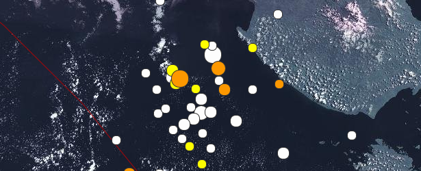
Image credit: USGS
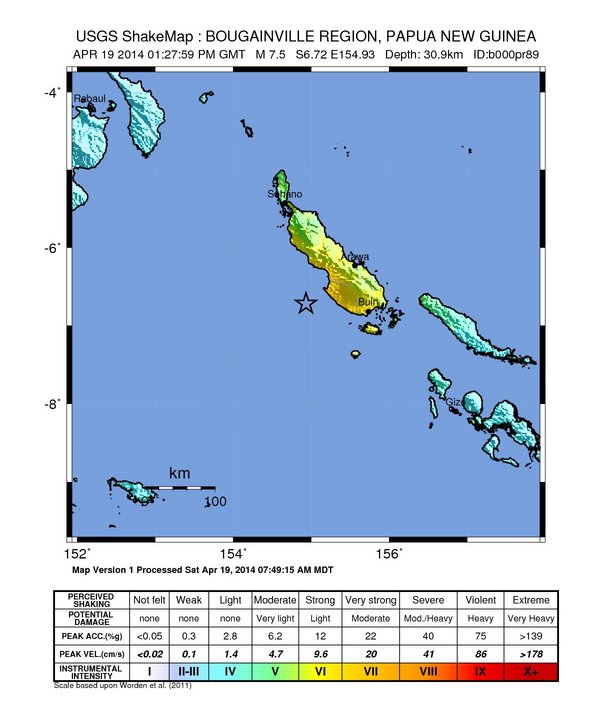
A massive earthquake measuring M7.5 was recorded off the coast of Bougainville Island, Autonomous Region of Bougainville, on April 19, 2014 at 13:27 UTC.
USGS said this event is the latest in an ongoing sequence of seismicity in the same region over the past week, which began with M 7.1 and 6.5 earthquakes on April 11, respectively just to the northeast and southeast of today's earthquake. Over the intervening eight days, 45 earthquakes of M 4.5 or greater have occurred nearby. See the complete list below.
They reported depth of 30.9 km (19.2 miles) and issued Green alert for shaking-related fatalities and economic losses – there is a low likelihood of casualties and damage. EMSC is also reporting M7.5 at the same depth.
GDACS estimated there are 89 479 people living within 100 km radius.
According to JRC's global tsunami wave height calculation model, which is run after each earthquake issued by seismological institutes around the world, the maximum tsunami wave height is 0.7 m in Koiaris, Papua New Guinea. This height is estimated for April 19, 2014 at 14:25 UTC.
USGS explains: "This earthquake occurred as the result of thrust faulting on or near the subduction zone interface between the subducting Australia plate and overriding Pacific plate. At the location of the earthquake, the Australia plate moves towards the east-northeast at a velocity of 102 mm/yr with respect to the Pacific, and begins its subduction into the mantle beneath Bougainville Island at the New Britain Trench south of the earthquake.
The moment tensor and depth of the event are consistent with thrust-type motion on the interface between these two plates. Note that at the location of the earthquake, some researchers divide the edge of the Australia plate into several microplates that take up the overall convergence between Australia and the Pacific. Here the Solomon Sea plate moves slightly faster and more northeasterly with respect to the Pacific plate than does Australia due to sea-floor spreading in the Woodlark Basin several hundred kilometers to the south of the April 19 earthquake.
In the Papua New Guinea region, the boundary between Australia and Pacific plates is very active seismically; 35 M 7+ events have occurred within 250 km of the April 19, 2014 earthquake over the past century. None are known to have caused any shaking-related fatalities. The largest was an M 8.0 175 km to the northwest of the April 19, 2014 earthquake, one of two M8+ earthquakes 140 km apart in July 1971. The M 8.1 Solomon Islands earthquake in April 2007, which caused a devastating tsunami, was 300 km southeast of the April 19, 2014 event."
Seismotectonics of the New Guinea Region and Vicinity
The Australia-Pacific plate boundary is over 4000 km long on the northern margin, from the Sunda (Java) trench in the west to the Solomon Islands in the east. The eastern section is over 2300 km long, extending west from northeast of the Australian continent and the Coral Sea until it intersects the east coast of Papua New Guinea. The boundary is dominated by the general northward subduction of the Australia plate.
Along the South Solomon trench, the Australia plate converges with the Pacific plate at a rate of approximately 95 mm/yr towards the east-northeast. Seismicity along the trench is dominantly related to subduction tectonics and large earthquakes are common: there have been 13 M7.5+ earthquakes recorded since 1900. On April 1, 2007, a M8.1 interplate megathrust earthquake occurred at the western end of the trench, generating a tsunami and killing at least 40 people. This was the third M8.1 megathrust event associated with this subduction zone in the past century; the other two occurred in 1939 and 1977.
Further east at the New Britain trench, the relative motions of several microplates surrounding the Australia-Pacific boundary, including north-south oriented seafloor spreading in the Woodlark Basin south of the Solomon Islands, maintain the general northward subduction of Australia-affiliated lithosphere beneath Pacific-affiliated lithosphere. Most of the large and great earthquakes east of New Guinea are related to this subduction; such earthquakes are particularly concentrated at the cusp of the trench south of New Ireland. 33 M7.5+ earthquakes have been recorded since 1900, including three shallow thrust fault M8.1 events in 1906, 1919, and 2007.
The western end of the Australia-Pacific plate boundary is perhaps the most complex portion of this boundary, extending 2000 km from Indonesia and the Banda Sea to eastern New Guinea. The boundary is dominantly convergent along an arc-continent collision segment spanning the width of New Guinea, but the regions near the edges of the impinging Australia continental margin also include relatively short segments of extensional, strike-slip and convergent deformation. The dominant convergence is accommodated by shortening and uplift across a 250-350 km-wide band of northern New Guinea, as well as by slow southward-verging subduction of the Pacific plate north of New Guinea at the New Guinea trench. Here, the Australia-Pacific plate relative velocity is approximately 110 mm/yr towards the northeast, leading to the 2-8 mm/yr uplift of the New Guinea Highlands.
Whereas the northern band of deformation is relatively diffuse east of the Indonesia-Papua New Guinea border, in western New Guinea there are at least two small (<100,000 km²) blocks of relatively undeformed lithosphere. The westernmost of these is the Birds Head Peninsula microplate in Indonesia's West Papua province, bounded on the south by the Seram trench. The Seram trench was originally interpreted as an extreme bend in the Sunda subduction zone, but is now thought to represent a southward-verging subduction zone between Birds Head and the Banda Sea.
There have been 22 M7.5+ earthquakes recorded in the New Guinea region since 1900. The dominant earthquake mechanisms are thrust and strike slip, associated with the arc-continent collision and the relative motions between numerous local microplates. The largest earthquake in the region was a M8.2 shallow thrust fault event in the northern Papua province of Indonesia that killed 166 people in 1996.
The western portion of the northern Australia plate boundary extends approximately 4800 km from New Guinea to Sumatra and primarily separates Australia from the Eurasia plate, including the Sunda block. This portion is dominantly convergent and includes subduction at the Sunda (Java) trench, and a young arc-continent collision.
In the east, this boundary extends from the Kai Islands to Sumba along the Timor trough, offset from the Sunda trench by 250 km south of Sumba. Contrary to earlier tectonic models in which this trough was interpreted as a subduction feature continuous with the Sunda subduction zone, it is now thought to represent a subsiding deformational feature related to the collision of the Australia plate continental margin and the volcanic arc of the Eurasia plate, initiating in the last 5-8 Myr. Before collision began, the Sunda subduction zone extended eastward to at least the Kai Islands, evidenced by the presence of a northward-dipping zone of seismicity beneath Timor Leste. A more detailed examination of the seismic zone along it's eastern segment reveals a gap in intermediate depth seismicity under Timor and seismic mechanisms that indicate an eastward propagating tear in the descending slab as the negatively buoyant oceanic lithosphere detaches from positively buoyant continental lithosphere. On the surface, GPS measurements indicate that the region around Timor is currently no longer connected to the Eurasia plate, but instead is moving at nearly the same velocity as the Australia plate, another consequence of collision.
Large earthquakes in eastern Indonesia occur frequently but interplate megathrust events related to subduction are rare; this is likely due to the disconnection of the descending oceanic slab from the continental margin. There have been 9 M7.5+ earthquakes recorded from the Kai Islands to Sumba since 1900. The largest was the great Banda Sea earthquake of 1938 (M8.5) an intermediate depth thrust faulting event that did not cause significant loss of life. (USGS) More information on regional seismicity and tectonics
The following list contains all earthquakes reported near the Bougainville Island since March 23, 2014:
- 5.62014-04-19 13:47:51 UTC72.2 km
- 7.52014-04-19 13:27:59 UTC30.9 km
- 5.22014-04-19 13:21:20 UTC62.4 km
- 6.62014-04-19 01:04:03 UTC24.4 km
- 4.72014-04-18 17:53:44 UTC84.4 km
- 4.52014-04-17 21:09:08 UTC104.6 km
- 4.82014-04-16 22:43:27 UTC80.1 km
- 5.42014-04-16 20:00:06 UTC38.9 km
- 4.72014-04-14 19:45:55 UTC55.0 km
- 4.72014-04-13 21:49:04 UTC39.8 km
- 5.32014-04-13 13:19:19 UTC35.0 km
- 4.72014-04-13 09:12:07 UTC86.4 km
- 4.62014-04-13 06:13:20 UTC68.1 km
- 5.32014-04-12 15:59:27 UTC6.7 km
- 5.02014-04-12 15:46:28 UTC22.6 km
- 4.62014-04-12 11:42:34 UTC43.4 km
- 4.92014-04-12 10:55:46 UTC47.2 km
- 4.62014-04-12 08:54:11 UTC57.8 km
- 4.72014-04-12 06:22:21 UTC89.9 km
- 5.32014-04-12 06:15:36 UTC41.0 km
- 5.12014-04-12 05:29:37 UTC35.0 km
- 6.12014-04-12 05:24:25 UTC35.0 km
- 4.52014-04-12 05:03:31 UTC58.9 km
- 4.32014-04-12 04:38:32 UTC75.1 km
- 5.12014-04-12 04:00:56 UTC50.2 km
- 4.42014-04-12 01:33:12 UTC125.9 km
- 4.72014-04-11 22:02:34 UTC71.8 km
- 4.82014-04-11 19:06:11 UTC11.1 km
- 4.92014-04-11 18:56:14 UTC12.8 km
- 4.82014-04-11 18:52:25 UTC15.8 km
- 4.72014-04-11 18:20:58 UTC91.6 km
- 4.72014-04-11 16:43:04 UTC63.1 km
- 4.92014-04-11 16:35:32 UTC81.8 km
- 4.92014-04-11 15:52:44 UTC47.2 km
- 5.62014-04-11 14:33:43 UTC21.3 km
- 5.52014-04-11 12:55:22 UTC44.8 km
- 4.62014-04-11 12:34:04 UTC50.6 km
- 4.72014-04-11 10:47:21 UTC79.7 km
- 5.12014-04-11 10:30:31 UTC35.0 km
- 4.72014-04-11 09:35:57 UTC65.7 km
- 4.82014-04-11 08:39:04 UTC44.3 km
- 5.22014-04-11 08:31:48 UTC52.6 km
- 5.12014-04-11 08:23:46 UTC45.9 km
- 6.52014-04-11 08:16:48 UTC39.4 km
- 7.12014-04-11 07:07:21 UTC50.0 km
- 4.82014-04-07 14:30:01 UTC82.6 km
- 4.82014-03-29 04:26:52 UTC113.5 km
- 5.12014-03-25 19:56:14 UTC179.8 km
- 4.22014-03-23 02:20:56 UTC131.9 km
I'm a dedicated researcher, journalist, and editor at The Watchers. With over 20 years of experience in the media industry, I specialize in hard science news, focusing on extreme weather, seismic and volcanic activity, space weather, and astronomy, including near-Earth objects and planetary defense strategies. You can reach me at teo /at/ watchers.news.
and it burns burns burns…the ring of fire…the ring of fire
https://www.youtube.com/watch?v=It7107ELQvY&feature=kp
F!g Tree reborn = Th!s Generat!on