
Yellowstone trembles again – new earthquake swarm underway
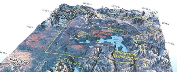
Image credit: USGS - YVO
A new earthquake swarm is currently underway at Yellowstone National Park, USA. According to the earthquake list of University of Utah, a new series of relatively stronger earthquakes started on November 23, 2013. Almost all of them are located approximately 19 km (12 miles) NNE of West Yellowstone, MT.
Most noticeable earthquakes are M 3.3 that struck on November 23 at 20:47 UTC (13:47 local time) and M 3.1 that struck on November 24 at 07:18 UTC (00:18 local time).
Keep in mind that we are still 7 days before the new YVO monthly update report when more data will be available.
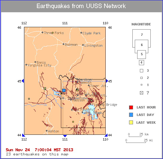
Image credit: UUSS
Below is the list pf earthquakes recorded by University of Utah Seismograph Stations for the last week (November 24, 2013, at 14:00 UTC – past 168 hours). Times are local (MST or MDT), for UTC time add 7 hours. Most recent earthquakes are at the top of the list. Click on the word "map" or "MAP" to see a map view. Click on a "DATE" to get additional text information. Magnitude 3 and greater earthquakes are printed in bold type.
- MAP 3.1 2013/11/24 00:18:35 44.820N 111.022W 11.5 19 km (12 mi) NNE of West Yellowstone, MT
- map 2.9 2013/11/23 16:03:06 44.823N 111.024W 11.7 19 km (12 mi) NNE of West Yellowstone, MT
- map 2.2 2013/11/23 15:25:44 44.819N 111.022W 11.2 19 km (12 mi) NNE of West Yellowstone, MT
- MAP 3.3 2013/11/23 13:47:35 44.822N 111.025W 11.9 19 km (12 mi) NNE of West Yellowstone, MT
- map 2.6 2013/11/23 13:38:12 44.815N 111.021W 11.9 18 km (11 mi) NNE of West Yellowstone, MT
- map 2.8 2013/11/23 13:23:48 44.814N 111.018W 11.4 18 km (11 mi) NNE of West Yellowstone, MT
- map 2.7 2013/11/23 07:15:09 45.691N 112.006W 10.6 17 km (11 mi) W of Harrison, MT
- map 0.9 2013/11/22 04:08:08 44.529N 112.813W 4.7 21 km (13 mi) SW of Lima, MT
- map 1.5 2013/11/21 23:08:54 38.151N 112.527W 1.9 17 km (11 mi) SE of Beaver, UT
- map 1.2 2013/11/21 09:49:50 38.964N 111.384W 3.1 13 km ( 8 mi) WNW of Emery, UT
- map 1.4 2013/11/21 08:31:43 44.764N 111.094W 14.2 11 km ( 7 mi) N of West Yellowstone, MT
- map 0.8 2013/11/21 01:21:44 39.681N 111.544W -0.8 10 km ( 6 mi) NE of Fountain Green, UT
- map 0.6 2013/11/21 01:04:22 44.766N 111.084W 10.6 12 km ( 7 mi) N of West Yellowstone, MT
- map 1.2 2013/11/20 23:15:12 44.839N 111.493W 5.7 36 km (23 mi) WNW of West Yellowstone, MT
- map 1.2 2013/11/20 20:30:30 44.629N 110.343W 7.5 54 km (33 mi) SW of Cooke City-Silver Gate, MT
- map 1.2 2013/11/20 16:03:48 38.515N 111.908W 7.5 2 km ( 1 mi) WNW of Koosharem, UT
- map 1.8 2013/11/20 13:22:58 45.894N 111.293W 2.7 5 km ( 3 mi) NE of Manhattan, MT
- map 1.8 2013/11/20 13:17:03 36.940N 113.629W 2.9 18 km (11 mi) SSW of St. George, UT
- map 2.1 2013/11/20 11:36:43 42.926N 111.142W 1.1 12 km ( 7 mi) W of Thayne, WY
- map 1.7 2013/11/20 11:00:00 39.002N 111.344W 1.7 12 km ( 7 mi) NW of Emery, UT
- map 1.6 2013/11/20 10:59:59 39.001N 111.341W -0.4 12 km ( 7 mi) NW of Emery, UT
- map 2.6 2013/11/19 19:32:33 44.856N 111.487W 4.6 37 km (23 mi) NW of West Yellowstone, MT
- map 0.7 2013/11/19 19:02:01 44.832N 110.702W 3.7 23 km (14 mi) S of Gardiner, MT
- map 0.6 2013/11/19 17:31:18 44.753N 111.005W 9.9 13 km ( 8 mi) NE of West Yellowstone, MT
- map 2.2 2013/11/19 17:27:58 44.827N 110.698W 4.8 23 km (14 mi) S of Gardiner, MT
- map 1.5 2013/11/19 17:27:49 44.762N 111.089W 10.2 11 km ( 7 mi) N of West Yellowstone, MT
- map 2.2 2013/11/19 17:27:00 44.835N 110.689W 6.2 22 km (14 mi) S of Gardiner, MT
- map 0.9 2013/11/19 16:32:41 44.765N 111.085W 10.2 12 km ( 7 mi) N of West Yellowstone, MT
- map 1.3 2013/11/19 15:18:38 44.766N 111.081W 10.7 12 km ( 7 mi) N of West Yellowstone, MT
- map 1.5 2013/11/19 09:12:07 44.762N 111.090W 10.6 11 km ( 7 mi) N of West Yellowstone, MT
- map 1.0 2013/11/19 02:25:56 38.962N 111.405W 3.6 14 km ( 9 mi) WNW of Emery, UT
- map 1.1 2013/11/19 01:58:56 45.307N 112.600W 11.5 11 km ( 7 mi) NNE of Dillon, MT
- map 2.2 2013/11/19 00:48:49 44.573N 114.291W 12.4 9 km ( 6 mi) NNW of Challis, ID
- map 1.2 2013/11/18 21:55:32 38.959N 111.386W 8.6 13 km ( 8 mi) WNW of Emery, UT
- map 1.4 2013/11/18 21:48:54 38.957N 111.402W 2.5 14 km ( 9 mi) WNW of Emery, UT
- map 1.0 2013/11/18 16:24:35 44.662N 111.876W 13.0 41 km (26 mi) NE of Spencer, ID
- map 2.0 2013/11/18 13:35:07 38.962N 111.418W 2.8 15 km ( 9 mi) WNW of Emery, UT
- map 1.7 2013/11/18 01:41:48 39.313N 111.962W 10.2 14 km ( 8 mi) NW of Fayette, UT
- map 0.9 2013/11/17 19:41:25 39.301N 111.953W 12.7 12 km ( 7 mi) NW of Fayette, UT
- map 1.6 2013/11/17 15:34:42 44.238N 110.793W 4.9 44 km (27 mi) ENE of Warm River, ID
- map 1.1 2013/11/17 07:56:20 39.305N 111.932W 13.6 11 km ( 7 mi) NW of Fayette, UT
I'm a dedicated researcher, journalist, and editor at The Watchers. With over 20 years of experience in the media industry, I specialize in hard science news, focusing on extreme weather, seismic and volcanic activity, space weather, and astronomy, including near-Earth objects and planetary defense strategies. You can reach me at teo /at/ watchers.news.
Six years gives me enough time to think!
Why in the world are you posting stuff that’s 6 years old?!?!
Check date of publishing.. your comment comes 6 years after the article was posted.
It was written in 2013. Why are they posting it as new now! Hurts their credibility a lot.
Who is posting this?
thats what Im talkin bout…
https://www.youtube.com/watch?v=_-eVgV4PzX8