
Massive and shallow M 7.8 earthquake struck near South Orkney Island, Scotia Sea
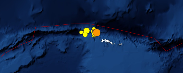
Image credit: USGS
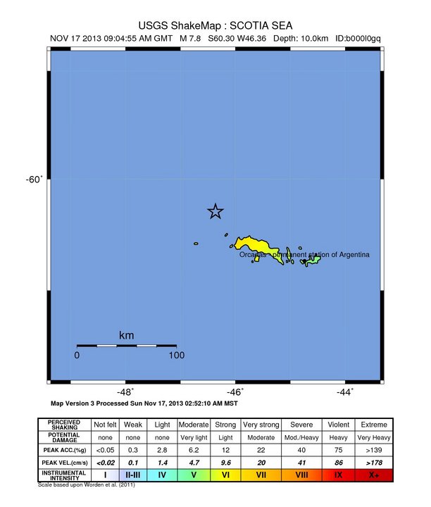
After series of foreshocks that struck near South Orkney Islands in last 4 days, a massive and shallow M 7.8 earthquake struck the same area on November 17, 2013 at 09:04 UTC. USGS measured depth at 10 km (6.8 miles), EMSC is reporting M 7.6 at 30 km.
There is no permanent human population nearby. The primary presence on the Orkney Islands is related to two research stations run by Argentina and Great Britain.
There were no tsunami warnings issued. However, earthquakes of this size are known to generate tsunamis dangerous to shorelines near the source. Orkney Islands are located in South Pacific Ocean, approximately 640 km (400 miles) north east of the northern tip of the Antarctic Peninsula.
Tectonic summary
The November 17, 2013 earthquake in the Scotia Sea, to the northwest of the South Orkney Islands, occurred as the result of either left-lateral strike slip faulting on an east-west oriented plane, or right-lateral faulting on a north-south plane. The location of the event adjacent to the east-west oriented plate boundary between the Antarctica and Scotia Sea plates implies the left-lateral faulting scenario is most likely. At the latitude of this earthquake, the Antarctica plate moves eastwards with respect to the Scotia Sea plate at a velocity of 6 mm/yr.
Though the region surrounding the Scotia Sea is familiar with earthquakes, the majority occur around the subduction zone adjacent to the South Sandwich Islands, to the east of the November 17 earthquake. Just two events of M6 or greater have occurred within 250 km of this earthquake over the past 40 years – a M 6.0 230 km to the west in September 1979, and a M 7.6 160 km to the east in August 2003. These two events involved normal and oblique-normal faulting, respectively, associated with the same plate boundary. Neither is known to have caused damage or fatalities. (USGS)
Below is the updated list and map of earthquake sequence that started with M 6.1 at 23:45 UTC on November 13, 2013.
[Time of update: November 17, 2013 at 17:30 UTC. Total of 31 earthquakes.]
- M 5.0 – 2013-11-17 @ 14:59:13 UTC – Depth: 15.6 km
- M 4.9 – 2013-11-17 @ 14:24:50 UTC – Depth: 16.6 km
- M 5.0 – 2013-11-17 @ 14:24:08 UTC – Depth: 14.5 km
- M 4.9 – 2013-11-17 @ 14:04:18 UTC – Depth: 14.7 km
- M 5.0 – 2013-11-17 @ 13:42:44 UTC – Depth: 14.6 km
- M 4.7 – 2013-11-17 @ 13:11:12 UTC – Depth: 14.5 km
- M 5.3 – 2013-11-17 @ 12:45:25 UTC – Depth: 10.0 km
- M 5.7 – 2013-11-17 @ 12:11:36 UTC – Depth: 10.0 km
- M 4.7 – 2013-11-17 @ 11:41:48 UTC – Depth: 10.0 km
- M 5.0 – 2013-11-17 @ 11:38:33 UTC – Depth: 10.0 km
- M 4.6 – 2013-11-17 @ 11:34:16 UTC – Depth: 10.0 km
- M 5.2 – 2013-11-17 @ 11:13:02 UTC – Depth: 10.0 km
- M 5.0 – 2013-11-17 @ 11:12:12 UTC – Depth: 10.0 km
- M 4.8 – 2013-11-17 @ 10:59:07 UTC – Depth: 10.0 km
- M 4.9 – 2013-11-17 @ 10:48:51 UTC – Depth: 10.0 km
- M 5.3 – 2013-11-17 @ 10:44:07 UTC – Depth: 10.0 km
- M 4.7 – 2013-11-17 @ 09:57:08 UTC – Depth: 10.0 km
- M 7.8 – 2013-11-17 @ 09:04:55 UTC – Depth: 10.0 km
- M 4.9 – 2013-11-16 @ 19:39:16 UTC – Depth: 10.0 km
- M 4.7 – 2013-11-16 @ 15:04:22 UTC – Depth: 10.0 km
- M 5.1 – 2013-11-16 @ 15:00:12 UTC – Depth: 10.0 km
- M 4.7 – 2013-11-16 @ 09:51:25 UTC – Depth: 10.0 km
- M 5.2 – 2013-11-16 @ 09:35:46 UTC – Depth: 10.0 km
- M 5.4 – 2013-11-16 @ 08:35:06 UTC – Depth: 10.0 km
- M 5.1 – 2013-11-16 @ 08:18:11 UTC – Depth: 10.0 km
- M 5.3 – 2013-11-16 @ 04:45:33 UTC – Depth: 10.0 km
- M 4.8 – 2013-11-16 @ 04:16:04 UTC – Depth: 10.2 km
- M 4.9 – 2013-11-16 @ 04:01:18 UTC – Depth: 10.3 km
- M 6.8 – 2013-11-16 @ 03:34:31 UTC – Depth: 10.0 km
- M 4.4 – 2013-11-15 @ 08:10:17 UTC – Depth: 10.0 km
- M 6.1 – 2013-11-13 @ 23:45:48 UTC – Depth: 10.0 km – Start of earthquake sequence
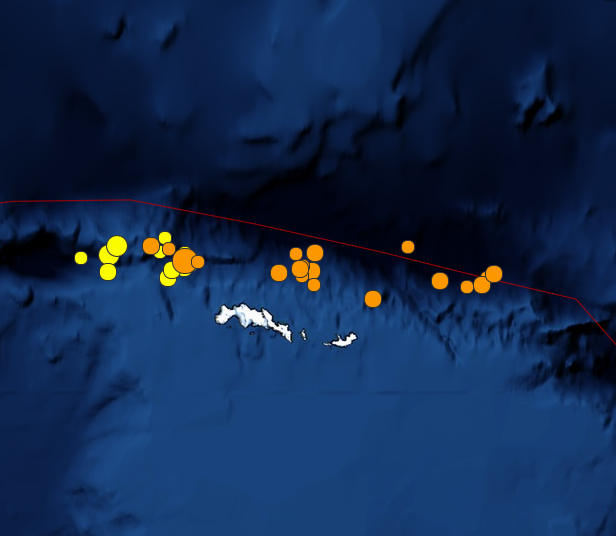
Map of earthquakes associated with the list above. After M 7.8 earthquakes shifted east along the South Scotia Ridge. Image credit: USGS
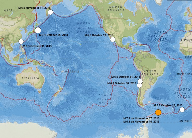
Map below shows significant worldwide earthquakes in last 30 days. Map and data source: USGS
Map and data source: USGS
I'm a dedicated researcher, journalist, and editor at The Watchers. With over 20 years of experience in the media industry, I specialize in hard science news, focusing on extreme weather, seismic and volcanic activity, space weather, and astronomy, including near-Earth objects and planetary defense strategies. You can reach me at teo /at/ watchers.news.
Commenting rules and guidelines
We value the thoughts and opinions of our readers and welcome healthy discussions on our website. In order to maintain a respectful and positive community, we ask that all commenters follow these rules.