
Tropical Storm Kong-Rey battling wind shear – passing east of Taiwan toward Japan
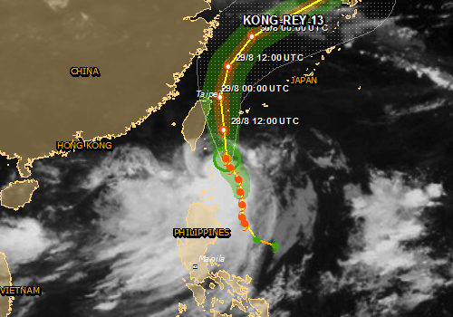
Image credit: JRC
Satellite imagery on August 27, 2013, showed that wind shear was having an effect on the thunderstorms in Tropical Storm Kong-Rey's northern quadrant.
NASA's Aqua satellite passed over TS Kong-Rey on August 27 at 05:15 UTC and the Moderate Resolution Imaging Spectroradiometer took a visible image of the storm. The imagery showed that the northern quadrant of the storm had the weakest area of thunderstorm development as a result of northeasterly wind shear, while the southern and western quadrants had strong thunderstorms. Wind shear is expected to relax somewhat, allowing Kong-Rey to intensify over the next day before it begins weakening.
At 15:00 UTC August 27, Kong-Rey's maximum sustained winds were near 50 knots/57 mph/92.6 km/h and the Joint Typhoon Warning Center is predicting a slow intensification. Kong-Rey was centered near 20.5 north and 123.6 east, about 324 nautical miles south-southeast of Taipei, Taiwan and is moving to the north at 8 knots/9.2 mph/14.8 km/h.
It is expected to pass east of Taiwan and then a mid-latitude trough (elongated area of low pressure) moving in from the northwest is expected to push the storm in a northeasterly direction and weaken it in the next couple of days.
Kong-Rey is 14th tropical cyclone generated in the northwestern Pacific. It formed from low pressure System 91W on August 25th.
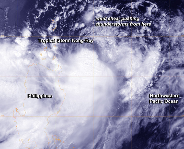
NASA's Aqua satellite passed over Kong-Rey on August 27 at 05:15 UTC and saw the northern quadrant had the weakest area of thunderstorm development as a result of northeasterly wind shear, while the southern and western quadrants had strong thunderstorms. Image credit: NRL/NASA
![]()
Tropical Storm Kong-Rey tracking map / warning graphic. Source: JTWC
TS Kong-Rey is forecast to strike Japan at about 02:00 UTC on August 31. Data supplied by the US Navy and Air Force Joint Typhoon Warning Center suggest that the point of landfall will be near 31.2 N, 130.1 E. Kong-rey is expected to bring 1-minute maximum sustained winds to the region of around 83 km/h (51 mph). Wind gusts in the area may be considerably higher.
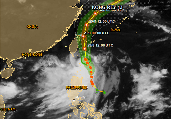
Tropical Storm Kong-Rey – cloud map. The map shows the areas affected by tropical storm strength winds (green), 58mph winds (orange) and cyclone wind strengths (red). (Source: JRC)
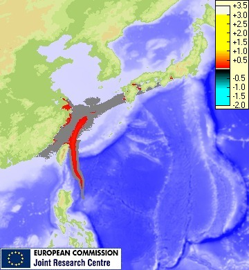
Storm surge maximum height. Source and credit: JRC
Up to 49.2 million people people can be affected by wind speeds of tropical storm strength or above. In addition, 7.7 million people people are living in coastal areas below 5 m and can therefore be affected by storm surge.
I'm a dedicated researcher, journalist, and editor at The Watchers. With over 20 years of experience in the media industry, I specialize in hard science news, focusing on extreme weather, seismic and volcanic activity, space weather, and astronomy, including near-Earth objects and planetary defense strategies. You can reach me at teo /at/ watchers.news.
Commenting rules and guidelines
We value the thoughts and opinions of our readers and welcome healthy discussions on our website. In order to maintain a respectful and positive community, we ask that all commenters follow these rules.