
Active volcanoes in the world: October 24 – October 30, 2012
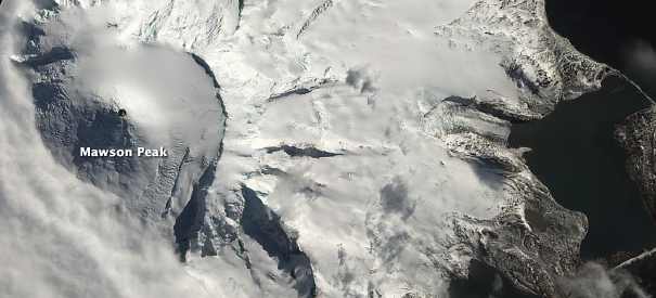
Image credit: Clad in pristine snow and glacial ice, Mawson Peak appears quiet. However, reports by Volcano Live and heat signatures detected by a satellite suggest recent activity at the volcano.Although not definitive, this natural-color satellite image also suggests an ongoing eruption. The dark summit crater—much darker than Mawson’s shaded southwestern face—is at least partially snow-free. There is also a faint hint of an even darker area—perhaps a lava flow—within. Shortwave infrared data shows hot surfaces within the crater, indicating the presence of lava in or just beneath the crater. Heavy cloud cover camouflaged what may have been a plume that erupted less than an hour after the image above was captured.Because the volcano is located on the inaccessible Heard Island, 2,000 kilometers (1,200 miles) north of Antarctica and 2,700 kilometers (1,700 miles) southeast of Africa, satellites are the primary means of monitoring Mawson Peak. This image was acquired on October 13, 2012 by the Advanced Land Imager (ALI) aboard the Earth Observing-1 (EO-1) satellite.NASA Earth Observatory image by Robert Simmon, using EO-1 ALI data from the NASA EO-1 team and USGS Global Visualization Viewer. Caption by Robert Simmon.
New unrest has been noticed around 2 volcanoes, ongoing activity was reported for 8 volcanoes. This report covers active volcanoes in the world recorded from October 24 – October 30, 2012 based on Smithsonian/USGS criteria.
The Weekly Volcanic Activity Report is a cooperative project between the Smithsonian’s Global Volcanism Program and the US Geological Survey’s Volcano Hazards Program. Updated by 23:00 UTC every Wednesday, notices of volcanic activity posted on these pages are preliminary and subject to change as events are studied in more detail. This is not a comprehensive list of all of Earth’s volcanoes erupting during the week, but rather a summary of activity at volcanoes that meet criteria discussed in detail in the “Criteria and Disclaimers” section. Carefully reviewed, detailed reports on various volcanoes are published monthly in the Bulletin of the Global Volcanism Network.
New activity/unrest: | Heard, Southern Indian Ocean | Poás, Costa Rica
Ongoing activity: | Galeras, Colombia | Iliamna, Southwestern Alaska | Karymsky, Eastern Kamchatka (Russia) | Kilauea, Hawaii (USA) | Popocatépetl, México | Sakura-jima, Kyushu | Santa María, Guatemala | Shiveluch, Central Kamchatka (Russia)
New activity/unrest
HEARD, Southern Indian Ocean
53.106°S, 73.513°E; summit elev. 2745 m
According to Volcano Live, satellite imagery of Heard Island showed thermal anomalies on 21 and 24 September, and 10 and 19 October. NASA’s Earth Observatory reported that a satellite image acquired on 13 October showed a possible dark area in the summit crater of Mawson Peak and hot surfaces within the crater, indicating the presence of lava in or just beneath the crater.
Geologic summary: Heard Island on the Kerguelen Plateau in the southern Indian Ocean consists primarily of the emergent portion of two volcanic structures. The large glacier-covered composite basaltic-to-trachytic cone of Big Ben comprises most of the island, and the smaller Mt. Dixon volcano lies at the NW tip of the island across a narrow isthmus. Little is known about the structure of Big Ben volcano because of its extensive ice cover. The historically active Mawson Peak forms the island’s 2745-m high point and lies within a 5-6 km wide caldera breached to the SW side of Big Ben. Small satellitic scoria cones are mostly located on the northern coast. Several subglacial eruptions have been reported in historical time at this isolated volcano, but observations are infrequent and additional activity may have occurred.
POAS, Costa Rica
10.20°N, 84.233°W; summit elev. 2708 m
OVSICORI-UNA reported that a phreatic eruption at Poás was recorded at 1120 on 27 October. A phreatic eruption later that day (at 1757) ejected water, sulfur-rich sediments, and rock fragments out of the lake. The ejecta landed on the S and SW edges of the crater floor. According to a news article, local residents heard a loud rumble at about 0100 on 28 October; a phreatic eruption ejected sediment 500 m above the lake, and produced ashfall several hundreds of meters away.
Geologic summary: The broad, well-vegetated edifice of Poás, one of the most active volcanoes of Costa Rica, contains three craters along a N-S line. The frequently visited multi-hued summit crater lakes of the basaltic-to-dacitic volcano, which is one of Costa Rica’s most prominent natural landmarks, are easily accessible by vehicle from the nearby capital city of San José. A N-S-trending fissure cutting the 2,708-m-high complex stratovolcano extends to the lower northern flank, where it has produced the Congo stratovolcano and several lake-filled maars. The southernmost of the two summit crater lakes, Botos, is cold and clear and last erupted about 7,500 years ago. The more prominent geothermally heated northern lake, Laguna Caliente, is one of the world’s most acidic natural lakes, with a pH of near zero. It has been the site of frequent phreatic and phreatomagmatic eruptions since the first historical eruption was reported in 1828. Poás eruptions often include geyser-like ejection of crater-lake water.
Ongoing activity
GALERAS, Colombia
1.22°N, 77.37°W; summit elev. 4276 m
INGEOMINAS reported that during 24-30 October cameras around Galeras recorded daily emissions, including pulsating ash emissions. Multiple gas-and-ash plumes rose 500 m above the crater on 25 and 27 October. Seismicity fluctuated but was slightly lower compared to the previous week. Sulfur dioxide gas emissions were low to moderate. The Alert Level remained at III (Yellow; “changes in the behavior of volcanic activity”).
Geologic summary: Galeras, a stratovolcano with a large breached caldera located immediately W of the city of Pasto, is one of Colombia’s most frequently active volcanoes. The dominantly andesitic Galeras volcanic complex has been active for more than 1 million years, and two major caldera collapse eruptions took place during the late Pleistocene. Longterm extensive hydrothermal alteration has affected the volcano. This has contributed to large-scale edifice collapse that has occurred on at least three occasions, producing debris avalanches that swept to the W and left a large horseshoe-shaped caldera inside which the modern cone has been constructed. Major explosive eruptions since the mid Holocene have produced widespread tephra deposits and pyroclastic flows that swept all but the southern flanks. A central cone slightly lower than the caldera rim has been the site of numerous small-to-moderate historical eruptions since the time of the Spanish conquistadors.
ILIAMNA, Southwestern Alaska
60.032°N, 153.090°W; summit elev. 3053 m
AVO reported that during 24-30 October seismicity at Iliamna remained slightly elevated. Clear satellite and web camera views showed nothing unusual. The Alert Level remained at Advisory and the Aviation Color Code remained at Yellow.
Geologic summary: Iliamna is a prominent, 3053-m-high glacier-covered stratovolcano in Lake Clark National Park on the western side of Cook Inlet, about 225 km SW of Anchorage. Its flat-topped summit is flanked on the south, along a 5-km-long ridge, by the prominent North and South Twin Peaks, satellitic lava dome complexes. The Johnson Glacier dome complex lies on the NE flank. Steep headwalls on the southern and eastern flanks expose an inaccessible cross-section of the volcano. Major glaciers radiate from the summit, and valleys below the summit contain debris-avalanche and lahar deposits. Only a few major Holocene explosive eruptions have occurred from the deeply dissected volcano, which lacks a distinct crater. Most of the reports of historical eruptions may represent plumes from vigorous fumaroles east and SE of the summit, which are often mistaken for eruption columns (Miller et al., 1998). Eruptions producing pyroclastic flows have been dated at as recent as about 300 and 140 years ago (into the historical period), and elevated seismicity accompanying dike emplacement beneath the volcano was recorded in 1996.
KARYMSKY, Eastern Kamchatka (Russia)
54.05°N, 159.45°E; summit elev. 1536 m
KVERT reported moderate seismic activity from Karymsky during 19-26 October, indicating possible ash explosions. Satellite imagery showed a thermal anomaly on the volcano on 20 October. The Aviation Color Code remained at Orange.
Geologic summary: Karymsky, the most active volcano of Kamchatka’s eastern volcanic zone, is a symmetrical stratovolcano constructed within a 5-km-wide caldera that formed about 7,600-7,700 radiocarbon years ago. Construction of the Karymsky stratovolcano began about 2,000 years later. The latest eruptive period began about 500 years ago, following a 2,300-year quiescence. Much of the cone is mantled by lava flows less than 200 years old. Historical eruptions have been Vulcanian or Vulcanian-Strombolian with moderate explosive activity and occasional lava flows from the summit crater. Most seismicity preceding Karymsky eruptions has originated beneath Akademia Nauk caldera, which is located immediately S of Karymsky volcano and erupted simultaneously with Karymsky in 1996.
KILAUEA, Hawaii (USA)
19.421°N, 155.287°W; summit elev. 1222 m
During 24-30 October HVO reported that the circulating lava lake periodically rose and fell in the deep pit within Kilauea’s Halema’uma’u Crater. Occasional measurements indicated that the gas plume from the vent continued to deposit variable amounts of spatter, Pele’s hair, and rock from the vent wall onto nearby areas. Cracking noises, audible from the Jaggar overlook and caused by rocks of the vent wall fracturing from the heat, emanated sporadically from the vent. Occasional collapses of rock from the vent walls triggered bursts of spatter that deposited a small amount of ejecta on the floor of Halema’uma’u Crater. On 25 October the lake rose to a level 27 m below Halema’uma’u Crater floor.
Lava flows accumulated at the base of the pali in the Royal Gardens subdivision and flowed across the coastal plain, but were 1.3 km from the coast. Flows also remained active on the pali. Activity at Pu’u ‘O’o Crater remained elevated: the lava lake in the NE pit overflowed its rim, the vent on the N part of the crater floor produced lava flows, and lava fountaining and lava flows from the S vent were observed. Spattering was recorded from sources at the S and N edges of the crater floor.
Geologic summary: Kilauea, one of five coalescing volcanoes that comprise the island of Hawaii, is one of the world’s most active volcanoes. Eruptions at Kilauea originate primarily from the summit caldera or along one of the lengthy E and SW rift zones that extend from the caldera to the sea. About 90% of the surface of Kilauea is formed of lava flows less than about 1,100 years old; 70% of the volcano’s surface is younger than 600 years. A long-term eruption from the East rift zone that began in 1983 has produced lava flows covering more than 100 sq km, destroying nearly 200 houses and adding new coastline to the island.
POPOCATEPETL, México
19.023°N, 98.622°W; summit elev. 5426 m
CENAPRED reported that during 23-30 October seismicity at Popocatépetl indicated continuing gas-and-steam emissions that contained ash. Incandescence from the crater was observed at night during 23-24 and 28-30 October. Incandescent tephra was ejected from the crater on 26 October. The Alert Level remained at Yellow, Phase Two.
Geologic summary: Popocatépetl, whose name is the Aztec word for smoking mountain, towers to 5,426 m 70 km SE of Mexico City and is North America’s second-highest volcano. Frequent historical eruptions have been recorded since the beginning of the Spanish colonial era. A small eruption on 21 December 1994 ended five decades of quiescence. Since 1996 small lava domes have incrementally been constructed within the summit crater and destroyed by explosive eruptions. Intermittent small-to-moderate gas-and-ash eruptions have continued, occasionally producing ashfall in neighboring towns and villages.
SAKURA-JIMA, Kyushu
31.585°N, 130.657°E; summit elev. 1117 m
JMA reported that explosions from Sakura-jima’s Showa Crater during 15-29 October explosions ejected tephra as far as 1.8 km from the crater. A small explosion from Minami-dake Crater occurred on 29 October. Based on information from JMA, the Tokyo VAAC reported that explosions during 24-27 and 29-30 October produced plumes that rose to altitudes of 1.5-3.4 km (4,000-11,000 ft) a.s.l. and drifted N, NE, E, SE, and S. During 24-25 and 29 October pilots observed ash plumes that rose to altitudes of 1.8-2.4 km (6,000-8,000 ft) a.s.l. and drifted N and SE.
Geologic summary: Sakura-jima, one of Japan’s most active volcanoes, is a post-caldera cone of the Aira caldera at the northern half of Kagoshima Bay. Eruption of the voluminous Ito pyroclastic flow was associated with the formation of the 17 x 23-km-wide Aira caldera about 22,000 years ago. The construction of Sakura-jima began about 13,000 years ago and built an island that was finally joined to the Osumi Peninsula during the major explosive and effusive eruption of 1914. Activity at the Kita-dake summit cone ended about 4,850 years ago, after which eruptions took place at Minami-dake. Frequent historical eruptions, recorded since the 8th century, have deposited ash on Kagoshima, one of Kyushu’s largest cities, located across Kagoshima Bay only 8 km from the summit. The largest historical eruption took place during 1471-76.
SANTA MARIA, Guatemala
14.756°N, 91.552°W; summit elev. 3772 m
Based on analysis of satellite imagery and information from INSIVUMEH, the Washington VAAC reported that on 24 October an 11-km-wide ash plume from Santa María drifted over 30 km SW. A diffuse gas-and-ash plume drifted 18 km S the next day.
INSIVUMEH reported that during 24-25 October explosions from Caliente dome produced ash plumes that rose 600 m and drifted W and almost 20 km S. Lava flows were visibly active on 26 October. Cloud cover prevented observations on 28 October. On 30 October a weak explosion generated an ash plume that rose 700 m and drifted SW. A few avalanches were produced by lava flows.
Geologic summary: Symmetrical, forest-covered Santa María volcano is one of a chain of large stratovolcanoes that rises dramatically above the Pacific coastal plain of Guatemala. The stratovolcano has a sharp-topped, conical profile that is cut on the SW flank by a large, 1-km-wide crater, which formed during a catastrophic eruption in 1902 and extends from just below the summit to the lower flank. The renowned Plinian eruption of 1902 followed a long repose period and devastated much of SW Guatemala. The large dacitic Santiaguito lava-dome complex has been growing at the base of the 1902 crater since 1922. Compound dome growth at Santiaguito has occurred episodically from four westward-younging vents, accompanied by almost continuous minor explosions and periodic lava extrusion, larger explosions, pyroclastic flows, and lahars.
SHIVELUCH, Central Kamchatka (Russia)
56.653°N, 161.360°E; summit elev. 3283 m
Based on visual observations and analyses of satellite data, KVERT reported that during 19-26 October a viscous lava flow continued to effuse on the NW flank of Shiveluch’s lava dome, accompanied by hot avalanches and fumarolic activity. Satellite imagery showed a thermal anomaly on the lava dome during 20-23 October; clouds prevented views on the other days. The Aviation Color Code remained at Orange.
Geologic summary: The high, isolated massif of Shiveluch volcano (also spelled Sheveluch) rises above the lowlands NNE of the Kliuchevskaya volcano group and forms one of Kamchatka’s largest and most active volcanoes. The currently active Molodoy Shiveluch lava-dome complex was constructed during the Holocene within a large breached caldera formed by collapse of the massive late-Pleistocene Strary Shiveluch volcano. At least 60 large eruptions of Shiveluch have occurred during the Holocene, making it the most vigorous andesitic volcano of the Kuril-Kamchatka arc. Frequent collapses of lava-dome complexes, most recently in 1964, have produced large debris avalanches whose deposits cover much of the floor of the breached caldera. Intermittent explosive eruptions began in the 1990s from a new lava dome that began growing in 1980. The largest historical eruptions from Shiveluch occurred in 1854 and 1964.
Source: Global Volcanism Program
I'm a dedicated researcher, journalist, and editor at The Watchers. With over 20 years of experience in the media industry, I specialize in hard science news, focusing on extreme weather, seismic and volcanic activity, space weather, and astronomy, including near-Earth objects and planetary defense strategies. You can reach me at teo /at/ watchers.news.
Commenting rules and guidelines
We value the thoughts and opinions of our readers and welcome healthy discussions on our website. In order to maintain a respectful and positive community, we ask that all commenters follow these rules.