
Tropical Cyclone Nilam headed toward India – coastal areas brace for impact tomorrow
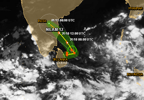
Image credit: GDACS
Coastal districts of Tamil Nadu and Andhra Pradesh in India braced for a Tropical Cyclone Nilam expected to make landfall tomorrow.
By JTWC report issued 15:00 UTC (October 30, 2012) Nilam was located approximately 265 NM southeast of Chennai, India, and has tracked northwestward at 06 knots over the past 6 hours. Animated multispectral satellite imagery along with microwave image revealed a broad yet defined low-level circulation center with deep central convection displaced to the west.
The Indian Meteorological Department (IMD) said the system was expected to move north-northwest and cross the coast near Chennai by the evening of October 31, 2012.

A bulletin issued by Area Cyclone Warning Centre said that ‘Nilam’, located over southwest Bay of Bengal, remained practically stationary and lay centered at 11:30 hours IST of today, October 30, 2012 about 500 km south-southeast of Chennai and 100 km east-northeast of Trincomalee (Sri Lanka). The system would move northwestwards and cross north Tamil Nadu and adjoining south Andhra Pradesh coast between Cuddalore and Nellore near Chennai by October 31, 2012 afternoon/evening.
Under the influence of this system, rainfall at most places with isolated heavy to very heavy rainfall would occur over coastal Tamil Nadu, Puducherry during next 12 hours. The intensity of rainfall would increase thereafter with scattered heavy to very heavy rainfall and isolated extremely heavy rainfall (25 cm or more) for subsequent 24 hrs. Rainfall at most places with isolated heavy to very heavy falls would also occur over south coastal Andhra Pradesh, Rayalaseema and north Interior Tamil Nadu during next 48 hours.
Squally winds speed reaching 45-55 km/h gusting to 65 km/h would prevail along and off north Tamil Nadu, Puducherry and adjoining south Andhra Pradesh coasts during next 06 hours. The wind speed would gradually increase thereafter as the system comes closer to coast, becoming 80-90 km/h at the time of landfall.
Sea condition will be very rough to high along and off north Tamil Nadu, Puducherry and adjoining south Andhra Pradesh coasts during next 36 hours.
Storm Surge: Storm surge of about 1 -1.5 metre over the astronomical tide is likely to inundate the low-lying areas of Chennai, Kanchipuram & Tiruvallur of Tamilnadu and Nellore district of Andhra Pradesh.
Damage expected as the cyclone approaches near the coast: Damage to thatched huts. Uprooting of small trees. Breaking of tree branches causing minor damage to power and communication lines at the time of landfall.


Over the last 24 hours, the northern coastal districts of Tamil Nadu, including Chennai, Kancheepuram and Cuddalore, received up to 15 centimeters (5.9 inches) of rain in some areas.
According to the IMD, a deep depression, a condition that precedes cyclonic winds, was noticed around the Bay of Bengal on Tuesday at 5:30 a.m. Indian Standard Time. In about three hours, the speed of wind exceeded 34 knots, about 63 kilometers per hour, the benchmark at which the storm can be classified as a cyclone.
GDACS estimated that up to 25.4 million people can be affected by wind speeds of tropical storm strength or above. In addition, 1.2 million people are living in coastal areas below 5m and can therefore be affected by storm surge.
Weather conditions are expected to be calmer by Thursday.
I'm a dedicated researcher, journalist, and editor at The Watchers. With over 20 years of experience in the media industry, I specialize in hard science news, focusing on extreme weather, seismic and volcanic activity, space weather, and astronomy, including near-Earth objects and planetary defense strategies. You can reach me at teo /at/ watchers.news.
[…] contrast, preparations for Nilam began quite late with a weak warning and very little information available to the public. Worse, between the IMD and state governments, […]
[…] contrast, preparations for Nilam began quite late with a weak warning and very little information available to the public. Worse, between the IMD and state governments, […]