
Magnitude 6.0 earthquake hit southeast of Loyalty Islands
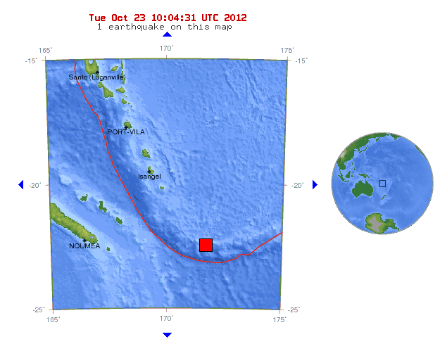
Image credit: USGS
A strong M6.0 earthquake struck southeast of the Loyalty Islands at 9:39 UTC on October 23, 2012.
Epicenter was located 398 km (247 miles) SE from Isangel, Vanuatu and 401 km (249 miles) ESE from Tadine, Loyalty Islands, New Caledonia; at coordinates 22.316°S, 171.675°E.
Recorded depth was 127 km (78.9 miles). EMSC reported it as M5.6 at a depth of 100 km.
There are just few people living within 100 km.
| Magnitude | 6.0 |
|---|---|
| Date-Time |
|
| Location | 22.316°S, 171.675°E |
| Depth | 127 km (78.9 miles) |
| Region | SOUTHEAST OF THE LOYALTY ISLANDS |
| Distances |
|
| Location Uncertainty | horizontal +/- 14.6 km (9.1 miles); depth +/- 6.3 km (3.9 miles) |
| Parameters | NST=325, Nph=333, Dmin=539.9 km, Rmss=0.9 sec, Gp= 25°, M-type=regional moment magnitude (Mw), Version=7 |
| Source |
|
| Event ID | usb000dbf7 |

Today's earthquakes before M6.0 southeast of Loyalty Islands. Updated at 10:04 UTC:
| MAG | UTC DATE-TIME y/m/d h:m:s | LAT deg | LON deg | DEPTH km | Region |
|---|---|---|---|---|---|
| 6.0 | 2012/10/23 09:39:31 | -22.316 | 171.675 | 127.0 | SOUTHEAST OF THE LOYALTY ISLANDS |
| 5.2 | 2012/10/23 09:33:20 | -57.575 | 148.078 | 10.0 | WEST OF MACQUARIE ISLAND |
| 5.9 | 2012/10/23 08:53:39 | 29.057 | 139.261 | 438.5 | IZU ISLANDS, JAPAN REGION |
| 2.5 | 2012/10/23 08:43:18 | 36.255 | -120.824 | 7.5 | CENTRAL CALIFORNIA |
| 3.0 | 2012/10/23 08:22:15 | 18.889 | -65.004 | 7.0 | VIRGIN ISLANDS REGION |
| 3.7 | 2012/10/23 07:45:52 | 40.316 | -124.527 | 10.5 | OFFSHORE NORTHERN CALIFORNIA |
| 2.6 | 2012/10/23 07:29:43 | 36.005 | -120.569 | 5.3 | CENTRAL CALIFORNIA |
| 2.8 | 2012/10/23 05:52:19 | 61.398 | -150.053 | 13.6 | SOUTHERN ALASKA |
| 4.4 | 2012/10/23 05:38:28 | -8.994 | 124.106 | 103.0 | KEPULAUAN ALOR, INDONESIA |
| 2.5 | 2012/10/23 05:22:05 | 36.297 | -120.859 | 8.0 | CENTRAL CALIFORNIA |
| 2.7 | 2012/10/23 04:37:57 | 35.577 | -120.880 | 5.1 | CENTRAL CALIFORNIA |
| 2.5 | 2012/10/23 03:55:47 | 38.766 | -122.741 | 2.3 | NORTHERN CALIFORNIA |
| 2.5 | 2012/10/23 02:10:08 | 58.059 | -152.767 | 96.0 | KODIAK ISLAND REGION, ALASKA |
| 4.7 | 2012/10/23 00:37:09 | 39.570 | 143.027 | 26.5 | OFF THE EAST COAST OF HONSHU, JAPAN |
| 4.5 | 2012/10/23 00:21:12 | 14.215 | -89.814 | 260.5 | GUATEMALA |
I'm a dedicated researcher, journalist, and editor at The Watchers. With over 20 years of experience in the media industry, I specialize in hard science news, focusing on extreme weather, seismic and volcanic activity, space weather, and astronomy, including near-Earth objects and planetary defense strategies. You can reach me at teo /at/ watchers.news.
Commenting rules and guidelines
We value the thoughts and opinions of our readers and welcome healthy discussions on our website. In order to maintain a respectful and positive community, we ask that all commenters follow these rules.