
Active volcanoes in the world: June 20 – June 26, 2012
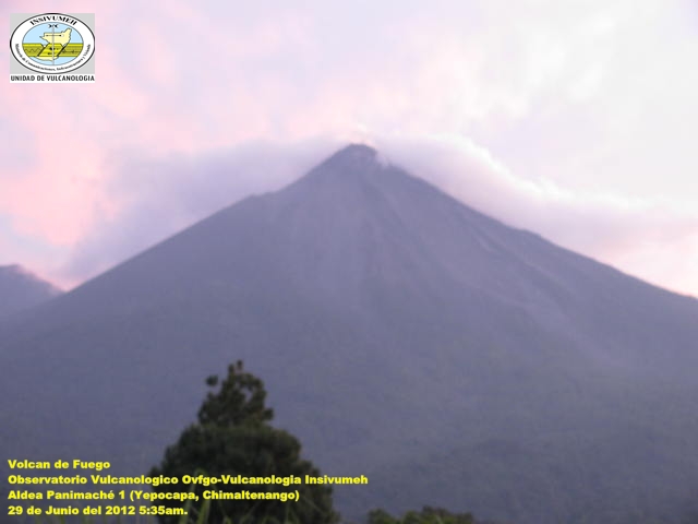
Image credit: Fuego on June 29, 2012 - INSIVUMEH
New unrest has been noticed around 3 volcanoes, ongoing activity was reported for 9 volcanoes. This report covers active volcanoes in the world recorded from June 20 – June 26, 2012 based on Smithsonian/USGS criteria.
FUEGO, Guatemala
14.473°N, 90.880°W; summit elev. 3763 m
INSIVUMEH reported that during 21-22 June weather conditions often prevented views of Fuego, however incandescence was observed emanating 150 m above the crater and an explosion produced an ash plume that rose 400 m. A lava flow traveled 1.3 km SSW down the Ceniza drainage and started a fire in a wooded area. Almost constant degassing on 21 June was heard at the Observatorio del Volcán de Fuego (OVFGO) and detected by the seismic network. During 24-26 June explosions generated ash plumes that rose 200-500 m above the crater. Incandescence from the crater was observed and block avalanches descended the flanks.
Geologic Summary. Volcán Fuego, one of Central America’s most active volcanoes, is one of three largestratovolcanoes overlooking Guatemala’s former capital, Antigua. The scarp of an older edifice, Meseta, lies between 3,763-m-high Fuego and its twin volcano to the N, Acatenango. Construction of Meseta volcano continued until the late Pleistocene or early Holocene, after which growth of the modern Fuego volcano continued the southward migration of volcanism that began at Acatenango. Frequent vigorous historical eruptions have been recorded at Fuego since the onset of the Spanish era in 1524, and have produced major ashfalls, along with occasional pyroclastic flows and lava flows. The last major explosive eruption from Fuego took place in 1974, producing spectacular pyroclastic flows visible from Antigua.
GALERAS, Colombia
1.22°N, 77.37°W; summit elev. 4276 m
INGEOMINAS reported that during 20-26 June the magnitude of earthquakes detected at Galeras had decreased since the previous week, but seismicity continued to indicate ash and gas emissions. During 19-22 and 24 June cameras recorded gas-and-ash emissions that drifted NW. The Alert Level remained at III (Yellow; “changes in the behavior of volcanic activity”).
Geologic Summary. Galeras, a stratovolcano with a large breached caldera located immediately W of the city of Pasto, is one of Colombia’s most frequently active volcanoes. The dominantly andesitic Galeras volcanic complex has been active for more than 1 million years, and two major caldera collapse eruptions took place during the late Pleistocene. Longterm extensive hydrothermal alteration has affected the volcano. This has contributed to large-scale edifice collapse that has occurred on at least three occasions, producing debris avalanches that swept to the W and left a large horseshoe-shaped caldera inside which the modern cone has been constructed. Major explosive eruptions since the mid Holocene have produced widespread tephra deposits and pyroclastic flows that swept all but the southern flanks. A central cone slightly lower than the caldera rim has been the site of numerous small-to-moderate historical eruptions since the time of the Spanish conquistadors.
NEVADO DEL RUIZ, Colombia
4.895°N, 75.322°W; summit elev. 5321 m
According to INGEOMINAS, the Observatorio Vulcanológico and Sismológico de Manizales reported that a high concentration of sulfur dioxide was detected during 20-22 June. Reports on 22 and 25 June stated that seismic signals had indicated continuing gas and ash emissions. Web camera images showed steam-and-gas plumes rising 300 m and drifting NW on both days. On 26 June seismicity was low. Sulfur dioxide emissions continued to be significant. The Alert Level remained at II (Orange; “eruption likely within days or weeks”) on 26 June.
Geologic Summary. Nevado del Ruiz is a broad, glacier-covered volcano in central Colombia that covers >200 sq km. Three major edifices, composed of andesitic and dacitic lavas and andesitic pyroclastics, have been constructed since the beginning of the Pleistocene. The modern cone consists of a broad cluster of lava domes built within the summit caldera of an older Ruiz volcano. The 1-km-wide, 240-m-deep Arenas crater occupies the summit. Steep headwalls of massive landslides cut the flanks of Nevado del Ruiz. Melting of its summit icecap during historical eruptions, which date back to the 16th century, has resulted in devastating lahars, including one in 1985 that was South America’s deadliest eruption.
SIPLE, West Antarctica
73.43°S, 126.67°W; summit elev. 3110 m
Infrared imagery from the Metop satellite showed a possible rising steam plume from the area of Siple on 20 June. The imagery, as interpreted by Mark Drapes, indicated that the volcano was about -22 degrees Celsius, about 6 degrees warmer that the surrounding landscape, and the base of the plume was about -55 degrees Celsius.
Geologic Summary. Mount Siple is a youthful-looking shield volcano that forms an island along the Pacific Ocean coast of Antarctica’s Marie Byrd Land. The massive 1800 cu km volcano is truncated by a 4-5 km summit calderaand is ringed by tuff cones at sea level. Its lack of dissection in a coastal area more susceptible to erosion than inland Antarctic volcanoes, and the existence of a satellite cone too young to date by the Potassium-Argon method, suggest a possible Holocene age (LeMasurier and Thomson 1990). The location of Mount Siple on published maps is 26 km NE of the actual location. A possible eruption cloud observed on satellite images on September 18 and October 4, 1988 was considered to result from atmospheric effects after low-level aerial observations revealed no evidence of recent eruptions (Smithsonian Scientific Event Alert Network Bulletin).
Ongoing activity
BATU TARA, Komba Island (Indonesia)
7.792°S, 123.579°E; summit elev. 748 m
Based on analyses of satellite imagery, the Darwin VAAC reported that on 19 June ash plumes from Batu Tara rose to an altitude of 2.4 km (8,000 ft) a.s.l. During 24-26 June ash plumes rose to an altitude of 1.8 km (6,000 ft) a.s.l. and drifted 15-95 km NNW and NW.
Geologic Summary. The small isolated island of Batu Tara in the Flores Sea about 50 km north of Lembata (formerly Lomblen) Island contains a scarp on the eastern side similar to the Sciara del Fuoco of Italy’s Stromboli volcano. Vegetation covers the flanks of Batu Tara to within 50 m of the 748-m-high summit. Batu Tara lies north of the main volcanic arc and is noted for its potassic leucite-bearing basanitic and tephritic rocks. The first historicaleruption from Batu Tara, during 1847-52, produced explosions and a lava flow.
CLEVELAND, Chuginadak Island
52.825°N, 169.944°W; summit elev. 1730 m
AVO reported that a small amount of ash from an explosion at Cleveland on 19 June was visible in satellite imagery drifting ESE. During 20-24 June thermal anomalies were detected in satellite imagery. On 21 June a small steam-and-gas plume was visible in web camera images. The Volcano Alert Level remained at Watch and the Aviation Color Code remained at Orange.
Geologic Summary. Symmetrical Mount Cleveland stratovolcano is situated at the western end of the uninhabited dumbbell-shaped Chuginadak Island in the east-central Aleutians. The 1,730-m-high stratovolcano is the highest of the Islands of Four Mountains group and is one of the most active in the Aleutians. Numerous large lava flows descend its flanks. It is possible that some 18th to 19th century eruptions attributed to Carlisle (a volcano located across the Carlisle Pass Strait to the NW) should be ascribed to Cleveland. In 1944 Cleveland produced the only known fatality from an Aleutian eruption. Recent eruptions from Mt. Cleveland have been characterized by short-lived explosive ash emissions, at times accompanied by lava fountaining and lava flows down the flanks.
KARYMSKY, Eastern Kamchatka (Russia)
54.05°N, 159.45°E; summit elev. 1536 m
KVERT reported that moderate seismic activity from Karymsky continued to be detected during 15-22 June, and indicated that possible ash plumes rose to an altitude of 3.6 km (11,800 ft) a.s.l. during 16-19 June. Satellite imagery showed a weak thermal anomaly on the volcano during 20-21 June. The Aviation Color Code remained at Orange.
Geologic Summary. Karymsky, the most active volcano of Kamchatka’s eastern volcanic zone, is a symmetricalstratovolcano constructed within a 5-km-wide caldera that formed about 7,600-7,700 radiocarbon years ago. Construction of the Karymsky stratovolcano began about 2,000 years later. The latest eruptive period began about 500 years ago, following a 2,300-year quiescence. Much of the cone is mantled by lava flows less than 200 years old. Historical eruptions have been Vulcanian or Vulcanian-Strombolian with moderate explosive activity and occasional lava flows from the summit crater. Most seismicity preceding Karymsky eruptions has originated beneath Akademia Nauk caldera, which is located immediately S of Karymsky volcano and erupted simultaneously with Karymsky in 1996.
KILAUEA, Hawaii (USA)
19.421°N, 155.287°W; summit elev. 1222 m
During 20-26 June HVO reported that the lava lake periodically rose and fell in the deep pit within Kilauea’s Halema’uma’u Crater. Occasional measurements indicated that the gas plume from the vent continued to deposit variable amounts of ash and Pele’s hair onto nearby areas. The lava pond in a small pit on the E edge of Pu’u ‘O’o crater floor and two vents along the S edge of the floor were visible with the web cameras. Lava flows were active on the coastal plain and traveled as far as 1 km from the ocean. Lava flows were also active on the pali.
Geologic Summary. Kilauea, one of five coalescing volcanoes that comprise the island of Hawaii, is one of the world’s most active volcanoes. Eruptions at Kilauea originate primarily from the summit caldera or along one of the lengthy E and SW rift zones that extend from the caldera to the sea. About 90% of the surface of Kilauea is formed of lava flows less than about 1,100 years old; 70% of the volcano’s surface is younger than 600 years. A long-term eruption from the East rift zone that began in 1983 has produced lava flows covering more than 100 sq km, destroying nearly 200 houses and adding new coastline to the island.
POPOCATEPETL, México
19.023°N, 98.622°W; summit elev. 5426 m
CENAPRED reported that during 20-25 June meteorological weather conditions often prevented observations of Popocatépetl’s crater. Emissions were detected by the seismic network and an occasional steam plume was seen rising from the crater. On 24 June a gas-and-steam plume containing a small amount of ash drifted NE and a dense gas-and-steam plume drifted SW. Incandescence from the crater was occasionally visible at night. The next day emissions sometimes contained small amounts of ash. On 26 June visibility improved. Increased incandescence from the crater was accompanied by gas and very dark ash emissions that rose 0.8-2 km above the crater. The Alert Level remained at Yellow Phase Three.
Geologic Summary. Popocatépetl, whose name is the Aztec word for smoking mountain, towers to 5,426 m 70 km SE of Mexico City and is North America’s second-highest volcano. Frequent historical eruptions have been recorded since the beginning of the Spanish colonial era. A small eruption on 21 December 1994 ended five decades of quiescence. Since 1996 small lava domes have incrementally been constructed within the summit crater and destroyed by explosive eruptions. Intermittent small-to-moderate gas-and-ash eruptions have continued, occasionally producing ashfall in neighboring towns and villages.
SAKURA-JIMA, Kyushu
31.585°N, 130.657°E; summit elev. 1117 m
Based on information from JMA, the Tokyo VAAC reported that on 20 and 22 June explosions from Sakura-jima produced plumes that rose to altitudes of 2.4-3.7 km (8,000-12,000 ft) a.s.l. and drifted E. A pilot observed an ash plume on 20 June that rose to an altitude of 3.7 (12,000 ft) a.s.l. and drifted E. JMA reported that during 22-25 June large explosive eruptions from Showa Crater occurred five times and ejected tephra as far as 1,300 m from the crater. According to VAAC reports on 26 June, explosions were detected and an ash plume rose to altitudes of 1.5-1.8 km (5,000-6,000 ft) a.s.l. and drifted W.
Geologic Summary. Sakura-jima, one of Japan’s most active volcanoes, is a post-caldera cone of the Aira calderaat the northern half of Kagoshima Bay. Eruption of the voluminous Ito pyroclastic flow was associated with the formation of the 17 x 23-km-wide Aira caldera about 22,000 years ago. The construction of Sakura-jima began about 13,000 years ago and built an island that was finally joined to the Osumi Peninsula during the major explosive and effusive eruption of 1914. Activity at the Kita-dake summit cone ended about 4,850 years ago, after which eruptions took place at Minami-dake. Frequent historical eruptions, recorded since the 8th century, have deposited ash on Kagoshima, one of Kyushu’s largest cities, located across Kagoshima Bay only 8 km from the summit. The largest historical eruption took place during 1471-76.
SANTA MARIA, Guatemala
14.756°N, 91.552°W; summit elev. 3772 m
INSIVUMEH reported that on 22 June an explosion from Santa María’s Santiaguito lava-dome complex produced an ash plume that rose 700 m above Caliente dome and drifted E and SE. Ashfall was reported in Santa María de Jesús. Block avalanches from the dome traveled down the SE flank. On 23 June lahars traveled S down the Rio Nima I and San Isidro drainages, carrying tree branches and blocks 30-80 cm in diameter. During 25-26 June an explosions generated an ash plume that rose 600 m and drifted SE. Ash fell on the San José and La Quina ranches. Block avalanches again traveled down the SE flank.
Geologic Summary. Symmetrical, forest-covered Santa María volcano is one of a chain of large stratovolcanoes that rises dramatically above the Pacific coastal plain of Guatemala. The stratovolcano has a sharp-topped, conical profile that is cut on the SW flank by a large, 1-km-wide crater, which formed during a catastrophic eruption in 1902 and extends from just below the summit to the lower flank. The renowned Plinian eruption of 1902 followed a long repose period and devastated much of SW Guatemala. The large dacitic Santiaguito lava-dome complex has been growing at the base of the 1902 crater since 1922. Compound dome growth at Santiaguito has occurred episodically from four westward-younging vents, accompanied by almost continuous minor explosions and periodic lava extrusion, larger explosions, pyroclastic flows, and lahars.
SHIVELUCH, Central Kamchatka (Russia)
56.653°N, 161.360°E; summit elev. 3283 m
KVERT reported that during 15-22 June explosive activity at Shiveluch continued. Visual observations revealed strong gas-and-steam activity on 15, 17, and 21 June; weather conditions prevented observations on the other days. A thermal anomaly on the lava dome was detected in satellite imagery during 15-17, 21, and 24 June. On 24 June video data showed ash plumes that rose to an altitude of 5.3 km (17,400 ft) a.s.l. Based on information from Yelizovo Airport (UHPP) and KEMSD, the Tokyo VAAC reported that ash plumes rose to altitudes of 5.2-9.8 km (17,000-32,000 ft) a.s.l. The Aviation Color Code remained at Orange.
Geologic Summary. The high, isolated massif of Shiveluch volcano (also spelled Sheveluch) rises above the lowlands NNE of the Kliuchevskaya volcano group and forms one of Kamchatka’s largest and most active volcanoes. The currently active Molodoy Shiveluch lava-dome complex was constructed during the Holocene within a large breached caldera formed by collapse of the massive late-Pleistocene Strary Shiveluch volcano. At least 60 large eruptions of Shiveluch have occurred during the Holocene, making it the most vigorous andesitic volcano of the Kuril-Kamchatka arc. Frequent collapses of lava-dome complexes, most recently in 1964, have produced large debris avalanches whose deposits cover much of the floor of the breached caldera. Intermittent explosive eruptions began in the 1990s from a new lava dome that began growing in 1980. The largest historical eruptions from Shiveluch occurred in 1854 and 1964.
TUNGURAHUA, Ecuador
1.467°S, 78.442°W; summit elev. 5023 m
IG reported that during 20-26 June visual observations of Tungurahua were limited due to cloud cover. Incandescence from the crater was observed at night on 20 June. An explosion on 21 June produced an ash plume that rose less than 1 km above the crater and drifted W. Small lahars descended the Achupashal and La Pirámide drainages on the NW flank on 24 June.
Geologic Summary. The steep-sided Tungurahua stratovolcano towers more than 3 km above its northern base. It sits ~140 km S of Quito, Ecuador’s capital city, and is one of Ecuador’s most active volcanoes. Historical eruptions have all originated from the summit crater. They have been accompanied by strong explosions and sometimes by pyroclastic flows and lava flows that reached populated areas at the volcano’s base. The last major eruption took place from 1916 to 1918, although minor activity continued until 1925. The latest eruption began in October 1999 and prompted temporary evacuation of the town of Baños on the N side of the volcano.
Source: Global Volcanism Program
I'm a dedicated researcher, journalist, and editor at The Watchers. With over 20 years of experience in the media industry, I specialize in hard science news, focusing on extreme weather, seismic and volcanic activity, space weather, and astronomy, including near-Earth objects and planetary defense strategies. You can reach me at teo /at/ watchers.news.
Commenting rules and guidelines
We value the thoughts and opinions of our readers and welcome healthy discussions on our website. In order to maintain a respectful and positive community, we ask that all commenters follow these rules.