
Active volcanoes in the world: May 9 – May 15, 2012
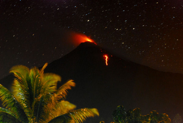
Featured image: Karangetang, Indonesia. Credit: www.lave.be
This report covers active volcanoes recorded from May 9 – May 15, 2012 based on Smithsonian/USGS criteria. New unrest has been noticed around 5 volcanoes, ongoing activity was reported for 9 volcanoes.
IJEN, Eastern Java, Indonesia
8.058°S, 114.242°E; summit elev. 2799 m
CVGHM reported that during 1-30 April white plumes from Ijen rose 100-200 m above the crater; during 1-11 May diffuse white plumes rose 50-100 m. From the beginning of April until 13 May the amplitude and number of earthquakes gradually decreased and the crater lake water temperature decreased by eight degrees Celsius. The Alert Level was lowered to 2 (on a scale of 1-4) on 13 May.
Geologic summary: The Ijen volcano complex consists of a group of small stratovolcanoes constructed within the large 20-km-wide Ijen (Kendeng) caldera. The N caldera wall forms a prominent arcuate ridge, but elsewhere the caldera rim is buried by post-caldera volcanoes, including Gunung Merapi stratovolcano, which forms the 2,799 m high point of the Ijen complex. Immediately W of Gunung Merapi is the renowned historically active Kawah Ijen volcano, which contains a nearly 1-km-wide, turquoise-colored, acid crater lake. The picturesque lake is the site of a labor-intensive sulfur mining operation, in which sulfur-laden baskets are hand-carried from the crater floor. A half dozen small-to-moderate phreatic eruptions have taken place from Kawah Ijen during the 20th century.
KARANGETANG , Siau, Indonesia
2.78°N, 125.40°E; summit elev. 1784 m
Based on analyses of satellite imagery, the Darwin VAAC reported that on 14 May an ash plume from Karangetang rose to an altitude of 3.7 km (12,000 ft) a.s.l. and drifted 130 km SE. On 16 May an ash plume again rose to an altitude of 3.7 km (12,000 ft) a.s.l. then drifted about 110 km SE.
Geologic summary: Karangetang (also known as Api Siau) lies at the northern end of the island of Siau, N of Sulawesi, and contains five summit craters strung along a N-S line. One of Indonesia’s most active volcanoes, Karangetang has had more than 40 recorded eruptions since 1675. Twentieth-century eruptions have included frequent explosions, sometimes accompanied by pyroclastic flows and lahars.
KARTHALA, Grand Comore Island
11.75°S, 43.38°E; summit elev. 2361 m
Observers in the villages of Mde and Mkazi, on the W flank of Karthala, reported increased incandescence from the summit during the night of 9-10 May.
Geologic summary: The southernmost and largest of the two shield volcanoes forming Grand Comore Island (also known as Ngazidja), Karthala contains a 3 x 4 km summit caldera generated by repeated collapse. Elongated riftzones extend to the NNW and SE from the summit of the Hawaiian-style shield, which has an asymmetrical profile that is steeper to the S. Historical eruptions have modified the morphology of the compound, irregular summit caldera. More than twenty eruptions have been recorded since the 19th century from both summit and flank vents. Many lava flows have reached the sea on both sides of the island, including during many 19th-century eruptions from the summit caldera and vents on the northern and southern flanks.
POPOCATEPETL, Mexico
México 19.023°N, 98.622°W; summit elev. 5426 m
CENAPRED reported that during 8-10 May multiple gas-and-ash plumes rose 1.5 km above Popocatépetl’s crater and drifted NE. Incandescent fragments ejected from the crater landed on the N and E flanks as far as 500 m away. According to a news article an airport in Puebla was closed due to ash plumes on 8 and 10 May. Seismicity increased on 11 May. Ash plumes rose 3 km above the crater and drifted NE and incandescent fragments ejected from the crater rolled 1 km down the flanks. Gas-and-ash plumes rose 2.5 km and drifted ENE. On 12 May gas-and-ash plumes rose 4 km above the crater. Incandescent tephra was ejected 2 km above the crater and again rolled 1 km down the flanks. Ashfall was reported in most municipalities within the state of Tlaxcala (50 km NE of the volcano), in addition to smaller towns nearer to the volcano such as Santiago Xalitzintla (15 km NE) and San Nicolás de los Ranchos (16 km ENE). An airport in Puebla was again closed due to ash. During 13-15 May gas-and-ash plumes rose from the crater and drifted NE, and incandescent tephra was ejected from the crater. The Alert Level remained at Yellow Phase Three.
Geologic summary: Popocatépetl, whose name is the Aztec word for smoking mountain, towers to 5,426 m 70 km SE of Mexico City and is North America’s second-highest volcano. Frequent historical eruptions have been recorded since the beginning of the Spanish colonial era. A small eruption on 21 December 1994 ended five decades of quiescence. Since 1996 small lava domes have incrementally been constructed within the summit crater and destroyed by explosive eruptions. Intermittent small-to-moderate gas-and-ash eruptions have continued, occasionally producing ashfall in neighboring towns and villages.
SIRUNG, Pantar Island (Indonesia)
8.508°S, 124.13°E; summit elev. 862 m
CVGHM reported that on 8 May a three-hour long ash eruption from Sirung was accompanied by loud sounds and incandescence that reached 10 m above the crater. An ash plume rose 3.5 km above the crater and drifted N, producing ashfall up to 4 mm thick near the crater. During 9-12 May white plumes rose 30-50 m above the crater. A sulfur odor was reported in areas up to 3 km away on 12 May. That same day CVGHM raised the Alert Level to 3 (on a scale of 1-4) and recommended that visitors not approach the volcano within a 2.5 km radius.
Based on a report from a ground-based observer and analyses of satellite imagery, the Darwin VAAC noted that on 12 May an ash plume rose to an altitude of 3 km (10,000 ft) a.s.l. and drifted about 95 km SW.
Geologic summary: Sirung volcano is located at the NE end of a 14-km-long line of volcanic centers that form a peninsula at the southern end of Pantar Island. The low, 862-m-high volcano is truncated by a 2-km-wide calderawhose floor often contains one or more small lakes. Much of the volcano is constructed of basaltic lava flows, and the Gunung Sirung lava dome forms the high point on the caldera’s western rim. A number of phreatic eruptions have occurred from vents within the caldera during the 20th century.
Ongoing activity
CLEVELAND, Chuginadak Island
52.825°N, 169.944°W; summit elev. 1730 m
AVO reported that during 9-12 and 15 May cloudy weather conditions prevented satellite observations of Cleveland’s summit crater. Elevated surface temperatures were detected in images on 13 May and possibly the next day. The Volcano Alert Level remained at Watch and the Aviation Color Code remained at Orange.
Geologic summary: Symmetrical Mount Cleveland stratovolcano is situated at the western end of the uninhabited dumbbell-shaped Chuginadak Island in the east-central Aleutians. The 1,730-m-high stratovolcano is the highest of the Islands of Four Mountains group and is one of the most active in the Aleutians. Numerous large lava flows descend its flanks. It is possible that some 18th to 19th century eruptions attributed to Carlisle (a volcano located across the Carlisle Pass Strait to the NW) should be ascribed to Cleveland. In 1944 Cleveland produced the only known fatality from an Aleutian eruption. Recent eruptions from Mt. Cleveland have been characterized by short-lived explosive ash emissions, at times accompanied by lava fountaining and lava flows down the flanks.
KARYMSKY, Eastern Kamchatka (Russia)
54.05°N, 159.45°E; summit elev. 1536 m
KVERT reported that moderate seismic activity from Karymsky continued to be detected during 4-11 May, and indicated that possible ash plumes rose to an altitude of 2 km (6,600 ft) a.s.l. during 7-8 May. Satellite imagery showed a daily thermal anomaly on the volcano. The Aviation Color Code remained at Orange.
Geologic summary: Karymsky, the most active volcano of Kamchatka’s eastern volcanic zone, is a symmetricalstratovolcano constructed within a 5-km-wide caldera that formed about 7,600-7,700 radiocarbon years ago. Construction of the Karymsky stratovolcano began about 2,000 years later. The latest eruptive period began about 500 years ago, following a 2,300-year quiescence. Much of the cone is mantled by lava flows less than 200 years old. Historical eruptions have been Vulcanian or Vulcanian-Strombolian with moderate explosive activity and occasional lava flows from the summit crater. Most seismicity preceding Karymsky eruptions has originated beneath Akademia Nauk caldera, which is located immediately S of Karymsky volcano and erupted simultaneously with Karymsky in 1996.
KILAUEA, Hawaii (USA)
19.421°N, 155.287°W; summit elev. 1222 m
During 9-15 May HVO reported that the circulating lava lake periodically rose and fell in the deep pit within Kilauea’s Halema’uma’u Crater. On 14 May laser measurements indicated that the lava-lake surface was about 67 m below the Halema’uma’u Crater floor. Almost daily measurements indicated that the gas plume from the vent continued to deposit variable amounts of ash, and occasionally fresh spatter from an active source at the SE edge of the lava lake, onto nearby areas. Incandescence was visible from both a lava pond in a small pit on the E edge and a small spatter cone on the SE edge of the Pu’u ‘O’o crater floor, and from two skylights on the uppermost part of the lava-tube system. Geologists observed slowly advancing lava flows on 13 May that were about 1.4 km from the coast. A short lava flow issued from an incandescent vent on the S part of Pu’u ‘O’o’s crater floor.
Geologic summary: Kilauea, one of five coalescing volcanoes that comprise the island of Hawaii, is one of the world’s most active volcanoes. Eruptions at Kilauea originate primarily from the summit caldera or along one of the lengthy E and SW rift zones that extend from the caldera to the sea. About 90% of the surface of Kilauea is formed of lava flows less than about 1,100 years old; 70% of the volcano’s surface is younger than 600 years. A long-term eruption from the East rift zone that began in 1983 has produced lava flows covering more than 100 sq km, destroying nearly 200 houses and adding new coastline to the island.
PAGAN, Mariana Islands
18.13°N, 145.80°E; summit elev. 570 m
According to NASA’s Earth Observatory, a satellite image of Pagan acquired on 7 May showed a gas-and-steam plume drifting W. The plume’s blue tint suggested the presence of sulfur dioxide; elevated levels of sulfur dioxide to the W of the volcano were detected in satellite images later that day. The USGS reported that minor steam-and-gas plumes were observed in partly cloudy satellite images during 4-11 May. The Volcano Alert Level remained at Advisory and the Aviation Color Code remained at Yellow.
Geologic summary: Pagan Island, the largest and one of the most active of the Mariana Islands volcanoes, consists of two stratovolcanoes connected by a narrow isthmus. Both North and South Pagan stratovolcanoes were constructed within calderas, 7 and 4 km in diameter, respectively. The 570-m-high Mount Pagan at the NE end of the island rises above the flat floor of the caldera, which probably formed during the early Holocene. South Pagan is a 548-m-high stratovolcano with an elongated summit containing four distinct craters. Almost all of the historicaleruptions of Pagan, which date back to the 17th century, have originated from North Pagan volcano. The largest eruption of Pagan during historical time took place in 1981 and prompted the evacuation of the sparsely populated island.
SAKURA-JIMA, Japan
Kyushu 31.585°N, 130.657°E; summit elev. 1117 m
JMA reported that during 11-15 May explosive eruptions from Sakura-jima’s Showa Crater occurred nine times and ejected tephra as far as 1.3 km from the crater. Based on information from JMA, the Tokyo VAAC reported that during 9 and 11-15 May explosions produced plumes that rose to altitudes of 1.8-2.7 km (6,000-9,000 ft) a.s.l. and drifted SW, S, SE, E, and N. A pilot observed an ash plume on 12 May that rose to an altitude of 2.1 (7,000 ft) a.s.l. and drifted E.
Geologic summary: Sakura-jima, one of Japan’s most active volcanoes, is a post-caldera cone of the Aira calderaat the northern half of Kagoshima Bay. Eruption of the voluminous Ito pyroclastic flow was associated with the formation of the 17 x 23-km-wide Aira caldera about 22,000 years ago. The construction of Sakura-jima began about 13,000 years ago and built an island that was finally joined to the Osumi Peninsula during the major explosive and effusive eruption of 1914. Activity at the Kita-dake summit cone ended about 4,850 years ago, after which eruptions took place at Minami-dake. Frequent historical eruptions, recorded since the 8th century, have depositedash on Kagoshima, one of Kyushu’s largest cities, located across Kagoshima Bay only 8 km from the summit. The largest historical eruption took place during 1471-76.
SANTA MARIA, Guatemala
14.756°N, 91.552°W; summit elev. 3772 m
INSIVUMEH reported that during 13-14 May incandescent explosions from Santa María’s Caliente dome producedash plumes that rose 700 m above the crater and drifted WSW. Avalanches from the dome and lava-flow fronts descended the flanks.
Geologic summary: Symmetrical, forest-covered Santa María volcano is one of a chain of large stratovolcanoesthat rises dramatically above the Pacific coastal plain of Guatemala. The stratovolcano has a sharp-topped, conical profile that is cut on the SW flank by a large, 1-km-wide crater, which formed during a catastrophic eruption in 1902 and extends from just below the summit to the lower flank. The renowned Plinian eruption of 1902 followed a long repose period and devastated much of SW Guatemala. The large dacitic Santiaguito lava-dome complex has been growing at the base of the 1902 crater since 1922. Compound dome growth at Santiaguito has occurred episodically from four westward-younging vents, accompanied by almost continuous minor explosions and periodiclava extrusion, larger explosions, pyroclastic flows, and lahars.
SHIVELUCH, Central Kamchatka (Russia)
56.653°N, 161.360°E; summit elev. 3283 m
KVERT reported that explosive activity at Shiveluch continued during 4-11 May. Ground-based observers and satellite imagery indicated that a viscous lava flow continued to effuse in the active crater and was accompanied byfumarolic activity. Seismic data and visual observations showed that ash plumes rose to altitudes of 10 and 5 km (32,800 and 16,400 ft) a.s.l. on 5 May and during 6-8 May, respectively. Satellite imagery showed a thermal anomaly on the lava dome during 4-5 and 8-10 May. Ash plumes drifted 800 km SE on 5 May, and an ash cloud 95 km SE of the volcano was observed on 7 May.
Geologic summary: The high, isolated massif of Shiveluch volcano (also spelled Sheveluch) rises above the lowlands NNE of the Kliuchevskaya volcano group and forms one of Kamchatka’s largest and most active volcanoes. The currently active Molodoy Shiveluch lava-dome complex was constructed during the Holocene within a large breached caldera formed by collapse of the massive late-Pleistocene Strary Shiveluch volcano. At least 60 large eruptions of Shiveluch have occurred during the Holocene, making it the most vigorous andesitic volcano of the Kuril-Kamchatka arc. Frequent collapses of lava-dome complexes, most recently in 1964, have produced large debris avalanches whose deposits cover much of the floor of the breached caldera. Intermittent explosive eruptions began in the 1990s from a new lava dome that began growing in 1980. The largest historical eruptions from Shiveluch occurred in 1854 and 1964.
SOUFRIERE HILLS, Montserrat
16.72°N, 62.18°W; summit elev. 915 m
MVO reported that during 4-11 May activity at the Soufrière Hills lava dome was at a low level. Multiple areas of incandescence on the lava dome, at temperatures greater that 500 degrees Celsius, were visible on 5 May. Heavy rains on 10 May generated a small lahar in the Belham Valley (NW). The Hazard Level remained at 2 (on a scale of 1-5).
Geologic summary: The complex dominantly andesitic Soufrière Hills volcano occupies the southern half of the island of Montserrat. The summit area consists primarily of a series of lava domes emplaced along an ESE-trending zone. English’s Crater, a 1-km-wide crater breached widely to the E, was formed during an eruption about 4,000 years ago in which the summit collapsed, producing a large submarine debris avalanche. Block-and-ash flow and surge deposits associated with dome growth predominate in flank deposits at Soufrière Hills. Non-eruptive seismic swarms occurred at 30-year intervals in the 20th century, but with the exception of a 17th-century eruption that produced the Castle Peak lava dome, no historical eruptions were recorded on Montserrat until 1995. Long-term small-to-moderate ash eruptions beginning in that year were later accompanied by lava-dome growth and pyroclastic flows that forced evacuation of the southern half of the island and ultimately destroyed the capital city of Plymouth, causing major social and economic disruption.
TUNGURAHUA, Ecuador
1.467°S, 78.442°W; summit elev. 5023 m
IG reported that during 9-15 May visual observations of Tungurahua were often limited due to cloud cover. On 10 May a steam plume with low ash content rose 200 m above the crater and drifted W. Seismicity increased on 12 May. Explosions caused windows to vibrate in areas near the volcano. Sounds resembling blocks rolling down the flanks as well as roaring noises were reported. A plume with low ash content rose 2-3 km above the crater and drifted W and NW. The next day a plume rose 200 m above the crater and drifted W.
Geologic summary: The steep-sided Tungurahua stratovolcano towers more than 3 km above its northern base. It sits ~140 km S of Quito, Ecuador’s capital city, and is one of Ecuador’s most active volcanoes. Historical eruptions have all originated from the summit crater. They have been accompanied by strong explosions and sometimes bypyroclastic flows and lava flows that reached populated areas at the volcano’s base. The last major eruption took place from 1916 to 1918, although minor activity continued until 1925. The latest eruption began in October 1999 and prompted temporary evacuation of the town of Baños on the N side of the volcano.
Source: Global Volcanism Program
I'm a dedicated researcher, journalist, and editor at The Watchers. With over 20 years of experience in the media industry, I specialize in hard science news, focusing on extreme weather, seismic and volcanic activity, space weather, and astronomy, including near-Earth objects and planetary defense strategies. You can reach me at teo /at/ watchers.news.
Commenting rules and guidelines
We value the thoughts and opinions of our readers and welcome healthy discussions on our website. In order to maintain a respectful and positive community, we ask that all commenters follow these rules.