
US: Severe weather outbreak expected this weekend
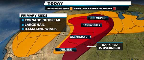
Image credit: weather.com
A tornado that cut through the heart of Norman on Friday, April 13, 2012 could be the first taste of a major outbreak expected Saturday and Sunday.
A large upper-air cold pocket will exit out of the Four Corners and meet up with a humid and very warm air mass still present across the Plains and parts of the mid-Mississippi Valley.
Other factors including an energetic jet stream energy and winds changing in direction with height will all lead to a much greater threat for tornadoes compared to earlier in the week.
The Friday tornado cut a roughly eight-mile path, dropping down about 4 p.m. near southwest Norman at Interstate 35 and W Lindsey Street. It hop-scotched through the center of town, tossing telephone poles, shredding trees, ripping the roofs off buildings and raking a park near the city’s municipal complex before fading out in the northeast side of the city.
At least 10 people were taken to Norman Regional Hospital with minor injuries like scrapes and bruises, said Kelly Wells, hospital spokeswoman. Deputy Fire Chief Jim Bailey said three individuals were taken to the hospital via ambulance, including two who were in a vehicle when the tornado hit and another person hit by debris. “It is surprising you don’t have more injured with the time of day, about 4:02,” Bailey said. “Norman is a busy town. There were a lot of people out driving around, and we had very little notification.”
Atmospheric conditions Saturday will be ripe for tornadoes and other severe weather, according to the National Weather Service. “The bottom line is, be ready for it. It may happen in one place, or it may happen across a huge part of the state, but it only takes one tornado and one storm,” said Rick Smith, a National Weather Service meteorologist.
Severe thunderstorms are possible throughout the state Saturday, but the Oklahoma City area and most of the middle third of the state are in an area deemed at the highest risk. Storms are expected to form in the late afternoon or early evening and track across the state, forecasters said.
Tornadoes, damaging straight-line winds, lightning, hail and flooding rain are possible. “If everything comes together like it could, it could be a serious situation for parts of Oklahoma,” Smith said.
In Norman on Friday, the University of Oklahoma had no reports of damage, a spokeswoman said, but other areas weren’t so lucky. Smith said the most significant structural damage was found near the health system at N Porter Avenue and E Robinson Street. Bailey said the tornado ripped the trees out at Andrews Park near the municipal complex. Philip DeFatta, owner of Leon Pierce Body Shop, 521 N Porter, said he took cover inside his shop. While he did not hear the tornado, he heard the medical records building next door explode.
Sources: weather.com, RSOE
I'm a dedicated researcher, journalist, and editor at The Watchers. With over 20 years of experience in the media industry, I specialize in hard science news, focusing on extreme weather, seismic and volcanic activity, space weather, and astronomy, including near-Earth objects and planetary defense strategies. You can reach me at teo /at/ watchers.news.
Commenting rules and guidelines
We value the thoughts and opinions of our readers and welcome healthy discussions on our website. In order to maintain a respectful and positive community, we ask that all commenters follow these rules.