
Active volcanoes in the world – March 28 – April 3, 2012
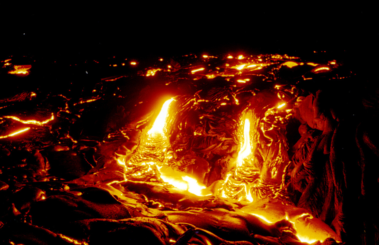
Image credit: Eruption of the Kilauea Volcono, Hawai`i, Adrian Glover
This report covers active volcanoes recorded from March 28 – April 3, 2012 based on Smithsonian/USGS criteria. New unrest has been noticed around 7 volcanoes, ongoing activity was reported for 8 volcanoes.
CLEVELAND
Chuginadak Island 52.825°N, 169.944°W; summit elev. 1730 m
AVO reported that on 28 March the Volcano Alert Level for Cleveland was raised to Watch and the Aviation Color Code was raised to Orange due to the formation of a new lava dome, observed in satellite imagery, which extruded in the summit crater during the previous week. During 29 March-3 April cloud cover prevented observations of the crater. Elevated surface temperatures consistent with a hot lava dome were detected in infrared satellite imagery on 4 April. No seismic information was available because Cleveland does not have a real-time seismic network.
Geologic summary: Symmetrical Mount Cleveland stratovolcano is situated at the western end of the uninhabited dumbbell-shaped Chuginadak Island in the east-central Aleutians. The 1,730-m-high stratovolcano is the highest of the Islands of Four Mountains group and is one of the most active in the Aleutians. Numerous large lava flows descend its flanks. It is possible that some 18th to 19th century eruptions attributed to Carlisle (a volcano located across the Carlisle Pass Strait to the NW) should be ascribed to Cleveland. In 1944 Cleveland produced the only known fatality from an Aleutian eruption. Recent eruptions from Mt. Cleveland have been characterized by short-lived explosive ash emissions, at times accompanied by lava fountaining and lava flows down the flanks.
FUEGO
Guatemala 14.473°N, 90.880°W; summit elev. 3763 m
INSIVUMEH reported that during 31 March-1 April and 3-4 April explosions from Fuego produced ash plumes that rose 500-800 m above the crater and drifted 10 km W and NW. During the night lava fountains rose 100-150 m above the crater and formed avalanches that traveled towards the Río Cenizas drainage. Based on analysis of satellite imagery, the Washington VAAC reported that on 1 April an ash plume drifted 13 km WSW and a well-defined thermal anomaly was observed.
Geologic summary: Volcán Fuego, one of Central America’s most active volcanoes, is one of three largestratovolcanoes overlooking Guatemala’s former capital, Antigua. The scarp of an older edifice, Meseta, lies between 3,763-m-high Fuego and its twin volcano to the N, Acatenango. Construction of Meseta volcano continued until the late Pleistocene or early Holocene, after which growth of the modern Fuego volcano continued the southward migration of volcanism that began at Acatenango. Frequent vigorous historical eruptions have been recorded at Fuego since the onset of the Spanish era in 1524, and have produced major ashfalls, along with occasional pyroclastic flows and lava flows. The last major explosive eruption from Fuego took place in 1974, producing spectacular pyroclastic flows visible from Antigua.
ILIAMNA
Southwestern Alaska 60.032°N, 153.090°W; summit elev. 3053 m
AVO reported that during 28 March-3 April seismicity at Iliamna remained above background levels, although just slightly, during 25-27 March. When not obscured by clouds, satellite and web camera views showed nothing unusual. The Alert Level remained at Advisory and the Aviation Color Code remained at Yellow.
Geologic summary: Iliamna is a prominent, 3053-m-high glacier-covered stratovolcano in Lake Clark National Park on the western side of Cook Inlet, about 225 km SW of Anchorage. Its flat-topped summit is flanked on the south, along a 5-km-long ridge, by the prominent North and South Twin Peaks, satellitic lava dome complexes. The Johnson Glacier dome complex lies on the NE flank. Steep headwalls on the southern and eastern flanks expose an inaccessible cross-section of the volcano. Major glaciers radiate from the summit, and valleys below the summit contain debris-avalanche and lahar deposits. Only a few major Holocene explosive eruptions have occurred from the deeply dissected volcano, which lacks a distinct crater. Most of the reports of historical eruptions may represent plumes from vigorous fumaroles east and SE of the summit, which are often mistaken for eruption columns (Miller et al., 1998). Eruptions producing pyroclastic flows have been dated at as recent as about 300 and 140 years ago (into the historical period), and elevated seismicity accompanying dike emplacement beneath the volcano was recorded in 1996.
LEWOTOBI
Flores Island (Indonesia) 8.542°S, 122.775°E; summit elev. 1703 m
CVGHM reported that seismicity at Lewotobi Lakilaki, one of two stratovolcanoes comprising Lewotobi, fluctuated but declined overall during 18 September 2011-25 March 2012. No significant changes were observed at the volcano. The Alert Level was lowered to 1 (on a scale of 1-4) on 29 March.
Observers of Lewotobi Perempuan, the second stratovolcano comprising Lewotobi, noted that during January-March diffuse white plumes rose 15 m above the crater and no significant changes had occurred. After 31 August 2011 through 25 March 2012 seismicity fluctuated but declined overall. On 29 March the Alert Level was lowered to 1.
Geologic summary: The Lewotobi “husband and wife” twin volcano (also known as Lewetobi) in eastern Flores Island is composed of the Lewotobi Lakilaki and Lewotobi Perempuan stratovolcanoes. Their summits are less than 2 km apart along a NW-SE line. The conical 1,584-m-high Lewotobi Lakilaki has been frequently active during the 19th and 20th centuries, while the taller and broader 1,703-m-high Lewotobi Perempuan has erupted only twice in historical time. Small lava domes have grown during the 20th century in the crescentic summit craters of both volcanoes, which are open to the N. A prominent flank cone, Iliwokar, occurs on the E flank of Lewotobi Perampuan.
NEVADO DEL RUIZ
Colombia 4.895°N, 75.322°W; summit elev. 5321 m
According to INGEOMINAS, the Observatorio Vulcanológico and Sismológico de Manizales reported that during 24-31 March seismicity at Nevado del Ruiz increased significantly. Earthquakes indicating rock fracturing occurred W of Arenas crater, exhibiting a pattern observed prior to the eruptions in 1985 and 1989, although less energetic. Starting at 1054 on 29 March, and lasting for about 25 minutes, more than 135 earthquakes were detected S of Arenas crater at a depth of 4 km. At 0400 on 31 March earthquake signals indicating rock fracturing and fluid movement markedly increased. The Alert Level was raised to II (Orange; “eruption likely within days or weeks”). Seismicity remained elevated during 1-3 April; earthquakes were located below Arenas crater at depths between 0.5 and 3 km.
Geologic summary: Nevado del Ruiz is a broad, glacier-covered volcano in central Colombia that covers >200 sq km. Three major edifices, composed of andesitic and dacitic lavas and andesitic pyroclastics, have been constructed since the beginning of the Pleistocene. The modern cone consists of a broad cluster of lava domes built within the summit caldera of an older Ruiz volcano. The 1-km-wide, 240-m-deep Arenas crater occupies the summit. Steep headwalls of massive landslides cut the flanks of Nevado del Ruiz. Melting of its summit icecap during historical eruptions, which date back to the 16th century, has resulted in devastating lahars, including one in 1985 that was South America’s deadliest eruption.
SOUFRIERE HILLS
Montserrat 16.72°N, 62.18°W; summit elev. 915 m
MVO reported that during 24-30 March activity at the Soufrière Hills lava dome was generally at a low level and no ash-venting episodes had been detected since 23 March. The average sulfur dioxide emission rate measured during the week was 1,320 tonnes per day with a minimum of 264 and a maximum of 4,594, which was the third-highest value recorded in the last ten years. High values occurred between 24 and 26 March, averaging 2,550 tonnes per day over the three days. The average for the rest of the week was around 400 tonnes per day. The Hazard Level remained at 2.
Geologic summary: The complex dominantly andesitic Soufrière Hills volcano occupies the southern half of the island of Montserrat. The summit area consists primarily of a series of lava domes emplaced along an ESE-trending zone. English’s Crater, a 1-km-wide crater breached widely to the E, was formed during an eruption about 4,000 years ago in which the summit collapsed, producing a large submarine debris avalanche. Block-and-ash flow and surge deposits associated with dome growth predominate in flank deposits at Soufrière Hills. Non-eruptive seismic swarms occurred at 30-year intervals in the 20th century, but with the exception of a 17th-century eruption that produced the Castle Peak lava dome, no historical eruptions were recorded on Montserrat until 1995. Long-term small-to-moderate ash eruptions beginning in that year were later accompanied by lava-dome growth andpyroclastic flows that forced evacuation of the southern half of the island and ultimately destroyed the capital city of Plymouth, causing major social and economic disruption.
SUNDORO
Central Java (Indonesia) 7.30°S, 109.992°E; summit elev. 3136 m
CVGHM reported that seismicity at Sundoro continued to increase into January after the Alert Level was raised from 1 to 2 (on a scale of 1-4) on 5 December 2011. After the first week of January through 27 March the number of daily earthquakes significantly decreased. The Alert Level was lowered to 1 on 30 March.
Geologic summary: Gunung Sundoro, one Java’s most symmetrical volcanoes, is separated by a 1400-m-high saddle from Sumbing volcano. Parasitic craters and cones, the largest of which is Kembang, occur on the NW-to-southern flanks, and all fed lava flows. A small lava dome occupies the summit crater of the 3136-m-high volcano, and numerous phreatic explosion vents were formed along radial fissure that cut the dome and extend across the crater rim. Lava flows extend in all directions from the summit crater. Deposits of a large prehistoric debris avalanche are located below the NE flank of Sundoro. Pyroclastic-flow deposits dated at 1720 years before present extend as far as 13 km from the summit. Historical eruptions typically have consisted of mild-to-moderate phreatic explosions, mostly from the summit crater. Flank vents were also active in 1882 and 1903.
Ongoing Activity
ETNA
Sicily (Italy) 37.734°N, 15.004°E; summit elev. 3330 m
Sezione di Catania – Osservatorio Etneo reported that the twenty-third paroxysmal eruptive episode since January 2011 took place at New SE Crater (New SEC) of Etna during the morning of 1 April following two weeks of quiescence. The episode was characterized by tall lava fountains from vents within the crater and on the SE flank of its cone, a gas-and-tephra plume, and lava flows descending toward the Valle del Bove. The paroxysmal phase lasted about 1.5 hours and ended just before daybreak. Ash and lapilli fell over the SE sector of the volcano, affecting mainly the area between Monterosso and Zafferana Etnea, but also the area between Acireale and Giarre, further downslope.
Geologic summary: Mount Etna, towering above Catania, Sicily’s second largest city, has one of the world’s longest documented records of historical volcanism, dating back to 1500 BC. Historical lava flows cover much of the surface of this massive basaltic stratovolcano, the highest and most voluminous in Italy. Two styles of eruptive activity typically occur at Etna. Persistent explosive eruptions, sometimes with minor lava emissions, take place from one or more of the three prominent summit craters, the Central Crater, NE Crater, and SE Crater. Flank eruptions, typically with higher effusion rates, occur less frequently and originate from fissures that open progressively downward from near the summit. A period of more intense intermittent explosive eruptions from Etna’s summit craters began in 1995. The active volcano is monitored by the Instituto Nazionale di Geofisica e Volcanologia (INGV) in Catania.
KARYMSKY
Eastern Kamchatka (Russia) 54.05°N, 159.45°E; summit elev. 1536 m
KVERT reported that during 23-30 March seismic activity from Karymsky continued to be detected, and indicated that possible ash plumes rose to an altitude of 2.5 km (8,200 ft) a.s.l. during 22-26 March. Satellite imagery showed a thermal anomaly on the volcano almost daily. The Aviation Color Code remained at Orange.
Geologic summary: Karymsky, the most active volcano of Kamchatka’s eastern volcanic zone, is a symmetricalstratovolcano constructed within a 5-km-wide caldera that formed about 7,600-7,700 radiocarbon years ago. Construction of the Karymsky stratovolcano began about 2,000 years later. The latest eruptive period began about 500 years ago, following a 2,300-year quiescence. Much of the cone is mantled by lava flows less than 200 years old. Historical eruptions have been Vulcanian or Vulcanian-Strombolian with moderate explosive activity and occasional lava flows from the summit crater. Most seismicity preceding Karymsky eruptions has originated beneath Akademia Nauk caldera, which is located immediately S of Karymsky volcano and erupted simultaneously with Karymsky in 1996.
KILAUEA
Hawaii (USA) 19.421°N, 155.287°W; summit elev. 1222 m
During 28 March-3 April HVO reported that the lava lake periodically rose and fell in the deep pit within Kilauea’s Halema’uma’u Crater. Almost daily measurements indicated that the gas plume from the vent continued to deposit variable amounts of ash nearby. Incandescence was visible from both a small pit on the NE edge and a smallspatter cone on the SE edge of the Pu’u ‘O’o crater floor, and on the upper part of the lava-tube system on the E flank. Lava flows continued to advance down the pali and across the coastal plain, reaching about 1.6 km from the coast. On 2 April a small lava flow issued from a vent on the S edge of the Pu’u ‘O’o crater floor.
Geologic summary: Kilauea, one of five coalescing volcanoes that comprise the island of Hawaii, is one of the world’s most active volcanoes. Eruptions at Kilauea originate primarily from the summit caldera or along one of the lengthy E and SW rift zones that extend from the caldera to the sea. About 90% of the surface of Kilauea is formed of lava flows less than about 1,100 years old; 70% of the volcano’s surface is younger than 600 years. A long-term eruption from the East rift zone that began in 1983 has produced lava flows covering more than 100 sq km, destroying nearly 200 houses and adding new coastline to the island.
POPOCATEPETL
México 19.023°N, 98.622°W; summit elev. 5426 m
CENAPRED reported that during 27 March-3 April steam-and-gas emissions rose from Popocatépetl. Emissions contained small amounts of ash on 28 and 30 March and crater incandescence was observed at night during 31 March-3 April.
Geologic summary: Popocatépetl, whose name is the Aztec word for smoking mountain, towers to 5,426 m 70 km SE of Mexico City and is North America’s second-highest volcano. Frequent historical eruptions have been recorded since the beginning of the Spanish colonial era. A small eruption on 21 December 1994 ended five decades of quiescence. Since 1996 small lava domes have incrementally been constructed within the summit crater and destroyed by explosive eruptions. Intermittent small-to-moderate gas-and-ash eruptions have continued, occasionally producing ashfall in neighboring towns and villages.
PUYEHUE-CORDON CAULLE
Central Chile 40.590°S, 72.117°W; summit elev. 2236 m
OVDAS–SERNAGEOMIN reported that during 27 March-3 April satellite and web camera observations of the Cordón Caulle rift zone, part of the Puyehue-Cordón Caulle volcanic complex, showed plumes that rose no higher than 1.2 km above the crater. Incandescence from the crater was observed every night. The Alert Level remained at Orange.
Geologic summary: The Puyehue-Cordón Caulle volcanic complex (PCCVC) is a large NW-SE-trending late-Pleistocene to Holocene basaltic-to-rhyolitic transverse volcanic chain SE of Lago Ranco. The 1799-m-highPleistocene Cordillera Nevada caldera lies at the NW end, separated from Puyehue stratovolcano at the SE end by the Cordón Caulle fissure complex. The Pleistocene Mencheca volcano with Holocene flank cones lies NE of Puyehue. The basaltic-to-rhyolitic Puyehue volcano is the most geochemically diverse of the PCCVC. The flat-topped, 2236-m-high Puyehue volcano was constructed above a 5-km-wide caldera and is capped by a 2.4-km-wide summit caldera of Holocene age. Lava flows and domes of mostly rhyolitic composition are found on the eastern flank of Puyehue. Historical eruptions originally attributed to Puyehue, including major eruptions in 1921-22 and 1960, are now known to be from the Cordón Caulle rift zone. The Cordón Caulle geothermal area, occupying a 6 x 13 km wide volcano-tectonic depression, is the largest active geothermal area of the southern Andes volcanic zone.
SHIVELUCH
Central Kamchatka (Russia) 56.653°N, 161.360°E; summit elev. 3283 m
KVERT reported that explosive activity at Shiveluch continued during 23-30 March. Ground-based observers and satellite imagery indicated that a viscous lava flow continued to effuse in the crater formed during a 2010 eruption. During 25-26 and 28 March ash plumes rose to an altitude of 7 km (23,000 ft) a.s.l. Satellite imagery showed a weak thermal anomaly daily on the volcano and ash plumes that drifted 192 km E and SE during 25-28 March. TheAviation Color Code remained at Orange.
Geologic summary: The high, isolated massif of Shiveluch volcano (also spelled Sheveluch) rises above the lowlands NNE of the Kliuchevskaya volcano group and forms one of Kamchatka’s largest and most active volcanoes. The currently active Molodoy Shiveluch lava-dome complex was constructed during the Holocene within a large breached caldera formed by collapse of the massive late-Pleistocene Strary Shiveluch volcano. At least 60 large eruptions of Shiveluch have occurred during the Holocene, making it the most vigorous andesitic volcano of the Kuril-Kamchatka arc. Frequent collapses of lava-dome complexes, most recently in 1964, have produced large debris avalanches whose deposits cover much of the floor of the breached caldera. Intermittent explosive eruptions began in the 1990s from a new lava dome that began growing in 1980. The largest historical eruptions from Shiveluch occurred in 1854 and 1964.
TENGGER CALDERA
Eastern Java (Indonesia) 7.942°S, 112.95°E; summit elev. 2329 m
CVGHM reported that during 1 January-29 March white plumes from Tengger Caldera’s Bromo cone rose 50 m above the crater and seismicity declined. On 30 March the Alert Level was lowered to 1 (on a scale of 1-4).
Geologic summary: The 16-km-wide Tengger caldera in eastern Java is located at the northern end of a volcanic massif extending from Semeru volcano. The massive Tengger volcanic complex consists of five overlapping stratovolcanoes, each truncated by a caldera. The most recent is the 9 x 10 km wide Sandsea caldera, which formed incrementally during the late Pleistocene and early Holocene. An overlapping cluster of post-caldera cones was constructed on the floor of the Sandsea caldera within the past several thousand years. The youngest of these is Bromo, one of Java’s most frequently visited and most active volcanoes. More than 50 mild-to-moderate explosive eruptions have occurred since 1804.
TUNGURAHUA
Ecuador 1.467°S, 78.442°W; summit elev. 5023 m
IG reported that during 28 March-3 April visual observations of Tungurahua were mostly limited due to cloud cover. A plume rose 800 m above the crater on 1 April and ashfall was reported in Pillate (7 km W), Choglontus (13 km WSW), and Motilones (W). Lahars descended the Pingullo and Achupashal (NW) drainages, carrying material 30 cm in diameter and causing a temporary road closure.
Geologic summary: The steep-sided Tungurahua stratovolcano towers more than 3 km above its northern base. It sits ~140 km S of Quito, Ecuador’s capital city, and is one of Ecuador’s most active volcanoes. Historical eruptions have all originated from the summit crater. They have been accompanied by strong explosions and sometimes bypyroclastic flows and lava flows that reached populated areas at the volcano’s base. The last major eruption took place from 1916 to 1918, although minor activity continued until 1925. The latest eruption began in October 1999 and prompted temporary evacuation of the town of Baños on the N side of the volcano.
Source: Global Volcanism Program
I'm a dedicated researcher, journalist, and editor at The Watchers. With over 20 years of experience in the media industry, I specialize in hard science news, focusing on extreme weather, seismic and volcanic activity, space weather, and astronomy, including near-Earth objects and planetary defense strategies. You can reach me at teo /at/ watchers.news.
Nevado del Huila, located south west in Colombia, is also increasing activity.Please check at the Smithsonian latest reports.