
The glaciers on the islands of Franz Josef are currently in a state of retreat
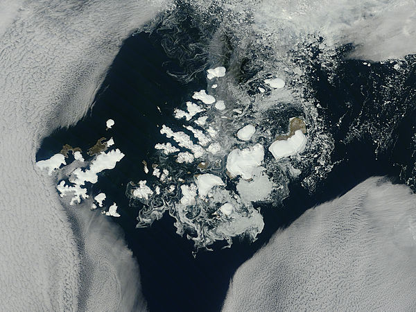
Image credit: TW
The clouds parted over the northeast Barents Sea region of the Arctic Ocean in late summer, 2011 allowing a view of the ice-covered islands of Franz Josef Land, Russia forming a stark-white contrast to the surrounding dark sea water. The Moderate Resolution Imaging Spectroradiometer (MODIS) aboard the Terra satellite captured this true-color image on August 14, 2011.
Franz Josef Land is an archipelago of 6 main islands and about 135 small islands, with a total landmass of about 16,134 square kilometers (6,229 square miles). The terrain is primarily elevated table lands and low hills, with the highest point rising to 620 m (998 mi).
The glaciers on the islands of Franz Josef are currently in a state of retreat, and in this image large areas of the main islands clearly appear ice free. However, up to 85% of the island’s landmass is permanently ice-covered, with an average ice thickness of about 180 m (590 feet). On Graham Bell Island (the large island on the eastern edge of the group, the Windy Dome Ice Cap reaches a depth of greater than 500 m (1,640 feet). Although it is late summer, sea ice can still be seen surrounding many of the islands. (MODIS)
Commenting rules and guidelines
We value the thoughts and opinions of our readers and welcome healthy discussions on our website. In order to maintain a respectful and positive community, we ask that all commenters follow these rules.