
Concern over Mt. Baekdu eruption growing
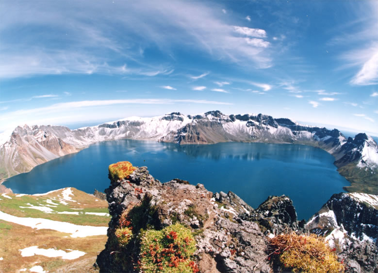
Image credit: TW
A slew of the latest environmental changes revealed by North Korean officials during a meeting with their South Korean counterparts in Munsan, north of Seoul, has put greater weight that the dormant volcano on Mt. Baekdu could erupt. It last erupted in 1903.
Volcanologists from the North cited snowfall in Gaeseong in late March as an unusual environmental change that they said was unprecedented in the relatively southern part of North Korea. Yoon Young-geun, a North Korean volcanologist, also said that following the quake in Japan, they observed underground water shaking and splashing up to 60 centimeters, with usually clean water from wells occasionally turning muddy. He said all of the abnormal events seem to be related to the 9.0-magnitude earthquake that hit northeastern Japan on March 11.
Many South Korean scientists have cautiously raised speculation that an eruption could take place in four to five years. They have claimed “strange signs,” including minor trembling near Mt. Baekdu in June 2002, and the frequency has increased. A Chinese institute monitoring volcanic activity at Mt. Baekdu acknowledged minor quakes which are too weak to be felt by human beings occur nearly 100 times per day. Among other indicators foreshadowing a future eruption is the height of Mt. Baekdu, which has grown nearly 10 centimeters since 2002.
Scientists said bloated magma, a precondition for an eruption, is gradually increasing the height of the mountain as well as raising the temperature on the surface. According to a simulation analysis, a large-scale eruption at Mt. Baekdu would send millions of tons of volcanic ash into the air. This huge mass, the analysis showed, would block the sun on the Korean Peninsula for about two months, resulting in the average temperature dropping by two degrees Celsius. South Korea’s weather agency has pushed to forge a partnership with its counterparts in Japan and China for more accurate weather forecasting including a natural disaster control system.
Small-scale eruptions at Mt. Baekdu were recorded in 1413, 1597, 1668 and 1702 ㅡ the last activity was recorded in 1903. Meanwhile, 13 dormant volcanoes in Japan are increasingly showing signs of eruption in the wake of the March 11 quake. (KoreaTimes)

It would be difficult to find a Korean (either from the South or the North) who hasn’t heard of Baekdu Mountain. It is regarded as the most sacred peak of the Korean Peninsula, and Koreans believe it to be the location of the nation’s origin. Baekdu Mountain was bound to be famous ― at the very least because it’s the highest peak in Korea. The 2,744-meter high mountain is situated on the border of China and North Korea, with two thirds of it in North Korean territory. It is among the 10 most famous mountains of China. But for Koreans, it will always be Mountain Number 1.
Its Korean name means “white-headed mountain.” In China it is known as the “perpetually white mountain” or “Changbaishan.” It looks white throughout the year despite not always being covered with snow due to the abundant pumice on its slopes. The lake, situated 2,189 meters above sea level, was formed in a crater. Its average depth is about 200 meters, with a maximum depth of 373 meters. A display near Cheonji boasts it to be the highest lake of volcanic origin. Tourists do not typically swim in the lake, as it rarely gets warmer than 10 degrees Celsius, even in summer.
Baekdu Mountain is a stratovolcano whose cone is truncated by a large caldera, about 5 km (3.1 miles) wide and 850 m (2,789 ft) deep, partially filled by the waters of Heaven Lake. The caldera was created by a major eruption in 969 AD (± 20 years). Volcanic ash from this eruption has been found as far away as the southern part of Hokkaidō, the northern island of Japan. The lake has a circumference of 12 to 14 kilometres (7.5-8.7 miles), with an average depth of 213 m (699 ft) and maximum depth of 384 m (1,260 ft). From mid-October to mid-June, the lake is typically covered with ice. In 2011, experts in North and South Korea met to discuss the potential for a significant eruption in the near future.
The central section of the mountain rises about 3 mm every year, due to rising levels of magma below the central part of the mountain. Sixteen peaks exceeding 2,500 m (8,200 ft) line the caldera rim surrounding Heaven Lake. The highest peak, called Janggun Peak, is covered in snow about eight months of the year. The slope is relatively gentle until about 1,800 metres (5,905 ft).
Water flows north out of the lake, and near the outlet there is a 70 metre (230 ft) waterfall. The mountain is the source of the Songhua, Tumen (Duman) and Yalu (Amnok) rivers.
Commenting rules and guidelines
We value the thoughts and opinions of our readers and welcome healthy discussions on our website. In order to maintain a respectful and positive community, we ask that all commenters follow these rules.