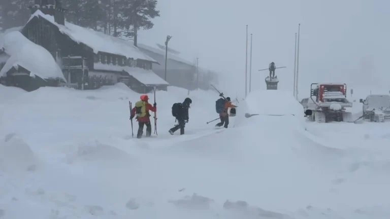
• Extreme winter storm impacts expected in Sierra Nevada as Pacific storms bring up to 2.4 m (8 feet) of snow through February 18

    Multiple storms are forecast to bring heavy snowfall to California through February 18, 2026, with snowfall rates exceeding 76 mm (3 inches) per hour in parts of the Sierra Nevada. Extreme impacts are possible across higher elevations, with travel conditions dangerous to impossible, and 1.2–2.4 m (4–8 feet) of snow forecast above pass level.

  • Evacuation Warnings issued for Palisades and Eaton burn scars ahead of high-impact winter storm in California

    Evacuation Warnings were issued for residents living near the Palisades and Eaton burn scar areas in Los Angeles County, California, effective from 21:00 LT (05:00 UTC) on Sunday, February 15, through 09:00 LT (17:00 UTC) on Tuesday, February 17, 2026, ahead of a winter storm forecast to bring heavy rainfall. Officials warned that debris flows and mudflows could damage property and pose life-threatening risks in recently burned areas. Winter storm warnings were also issued across parts of California and Nevada for heavy mountain snowfall and strong winds.

  • Cross-country storm to bring heavy rain to the South and snow to the West and Great Lakes

    An atmospheric river affecting California on February 11, 2026, is forecast to evolve into a cross-country storm moving across the southern U.S. through February 13–14, 2026. Widespread rainfall totals of 25 to 75 mm (1–3 inches), with locally higher amounts, are possible across Texas to Georgia. Heavy snow is ongoing in the Sierra Nevada, with additional accumulations expected in the Wasatch and central Rockies.

  • Beneficial Sierra Nevada snowfall expected as weak atmospheric river moves through California

    A short-duration atmospheric river is forecast to impact California from Tuesday, February 10, through Thursday, February 12, 2026, bringing low-elevation rainfall and significant snowfall at higher elevations, particularly across the Sierra Nevada. Forecast guidance indicates the event will be short-lived, with impacts expected to be largely beneficial for regional snowpack rather than flood-producing.

  • Santa Ana winds bring damaging gusts up to 70 mph, elevate fire weather concerns across Southern California

    Strong Santa Ana winds intensified across Southern California on Friday, January 9, 2026, prompting the National Weather Service to issue high wind warnings and advisories for mountain, valley, and coastal regions. Gusts reaching up to 115 km/h (70 mph) were recorded in canyon and foothill areas, raising risks of power outages, tree damage, and hazardous travel conditions through the weekend.

  • Freeze warnings in effect across southern Arizona, southeastern California, and southern Nevada

    Freeze warnings remain in effect across much of southern Arizona, southeastern California, and southern Nevada through the morning of Saturday, January 10, 2026. Temperatures are forecast to fall below freezing across several valleys and desert regions, including the Tucson and Phoenix metropolitan areas, the Las Vegas Valley, and the Upper Gila River and San Pedro valleys. The National Weather Service warns that these conditions could kill crops, damage sensitive vegetation, and affect exposed plumbing.

  • Extreme cold warning issued for parts of the Bay Area and Central Coast, California

    An Extreme Cold Warning was issued for parts of the San Francisco Bay Area, California, including interior Monterey County, San Benito County, and the eastern Santa Clara Hills. The warning will be in effect from 01:00 to 09:00 PST on January 9, 2026. Temperatures are forecast to drop below freezing, posing hazards to unhoused populations, livestock, and sensitive crops.