
NASA and JAXA data show another record-low Arctic winter sea-ice season
Arctic winter sea ice remained at record-low levels in March 2026, with NASA and the National Snow and Ice Data Center (NSIDC) reporting a statistical tie with the 2025 minimum winter maximum and Japan’s NIPR/JAXA dataset reporting a new record low. Despite differences in measurement methods, both datasets place the 2026 maximum among the lowest observed since satellite monitoring began in 1979.
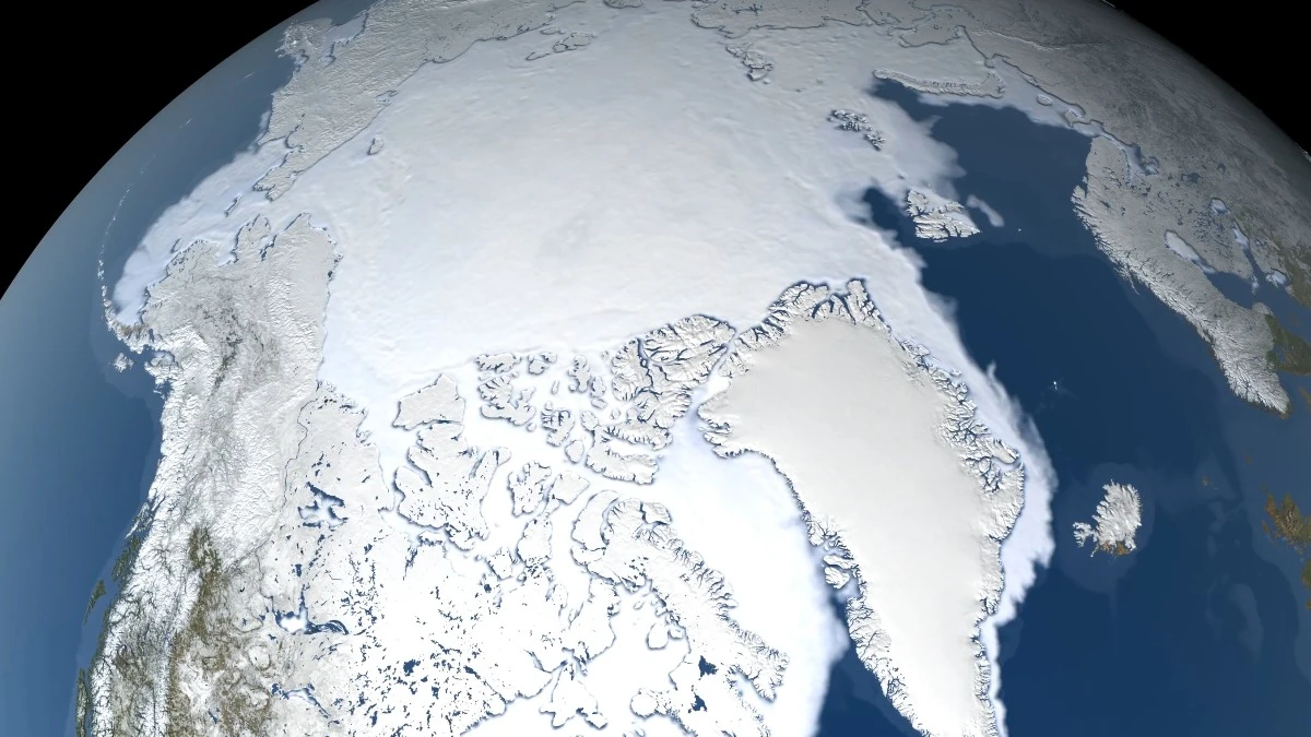
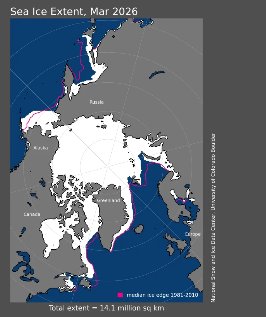
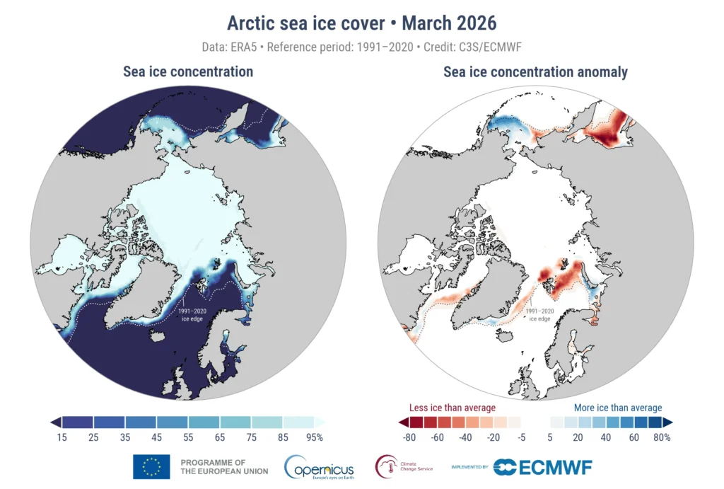
Arctic sea ice extent - March 2026. Credit: NASA
NASA and NSIDC said Arctic sea ice likely reached its winter maximum on March 15, at 14.29 million km² (5.52 million mi²), close to the 2025 maximum of 14.31 million km² (5.53 million mi²). The two years are considered statistically tied in the U.S. dataset.
Japan’s National Institute of Polar Research (NIPR) and the Japan Aerospace Exploration Agency (JAXA) reported a lower maximum of 13.76 million km² (5.31 million mi²) on March 13, based on finalized five-day averaged satellite data. Their dataset places 2026 slightly below 2025, marking a new record low winter extent.
The difference between the two measurements — about 0.53 million km² (204 600 mi²) — reflects differences in processing methods and averaging techniques rather than disagreement about overall conditions. Both datasets show that Arctic winter sea-ice extent remained exceptionally low during the 2026 maximum period.
NASA reported the 2026 maximum was about 1.3 million km² (501 900 mi²) below the 1981–2010 average, extending the long-term decline observed in Arctic sea ice since 1979.
NIPR and JAXA identified limited ice expansion in the Sea of Okhotsk and the Baffin Bay–Labrador Sea region, where above-average temperatures from January to February restricted southward ice development.
Detailed analysis indicates that from January to February 2026, temperatures in the Sea of Okhotsk and in the Baffin Bay – Labrador Sea region remained higher than average, hindering the southward expansion of sea ice.
Furthermore, in the Sea of Okhotsk, easterly to southeasterly winds prevailed from mid-February to mid-March, and temperatures were higher than those during the same period in 2025. As a result, the sea ice extent in the Sea of Okhotsk began to decrease after February 19, which served as a major factor limiting the overall expansion of Arctic sea ice
Observations from the ICESat-2 satellite showed thinner ice across much of the Arctic in 2026, particularly in the Barents Sea northeast of Greenland. The reduced formation of new ice in recent years has also limited the buildup of multi-year ice.
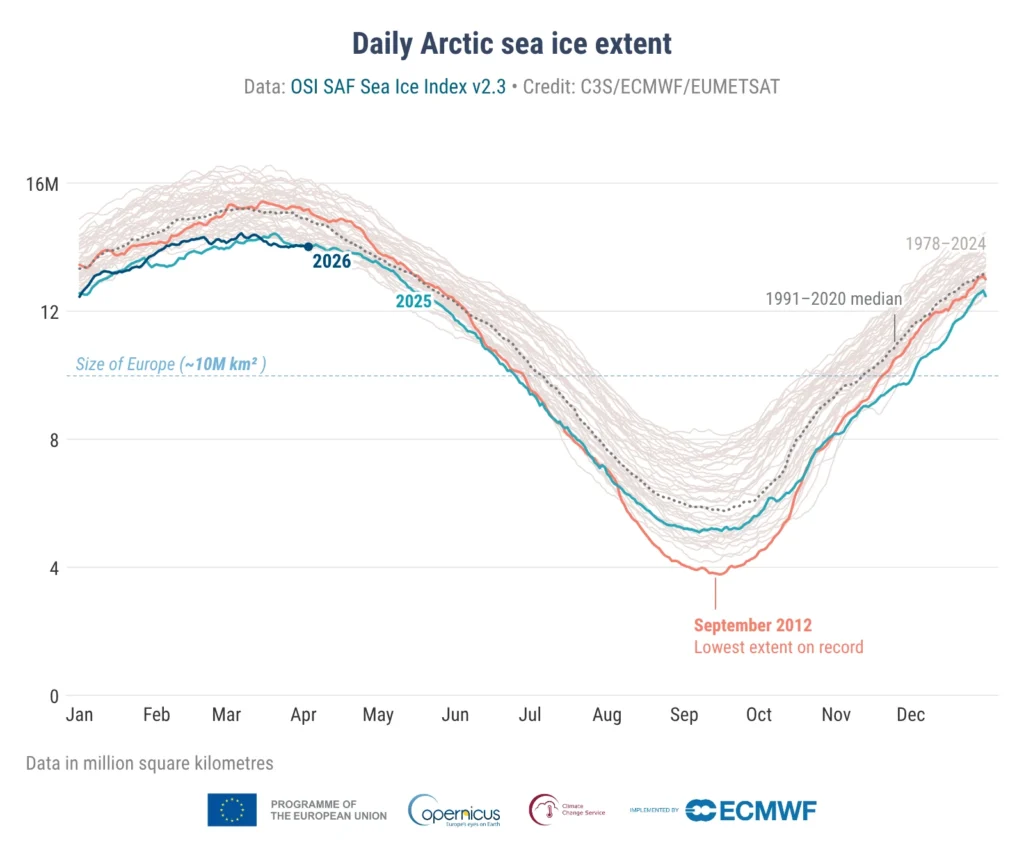
Sea ice extent is defined as the total ocean area with at least 15% ice concentration. Arctic sea ice typically expands through autumn and winter, reaches its annual maximum in March, and declines toward a September minimum.
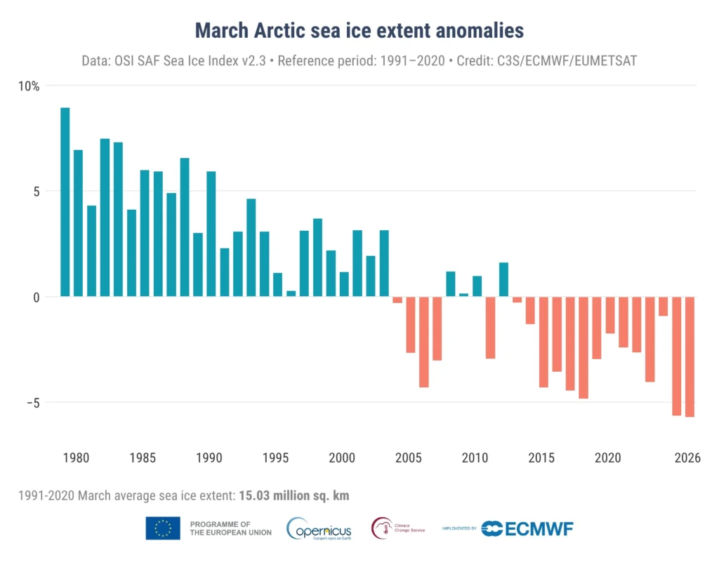
Independent analysis from the Copernicus Climate Change Service found that average Arctic sea-ice extent in March 2026 was 14.2 million km² (5.48 million mi²), about 0.9 million km² (347 500 mi²) or 5.6% below the 1991–2020 average, the lowest March extent in the satellite record.
Since November 2025, Arctic sea ice extent has ranked among the three lowest on record for the corresponding month: second lowest in November, lowest in December, and third lowest in January and February, according to Copernicus.
NIPR and JAXA said their monitoring relies primarily on microwave radiometers, including AMSR2 aboard the GCOM-W “SHIZUKU” satellite, with AMSR3 data expected from the GOSAT-GW “IBUKI GW” mission. NSIDC also uses AMSR2 for real-time monitoring alongside historical satellite records dating back to the late 1970s.
References:
1 Arctic Winter Sea Ice Ties Record Low, NASA, NSIDC Scientists Find – NASA – March 26, 2026
2 Arctic winter sea-ice extent fails to expand and sets a new record low in 2026 – ROIS – May 1, 2026
3 Arctic Winter Sea-Ice Extent Fails to Expand and Sets a New Record Low in 2026 – NiPR – April 30, 2026
I'm a dedicated researcher, journalist, and editor at The Watchers. With over 20 years of experience in the media industry, I specialize in hard science news, focusing on extreme weather, seismic and volcanic activity, space weather, and astronomy, including near-Earth objects and planetary defense strategies. You can reach me at teo /at/ watchers.news.
Commenting rules and guidelines
We value the thoughts and opinions of our readers and welcome healthy discussions on our website. In order to maintain a respectful and positive community, we ask that all commenters follow these rules.