
Lake-effect snow turns open water into winter’s most focused storms
Lake-effect snow occurs when cold Arctic air flows over unfrozen lake water, triggering intense, localized snowfall as moisture rises and forms narrow but powerful snow bands downwind. The phenomenon is common across the Great Lakes region and parts of northern Japan.
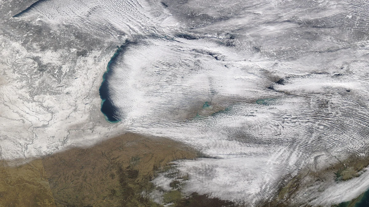
A cold northwesterly to westerly wind over all the Great Lakes created the lake-effect snowfall of January 10, 2022. Credit: NASA/Aqua MODIS
Lake-effect snow starts when very cold, dry air moves across an unfrozen lake that is several degrees warmer. The difference in temperature between the lake surface and the air above creates strong instability. When the air at about 1 500 m (4 900 feet) is at least 13°C (55°F) colder than the lake surface, convection begins. Warm, moist air rises, cools, and condenses to form dense snow clouds.
As the rising air cools, water vapor changes into ice crystals that grow and fall as snow. Within minutes, the clouds can build several kilometers high, releasing continuous snowfall along a narrow line downwind. The process is self-sustaining as long as cold air keeps flowing across the warm water.
The open lake supplies both energy and moisture. Lakes that stay ice-free late in the season, such as Erie and Ontario, can fuel snow events well into winter. Once ice forms, the heat and moisture exchange stops, and the snowbands quickly weaken.
Lake-effect snow functions like a frozen thunderstorm. The same mechanism that lifts warm air in summer storms drives vertical motion here, producing snow instead of rain.
This setup is most effective in late autumn and early winter when Arctic air masses sweep over lakes still holding summer warmth. That contrast is strongest in November and December, the peak months for Great Lakes snow outbreaks.
Wind alignment and the anatomy of snowbands
Wind direction decides where the snow will fall. When wind blows along a lake’s long axis, it travels a greater distance, called the fetch, collecting more heat and moisture. The result is a single, intense snowband that can remain nearly stationary for hours, unloading heavy snow over a narrow corridor.
If the wind crosses the lake diagonally, the fetch is shorter, and several smaller bands appear instead. Motorists can experience clear weather, then a total whiteout, within seconds as they pass through alternating bands.
Within the strongest snowbands, accumulation rates often reach 5–8 cm per hour (2–3 in per hour) and occasionally exceed that during convective bursts. Towns only a few kilometers apart can see vastly different totals, one buried under drifts while the next remains nearly clear.
Vertical wind shear, meaning a change in wind direction or speed with height, controls band strength. Weak shear allows plumes to rise straight upward and stay aligned. Strong shear tilts the clouds and disrupts formation, shortening the event.
These snowbands can extend more than 200 km (124 miles) downwind but are usually only 5–10 km (3–6 miles) wide. Their narrow width is the main reason lake-effect snow is difficult to forecast and highly localized.
The shoreline boost and the role of terrain
When moist air moves from water to land, surface friction slows it down. The slowdown forces air to converge and rise, intensifying snowfall along the first few kilometers inland. This is why the heaviest snow typically falls just beyond the shoreline rather than directly on it.
Hills and elevated plateaus strengthen this effect. They lift air even higher, increasing snowfall totals through orographic lift. The Tug Hill Plateau east of Lake Ontario often receives more than 250 cm (100 inches) of snow each winter for this reason.
Communities in these snowbelts adapt by designing roofs to carry heavy snow, maintaining dense networks of snowplows, and planning emergency responses for rapid accumulation.
Urban areas such as Grand Rapids, Cleveland, and Buffalo experience intense but brief bursts when wind aligns perfectly with a lake. These squalls can drop several centimeters of snow in under an hour, causing sudden road closures and flight delays.
Even a small shift in wind, just 2°, can move the snowband away and end the event abruptly. That volatility defines lake-effect snow and makes each outbreak unique.
Where it hits hardest and why
The Great Lakes of North America, Superior, Michigan, Huron, Erie, and Ontario, store immense heat during summer. When Arctic air flows south, each lake releases that heat and moisture, spawning its own snowstorm.
In November 2022, a massive event along Lake Erie buried western New York. Towns south of Buffalo received between 127–203 cm (50–80 inches) of snow within two days. Orchard Park measured 200 cm (77 inches), while Buffalo–Niagara Airport, only 15 km (9 miles) away, recorded 93 cm (36.6 inches). The sharp contrast showed how small changes in wind direction decide where the heaviest snow falls.
Similar processes occur elsewhere. Along Japan’s Sea of Japan coast, cold Siberian air crosses warm water, producing multi-day “sea-effect” snowfalls in Niigata and Hokuriku. In Utah, the Great Salt Lake generates smaller but powerful snowbands when northwesterly winds pass over its surface.
Each region has adapted to these patterns. Japanese cities use heated streets and covered walkways to manage continuous snow. In the United States, forecasting offices monitor lake temperature, wind, and ice coverage daily through winter to warn communities of new outbreaks.
Studying these events helps scientists understand how small-scale convection and moisture exchange work. Insights from lake-effect research improve forecasting for other weather systems worldwide.
Why forecasting lake-effect snow is so difficult
Forecasting lake-effect snow challenges even the best numerical models. The snowbands are narrow, and small errors in wind direction or temperature can shift them tens of kilometers. A 2° wind change can move the impact zone from one city to another.
To predict these shifts, meteorologists need accurate data on lake temperature, ice cover, and vertical temperature profiles. These conditions vary rapidly, and there are few instruments over the open lakes to provide real-time updates.
Radar and satellites have improved coverage, but cloud layers often block infrared sensors used to measure surface temperature. Strong winds can also distort readings by creating large waves.
Even advanced high-resolution models struggle with precision. They can simulate snowband formation but not always its exact position or intensity. As a result, forecasters emphasize impact-based warnings—visibility drops, road closures, and timing, rather than absolute snowfall totals.
Modern radar systems, especially dual-polarization radars, now help distinguish lake-effect snow from larger storm systems. These tools give scientists real-time insight into snowband shape and motion, reducing surprises for communities downwind.
The invisible structure of a snowband
In a typical setup, frigid air passes over warmer lake water. As it moves, the lowest layer of air absorbs heat and moisture, becomes lighter, and begins to rise. The rising air cools, clouds form, and snow crystals develop within them. The flakes fall while the air continues drifting toward land.
When this air reaches the shoreline, it slows due to friction, forcing an extra upward push that produces the heaviest snowfall just inland. Beyond this zone, the air mass loses its moisture, and the snow quickly tapers off.
This continuous cycle acts like a conveyor belt of moisture and snow that maintains a narrow, intense snowband for hours. The process ends only when the lake freezes or the cold air mass moves away.
Why this phenomenon matters
Lake-effect snow shapes the climate and economy of regions near large lakes. It replenishes freshwater, supports ecosystems adapted to deep snowpack, and drives seasonal tourism in winter sports.
It also brings serious challenges for transportation and energy infrastructure. Roads, airports, and power lines must be built to handle sudden heavy snow loads. Municipal budgets depend on accurate forecasting for plowing and maintenance.
For scientists, these events are invaluable laboratories. Their confined scale and clear dependence on surface conditions make them perfect for testing atmospheric models and studying heat and moisture exchanges.
Understanding lake-effect snow helps communities prepare for its risks, adapt to its variability, and anticipate how climate change may alter it in the decades ahead. It also reveals how local processes connect to global climate dynamics.
References:
1 Lake Effect Snow – NASA – Accessed December 10, 2025
2 What is a Lake Effect Snow? – NWS – Accessed December 10, 2025

I’m a science journalist and researcher at The Watchers, contributing to the Epicenter edition, where I cover peer-reviewed scientific research and emerging discoveries across Earth and space sciences. With a background in astronomy and a passion for environmental science, I’ve worked in shark and coral conservation in Fiji, conducting reef and shark-behavior research, contributing to mangrove restoration, and earning PADI Open Water and Coral Reef Certifications. I bring a blend of scientific rigor and storytelling to illuminate the discoveries shaping our planet and beyond.
Commenting rules and guidelines
We value the thoughts and opinions of our readers and welcome healthy discussions on our website. In order to maintain a respectful and positive community, we ask that all commenters follow these rules.