
Bronze Age proto-city Semiyarka reshapes our understanding of steppe urbanism
Archaeologists have identified a 140 ha (346 acres) Bronze Age settlement at Semiyarka in Abai Oblast, Kazakhstan, revealing one of the largest known urban sites of the Late Bronze Age on the Eurasian steppe.
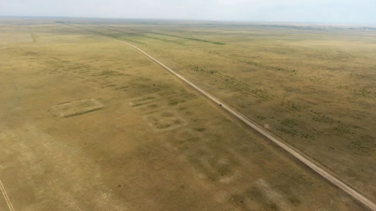
A drone photograph of the archaeological site of Semiyarka, taken in July 2018. Credit: Peter J. Brown
Semiyarka is located on a high promontory in the Beskaragay district of Abai Oblast and rises above a narrow section of the Irtysh River valley. Its elevated position created a vantage point over a major movement corridor that connected the Altai Mountains with the interior of the Eurasian grasslands.
The settlement spans approximately 140 ha (346 acres), a size that places it among the largest known Late Bronze Age sites in northern Kazakhstan. Earlier assessments suggested only 40 ha (99 acres), but geophysical data and systematic survey expanded the known boundaries, redefining the scale of Semiyarka’s urban footprint.
The surrounding landscape contains seven steep ravines, a natural feature that earned the name City of Seven Ravines. These valleys provide a defensive topography and demonstrate why the site commanded strategic control over the surrounding plain.
Historical Corona satellite photographs and modern drone imagery show long rectilinear lines extending for more than 1 km (0.62 miles). These features reveal early structural planning that distinguishes Semiyarka from smaller or more dispersed Bronze Age habitations.
The size, topography, and visibility of its architectural features make Semiyarka a major discovery for understanding how large, organised Bronze Age communities emerged across the Eurasian steppe.
Discovery of an organised and planned architectural landscape
Semiyarka’s architecture is defined by parallel rectilinear earthworks rising around 1 m (3.3 feet) above the present ground surface. These earthworks form two extensive lines of domestic compounds, each containing internal divisions that suggest multi-room structures.
Geophysical prospection by teams from Durham University and Toraighyrov University identified subsurface mudbrick walls beneath the earthworks. These repeated wall patterns indicate standardised construction across the settlement rather than sporadic or loosely planned development.
A large, centrally positioned building lies behind the point where the two architectural rows meet. This structure aligns almost exactly east to west and occupies roughly double the area of nearby domestic units, indicating a possible communal, ritual or administrative role.
The deliberate placement and repeating form of the earthworks contrast with the small camps typically associated with mobile Bronze Age groups. The evidence points to permanent construction and organisation consistent with early urban planning.
Comparisons with other regional sites indicate Semiyarka’s uniqueness. Čiča, one of the largest comparable settlements, covers only around 30 ha (74 acres) and lacks Semiyarka’s monumental central building. Semiyarka’s layout represents a distinct form of early planned settlement in the northern Kazakh steppe.
Evidence for industrial-scale tin bronze production
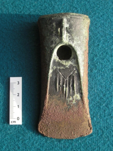
Surface collections and targeted sampling recovered ores, slag, broken crucibles, and completed bronze artefacts, demonstrating that Semiyarka served as a major Bronze Age metallurgical center. The industrial activity appears concentrated in the southeastern section of the settlement.
Thirty-five metal samples were analysed. Copper carbonates such as malachite and azurite were present, alongside tin bronze artefacts alloyed with up to 12% tin. These compositions show that metalworkers at Semiyarka practiced controlled alloying using co-smelting and cementation techniques.
No evidence was found for arsenical, leaded, or antimonial bronzes. This absence suggests a specific technological preference for tin bronze rather than more variable alloying traditions.
Geochemical comparisons link many of the ores to deposits in the Altai Mountains, about 300 km (186 miles) to the east. This sourcing shows that Semiyarka was part of wide-reaching Bronze Age trade networks that moved ore across significant distances.
Other Bronze Age metallurgical centers in the region tend to be located near mountain mines. Semiyarka stands out as the first large steppe settlement with on-site tin bronze production at an urban scale, indicating a high degree of specialisation and organisation.
Mapping artefacts and understanding material distribution
Surface collection used 10 m² sampling units spaced every 50 m (164 feet). This systematic approach allowed archaeologists to measure artefact distribution across a large and varied landscape despite disturbances caused by modern land use such as roadworks, water management, and tree planting.
Ceramic artefacts extended farther east than the primary architectural remains. This wider scatter suggests that activity zones beyond the main earthworks may have supported seasonal or low-intensity habitation.
Finished metal artefacts were concentrated in the western half of the settlement, while metallurgical waste was clustered in the southeast. These patterns indicate spatial separation between areas of production and areas of artefact use or deposition.
Boundary identification relied on detecting rows of sampling units where artefacts disappeared. This method confirmed the approximately 140 ha (346 acres) extent of the settlement and supported the classification of Semiyarka as a proto-urban center.
The ceramic distribution shows strong representation from the Alekseevka Sargary culture, with additional pieces linked to the Cherkaskul tradition. These patterns reflect significant cultural interaction across the Irtysh River corridor.
Cultural identity, chronology, and long-distance interaction
At least 114 ceramic vessels were documented during surface collections. Around 85% of the vessels represent the Alekseevka Sargary culture, active from about 1500 to 1100 BC across the eastern Eurasian steppe. A smaller set of pottery belongs to the Cherkaskul culture, dated to 1600 to 1250 BC in western Siberia.
The complete absence of Begazy Dandybaev ceramics indicates that the site predates the expansion of this later Bronze Age tradition. Investigators propose that Semiyarka was established around the sixteenth century BC based on ceramic typology and regional parallels.
The mixed cultural assemblage signals consistent interaction along the Irtysh River, which served as a major conduit linking Siberia, the Altai region, and central Kazakhstan. This corridor enabled the movement of people, materials, and technological practices between distant regions.
Burial mounds and small settlements near Semiyarka, including Semiyarka 4 and 5, Altybai, Lesnoe, Nurbai, and Chemaar, offer evidence of a wider inhabited landscape. These smaller communities appear to have been connected to Semiyarka through networks of trade, ritual, and labour.
The combined archaeological evidence indicates that Semiyarka acted as a central place within a dispersed system of settlements that shared technological and cultural traditions during the Late Bronze Age.
A new model for Bronze Age settlement in the Eurasian steppe
Semiyarka demonstrates that Bronze Age steppe communities established permanent settlements with coordinated architectural planning, industrial facilities, and communal or administrative buildings. This contradicts older models portraying these groups as exclusively mobile herders.
The site reveals that large-scale tin bronze production could take place in major inhabited centers rather than small remote workshops near ore sources. This shift in understanding highlights a more complex economic structure among Late Bronze Age populations.
The planned layout, monumental architecture, and functional zoning challenge previous assumptions that early urban development occurred only in the major riverine centers of Southwest Asia or the Indus Valley. Semiyarka provides evidence for an independent pathway toward urbanism on the Eurasian steppe.
Semiyarka’s position along a strategic river passage underscores its importance in long-distance exchange systems. The integration of ore movement, craft production, and settlement organisation offers a rare view of how Bronze Age communities structured their economies.
Future work under the DREAM project will refine the chronology, investigate craft production in greater detail, and clarify the social functions of monumental structures at the site. Semiyarka now stands as one of the most significant examples of early organised settlement in the northern Kazakh steppe.
References:
1 “City of seven ravines”: Bronze Age metropolis unearthed in the Eurasian steppe – Antiquity – November 18, 2025

I’m a science journalist and researcher at The Watchers, contributing to the Epicenter edition, where I cover peer-reviewed scientific research and emerging discoveries across Earth and space sciences. With a background in astronomy and a passion for environmental science, I’ve worked in shark and coral conservation in Fiji, conducting reef and shark-behavior research, contributing to mangrove restoration, and earning PADI Open Water and Coral Reef Certifications. I bring a blend of scientific rigor and storytelling to illuminate the discoveries shaping our planet and beyond.
Commenting rules and guidelines
We value the thoughts and opinions of our readers and welcome healthy discussions on our website. In order to maintain a respectful and positive community, we ask that all commenters follow these rules.