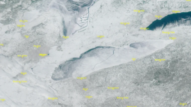
• Major atmospheric river moves into Washington State, triggering widespread and potentially historic riverine flooding

    A major atmospheric river is producing very heavy precipitation across western Washington today into early December 11, 2025, triggering widespread and potentially historic riverine flooding, according to the Center for Western Weather and Water Extremes (CW3E). Forecasts indicate 130–200 mm (5–8 inches) of rain over the central and northern Washington Cascades and 75–130 mm (3–5 inches) over the Olympic Peninsula through 04:00 PST (12:00 UTC) on December 12. CW3E modeling shows 15 river gauges expected to exceed major flood stage and four to surpass record levels within 48 hours.

  • Fatal wave at Tenerife’s Isla Cangrejo natural pool leaves four dead

    A powerful wave struck the Isla Cangrejo natural pool in the coastal area of Los Gigantes, Tenerife, at around midday on December 7, 2025, sweeping swimmers into the ocean. Four tourists died, several others were injured, and one person remains missing. A coastal pre-alert for rough seas was in effect at the time of the incident.

  • Glacial outburst flood in Skaftá River confirmed to originate from Vestari-Skaftár caldera, Iceland

    A glacial outburst flood in Iceland’s Skaftá River, first detected on December 8, 2025, has been confirmed to originate from the Vestari-Skaftár caldera beneath Vatnajökull ice cap. Flow at the Sveinstind station has decreased to just over 120 m³/s, down from 200 m³/s earlier in the week. Conductivity remains high and hydrogen sulfide continues to be detected along the river, but no impacts on major roads have been reported.

  • Multi-model forecasts indicate increased atmospheric river activity and transition from West Coast Ridge to Pacific Ridge in late December

    Subseasonal forecasts by CW3E show strong multi-model agreement on above-normal atmospheric river activity across the U.S. West Coast during mid- to late December, with the strongest signals over Northern California. Forecast regime tools indicate a transition from a West Coast Ridge to a Pacific Ridge during this period, altering temperature and precipitation patterns across the region.

  • Blizzard warnings in effect for parts of West Virginia and western Maryland

    Blizzard warning have been issued with snowfall totals of up to 30 cm (12 inches) being forecast across the high western slopes along with gusts of 80 km/h (50 mph) across multiple mountain counties. The warnings are in effect for parts of West Virginia, western Maryland, and western Virginia from 10:00 EST Wednesday, December 10, 2025 to 10:00 EST Thursday, December 11.