
Tropical Storm Rachel brings flash-flood threat to Southern California and U.S. Southwest
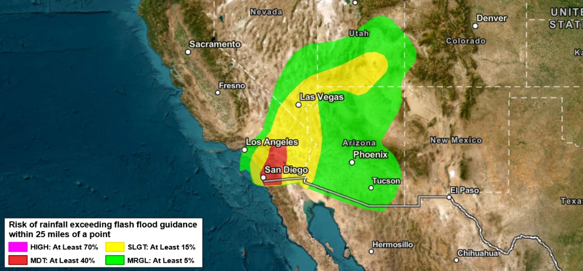
Tropical Storm Rachel strengthened while accelerating northeast over the eastern Pacific at 06:00 UTC on October 10, 2026, and is forecast to approach northern Baja California or Southern California late October 10 or early October 11. Heavy rain, flash and urban flooding, strong winds, dangerous surf and coastal flooding are forecast across parts of the southwestern United States, where the Weather Prediction Center (WPC) has issued Moderate Risk areas for excessive rainfall.

Satellite image of Tropical Storm Rachel at 09:10 UTC on October 10, 2026. Credit: NOAA/GOES-19, RAMMB /CIRA, The Watchers
At 23:00 PDT on October 9 (06:00 UTC on October 10), the center of Tropical Storm Rachel was about 1 080 km (670 miles) south-southwest of San Diego. Maximum sustained winds were 95 km/h (60 mph), the minimum central pressure 990 hPa, and the storm was moving northeast at 19 km/h (12 mph).
The National Hurricane Center (NHC) forecasts a general northeast to north-northeast motion with a significant increase in forward speed. The center is expected to approach northern Baja California or Southern California late Saturday or early Sunday, followed by rapid weakening after the system moves inland on October 11.
A Tropical Storm Warning covers portions of northern Baja California, while a Tropical Storm Watch extends along the Southern California coast from the United States–Mexico border to the San Diego–Orange County line. The National Weather Service (NWS) San Diego office extended the watch to all San Diego County forecast zones and adjacent coastal waters.

WPC upgraded portions of Southern California, northwestern Arizona, southern Nevada and southwestern Utah to a Moderate Risk of excessive rainfall, level 3 of 4, for the 24 hours ending at 05:00 PDT (12:00 UTC) on October 11. A second Moderate Risk area is in place for the following 24 hours as Rachel’s remnant circulation and tropical moisture move northeast from Southern California toward the Great Basin.
The Center for Western Weather and Water Extremes (CW3E) reported that Rachel’s projected track shifted north and west between October 8 and 9, increasing the potential for heavier rainfall in Southern California. About 60% of the global ensemble members examined by CW3E placed Rachel within 150 km (95 miles) of eastern San Diego County.
CW3E said the Tropical Storm Watch was only the second issued for San Diego County, following Hurricane Hilary in 2023.
NHC forecasts Rachel and its associated moisture to produce 25–76 mm (1–3 inches) of rain across portions of the Southwest, with localized totals reaching 127 mm (5 inches).
Within the NWS San Diego forecast area, 13–32 mm (0.5–1.25 inches) is forecast across coastal, valley and desert areas, while mountain totals are expected to reach 25–64 mm (1–2.5 inches). Peak mountain rainfall rates of 13–25 mm per hour (0.5–1 inch per hour) are possible on Sunday.
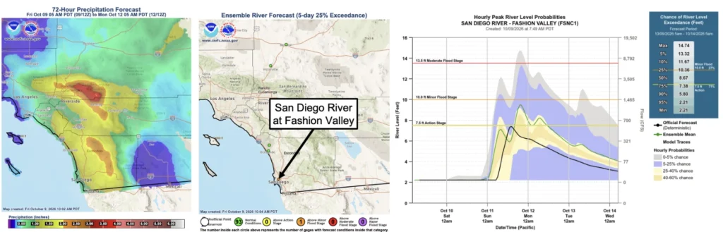
The October 9 CW3E analysis showed substantial model spread over the San Bernardino Mountains. Forecast basin-average totals at Seven Oaks through 17:00 PDT on October 12 (00:00 UTC on October 13) ranged from about 28 mm (1.1 inches) in GFS and GEFS guidance to 48 mm (1.9 inches) in the ECMWF ensemble and 81 mm (3.2 inches) in the deterministic ECMWF forecast.
The California–Nevada River Forecast Center (CNRFC) separately forecast local totals of up to 102 mm (4 inches) over higher terrain in the San Bernardino Mountains by 05:00 PDT (12:00 UTC) on October 12.
At the San Diego River gauge at Fashion Valley, CW3E reported a 71% CNRFC ensemble probability of exceeding action stage and a 27% probability of exceeding minor flood stage. CNRFC defines action stage as 2.29 m (7.5 feet), when low-lying roads near Fashion Valley Mall begin flooding, and minor flood stage as 3.05 m (10 feet).
The official NWS deterministic forecast was lower, with the river expected to crest near 2.26 m (7.4 feet) on Sunday afternoon, just below action stage. CNRFC cautions that river guidance contains significant uncertainty and does not replace official watches, warnings, or statements.
A Flood Watch is in effect from Saturday evening through Sunday evening for all of San Diego County, the Riverside and San Bernardino County mountains, the Coachella Valley, the Apple and Lucerne valleys, and the San Gorgonio Pass area. Flash and urban flooding are possible, particularly where heavier rainbands persist.
NWS forecasts wind gusts of 64–89 km/h (40–55 mph) along desert-facing mountain slopes and in desert areas, with localized gusts near 97 km/h (60 mph) on mountain ridges. Tropical-storm-force winds are possible in parts of San Diego County late Saturday night or Sunday.
Surf along the San Diego County coast is forecast to reach 1.5–2.4 m (5–8 feet) on Sunday, with sets near 2.7 m (9 feet). Morning high tides of 2.1–2.3 m (7–7.5 feet), elevated surf, and onshore winds are expected to produce significant coastal flooding and beach erosion.
A Coastal Flood Warning remains in effect for the Orange and San Diego County coasts through 15:00 PDT on October 11. It is scheduled to be replaced by a Coastal Flood Advisory through 14:00 PDT on October 13.
Another low-pressure system approaching from the northwest may maintain lighter and more scattered showers across coastal and mountain areas on Monday and Tuesday. Drier conditions are forecast to return by Wednesday.
References:
1 CW3E Precipitation Outlook: 9 October 2026 – CW3E – October 9, 2026
2 Tropical Storm Rachel Intermediate Advisory Number 52A – NOAA/NHC – October 10, 2026

Rishav Kothari is Editor-in-Chief of The Watchers, where he runs the newsroom and covers earthquakes, volcanoes, severe weather and space weather.
