
Major M7.6 earthquake damages buildings across Panama, tsunami threat ends
A major M7.6 earthquake struck central Panama at 17:56 UTC (12:56 local time) on October 9, 2026, causing structural damage, injuries, widespread evacuations and disruptions to electricity, transportation and public services. The Pacific Tsunami Warning Center (PTWC) ended the associated tsunami threat at 19:40 UTC, while authorities continued assessing damage and monitoring aftershocks.

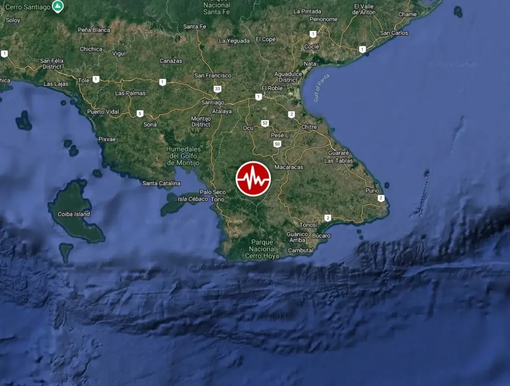
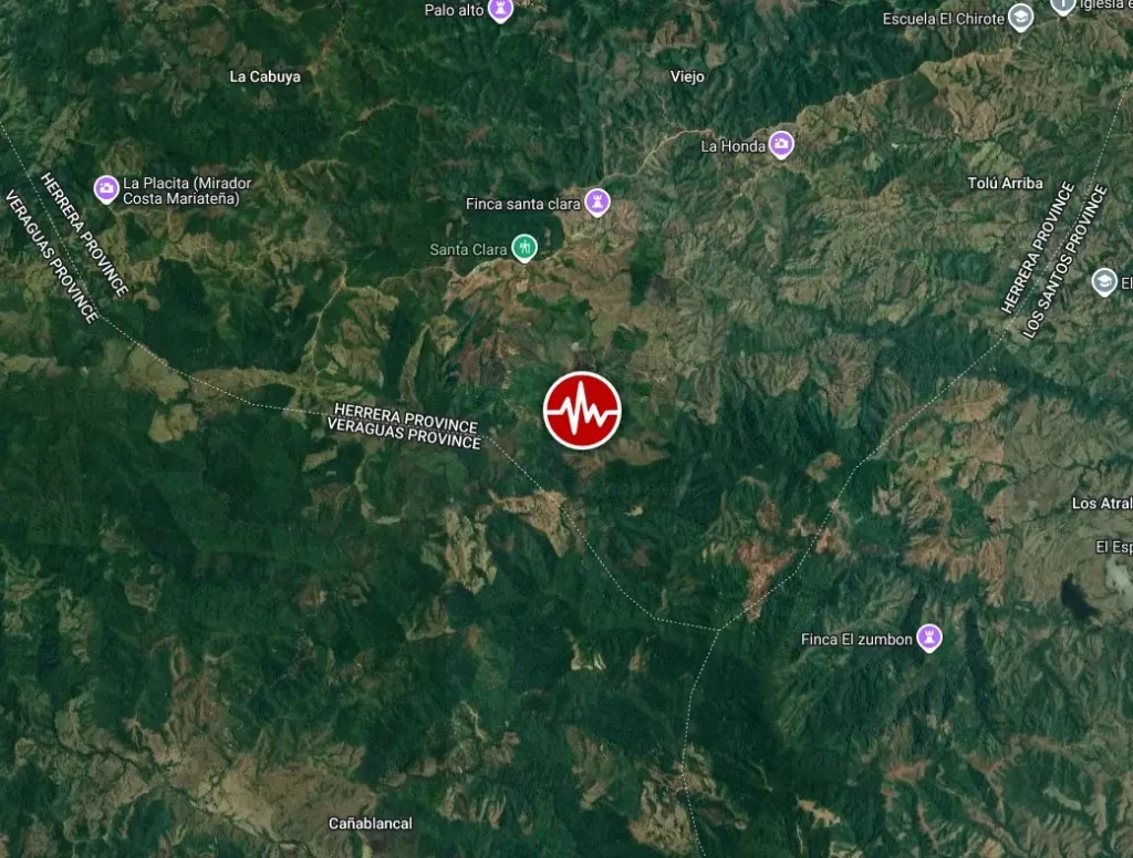
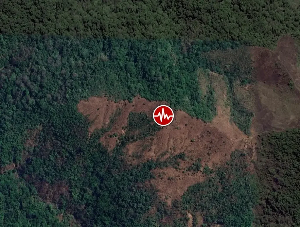
Epicenter of M7.7 earthquake near Pitaloza Arriba, Panama on October 9, 2026. Credit: TW/SAM, Google
The epicenter was located 10.8 km (6.7 miles) WSW of Pitaloza Arriba (population 188), 54.1 km (33.6 miles) SW of Chitré (population 8 969), 55.4 km (34.4 miles) SW of San Juan Bautista (population 11 798), 55.7 km (34.6 miles) SW of Monagrillo (population 10 821), and 61.1 km (37.9 miles) SSE of Santiago de Veraguas (population 45 355), Panama.
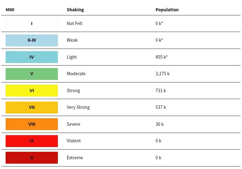
36 000 people are estimated to have felt severe shaking, 538 000 very strong, 842 000 strong, 3 million moderate and 455 000 light.
Based on all available data, hazardous tsunami waves are forecast for some coasts following the M7.6 earthquake in Panama, NWS Pacific Tsunami Warning Center (PTWC) said in a message issued at 18:31 UTC on October 9.
Tsunami waves reaching 1 to 3 m (3.3 to 9.8 feet) above tide level are possible along some coasts of Panama, while waves of 0.3 to 1 m (1 to 3.3 feet) are possible along some coasts of Ecuador.
Waves of less than 0.3 m (1 foot) above tide level are forecast for the coasts of Chile, Colombia, Costa Rica, El Salvador, Guatemala, Honduras, Mexico, Nicaragua and Peru.
The USGS PAGER alert for shaking-related fatalities and economic losses is currently under review.
Overall, the population in this region resides in structures that are a mix of vulnerable and earthquake-resistant construction. The predominant vulnerable building types are unreinforced brick masonry and adobe block construction.
Recent earthquakes in this area have caused secondary hazards such as tsunamis, landslides and liquefaction that might have contributed to losses.
Estimated population exposure to earthquake shaking
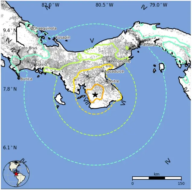
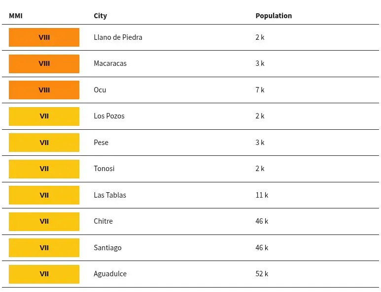
Selected cities exposed
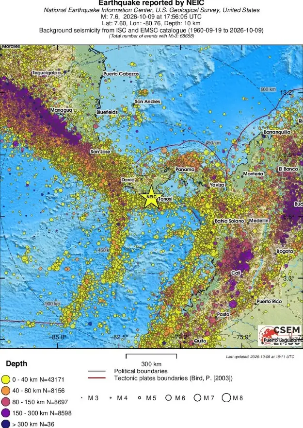
Regional seismicity
Updates
18:51 UTC, October 9
PTWC has updated its tsunami threat forecast following the M7.6 earthquake in Panama.
Tsunami waves reaching 1 to 3 m (3.3 to 9.8 feet) above tide level remain possible along some coasts of Panama.
The forecast for Ecuador has been reduced from 0.3 to 1 m (1 to 3.3 feet) to less than 0.3 m (1 foot). Waves below 0.3 m (1 foot) are also forecast for numerous other Pacific coastal areas, including Colombia, Costa Rica, Nicaragua, Mexico, Peru, Chile and Japan.
21:03 UTC, October 9
PTWC has ended the tsunami threat associated with the M7.6 earthquake that struck central Panama earlier today. In its fourth message, issued at 19:40 UTC, the center confirmed that no tsunami warning, advisory, watch or threat remained in effect.
The USGS has revised the earthquake’s magnitude several times, from an initial M8.0 to M7.6, subsequently M7.7, and currently a reviewed M7.6. The latest reviewed USGS solution places the earthquake at a depth of 10 km (6.2 miles), approximately 10 km (6.2 miles) west-southwest of Pitaloza Arriba in Herrera Province.
Panama’s National Civil Protection Service (SINAPROC) reported structural damage concentrated in the central provinces of Herrera, Veraguas and Los Santos. Significant damage was also documented in Penonomé, Coclé Province, where the bell tower of San Juan Bautista Cathedral collapsed.
Additional damage was reported at the provincial governor’s office and Hotel Dos Continentes in Penonomé. Reuters independently verified footage showing damage to a church and nearby buildings, while local authorities continued assessing residential and public structures.
In Herrera Province, residents of Las Minas reported damaged homes and cracks in residential buildings. Damage was also reported in Chitré and coastal communities of Los Santos Province.
Local news outlet Panamá América reported that part of the tower of the Basílica Menor in Atalaya, Veraguas Province, collapsed. Cracks were also reported in the bell tower of San Atanasio Church in Los Santos.
Additional reports indicated damage to the Santiago–Arenas road near Mariato, where a fractured section of roadway disrupted traffic. Damage was also reported at the Soná fire station, the Horacio Díaz Gómez polyclinic and the Santiago transport terminal. The extent of these reported impacts remains subject to official structural assessments.
Several injuries were reported following the earthquake, according to SINAPROC director Omar Smith. One person was injured by falling debris from a partially collapsed structure in Penonomé.
The earthquake caused widespread disruption to electricity and transportation services. Electricity provider Naturgy reported outages across six provinces, while Tocumen International Airport temporarily suspended flight operations.
Panama City Metro services were also interrupted, and authorities suspended classes nationwide. Numerous commercial buildings, government offices and residential towers were evacuated as a precaution, including in Panama City, where shaking was strongly felt.
The Panama Canal Authority confirmed that vessel transit operations continued normally despite the earthquake. Specialized technical teams were inspecting canal infrastructure to identify possible damage and ensure the continued safety of operations.
Multiple significant aftershocks followed the mainshock, including an M5.5 earthquake at 18:22 UTC, located 3 km (1.9 miles) southwest of Bajo Corral, and an M5.8 earthquake at 18:37 UTC, located approximately 1 km (0.6 miles) south of El Cacao. Both were recorded at depths of 10 km (6.2 miles).
Néstor Luque, director of Panama’s Institute of Geosciences, attributed the earthquake to the Azuero–Soná Fault System, a network of active crustal faults associated with tectonic deformation in the Azuero Peninsula. According to Luque, accumulated stress along the fault system was released during the earthquake.
The earthquake was felt across Panama and in neighboring Costa Rica and Colombia. In Panama City, witnesses reported prolonged shaking that prompted thousands of residents and office workers to leave buildings and gather in open areas.
Panamanian authorities continue to inspect damaged infrastructure, assess affected communities, restore disrupted services and monitor the aftershock sequence. The full extent of the earthquake’s impact remains undetermined at this time.
08:15 UTC, October 10
At least 27 people sustained minor injuries and more than 400 structures were damaged, according to the latest preliminary assessment by SINAPROC. No fatalities or missing persons have been reported.
The National Emergency Operations Center (COEN) reported damage across nine provinces, including 142 houses, four residential buildings, 188 educational facilities, 20 healthcare facilities, 26 government buildings, 13 churches, seven hotels and nine bridges. Multiple road sections and water-treatment facilities were also affected.
In Coclé Province, authorities reported 50 damaged homes, two hotels with significant damage, two hospitals, two schools, two churches and four government buildings. At least 17 people sustained minor injuries, while eight families were relocated to a temporary shelter.
The provincial capital, Penonomé, was among the most severely affected locations. One of the two towers of San Juan Bautista Cathedral collapsed, while an entire side of the Coclé provincial government building collapsed, exposing its interior offices. The remaining section sustained structural cracks.
In Los Santos Province, authorities documented damage to 14 homes, five hotels, four hospitals, 22 schools, two churches and 18 government buildings. Six people sustained minor injuries.
Five communities in Los Santos remained isolated due to damaged bridges, roads and landslides. Approximately 300 residents of Isla Cañas were evacuated to higher ground in the community of Cañas following reports of rising sea levels.
In Veraguas Province, preliminary assessments identified 18 damaged homes, eight healthcare facilities, 35 schools, three churches and three government buildings. Three bridges and three road sections were also damaged.
The communities of Arena, Cacao and Quebro remained inaccessible due to road collapses.
In Herrera Province, 30 homes sustained partial damage and two were destroyed. Authorities also reported damage to two hospitals, 48 schools and three churches, along with a landslide affecting the Chitré–Las Minas road. One community remained isolated.
Damage was also reported in Chiriquí Province, where 16 homes and 20 educational facilities were affected. A water tank collapsed, and cracks were identified at a water-treatment facility.
Panamanian authorities reported that nearly all the country’s drinking-water treatment plants experienced some structural effects from the earthquake. The Federico Guardia Conte treatment plant, which supplies Panama City, was operating at approximately 20% of its normal capacity in the initial government assessment.
The aftershock sequence continued overnight, with the USGS recording an M6.0 earthquake at 04:14 UTC on October 10, approximately 7 km (4.3 miles) north of La Tronosa, at a depth of 10 km (6.2 miles).
Additional significant events included an M5.4 earthquake at 23:12 UTC on October 9, approximately 9 km (5.6 miles) south-southeast of Los Asientos, and an M5.1 earthquake at 02:26 UTC on October 10, approximately 1 km (0.6 miles) north-northeast of Tonosí. An M4.9 event was also recorded near Cañas at 06:18 UTC.
The sequence included an earlier M6.6 earthquake at 20:25 UTC on October 9, approximately 14 km (8.7 miles) west of Río Grande, at a depth of 10 km (6.2 miles).
Panama’s Institute of Geosciences reported more than 100 aftershocks following the mainshock, with seismic activity continuing across the Azuero region.
The USGS preferred reviewed solution now places the mainshock at M7.7, with an epicenter approximately 12 km (7.5 miles) west-southwest of Pitaloza Arriba and a depth of 12.6 km (7.8 miles).
Emergency teams continue assessing damaged buildings, roads, bridges and essential infrastructure, while authorities work to restore access to isolated communities and provide assistance to displaced residents. The national damage assessment remains preliminary and is expected to change as inspections continue.
References:
1 M7.7 earthquake Panama – USGS – October 9, 2026
2 M7.9 earthquake Panama – EMSC – October 9, 2026
3 M7.6 earthquake Panama – NWS/PTWC – October 9, 2026

Teo Blašković founded The Watchers in 2011 and edited it until 2026, covering seismic and volcanic activity, extreme weather, space weather and near-Earth objects. Articles on this page are his archive.
