
Tornado threat forecast as Hurricane Isaias strengthens ahead of northern Gulf Coast landfall, United States
The Storm Prediction Center (SPC) issued a Slight Risk of severe thunderstorms for parts of the Florida Panhandle, southeastern Alabama, and southwestern Georgia on October 9, 2026, as rainbands from Hurricane Isaias were forecast to bring a tornado threat from the afternoon into the overnight hours. At 09:00 UTC, the National Hurricane Center (NHC) said Isaias had strengthened to 175 km/h (110 mph), with a minimum central pressure of 963 hPa, ahead of an expected northern Gulf Coast landfall Friday night or early Saturday.
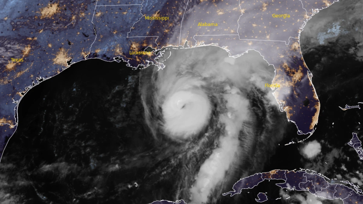
Satellite image of Hurricane Isaias at 11:00 UTC on October 9, 2026. Credit: NOAA/GOES-19, RAMMB/CIRA, The Watchers
At 09:00 UTC (04:00 CDT) on October 9, the center of Isaias was located approximately 590 km (370 miles) north-northeast of Progreso, Mexico, and 320 km (200 miles) south-southeast of the mouth of the Mississippi River.
The hurricane was moving north-northeast at 24 km/h (15 mph), with maximum sustained winds of 175 km/h (110 mph). Hurricane-force winds extended up to 45 km (30 miles) from the center, while tropical-storm-force winds extended up to 295 km (185 miles).
NHC said Isaias was likely to become a major hurricane during the morning before increasing wind shear caused some weakening near landfall. The cyclone was nevertheless expected to reach the northern Gulf Coast as a dangerous hurricane Friday night, October 9, or early Saturday, October 10.

NHC said preparations in warning areas should be completed immediately because conditions were expected to deteriorate quickly on October 9.
A Hurricane Warning was in effect from Ocean Springs, Mississippi, to the Bay/Gulf County line in Florida, while a Storm Surge Warning extended from the mouth of the Mississippi River to the Suwannee River.
Hurricane conditions were expected within the Hurricane Warning area Friday night into early Saturday, with tropical-storm conditions beginning earlier.
NHC forecast peak storm-surge inundation of 1.5–2.1 m (5–7 feet) above normally dry ground from Dauphin Island, Alabama, to Indian Pass, Florida, if the peak surge occurred at high tide.
Inundation of 1.2–1.8 m (4–6 feet) was forecast from Indian Pass to the Steinhatchee River. Inundation of 0.9–1.5 m (3–5 feet) was forecast from the mouth of the Mississippi River to Dauphin Island, within Mobile Bay, and from the Steinhatchee River to the Suwannee River.
Large and dangerous waves were expected in coastal areas exposed to onshore winds.
Isaias was forecast to produce 100–200 mm (4–8 inches) of rain through the weekend across southern Alabama, the Florida Panhandle and Big Bend, and southwestern Georgia. Localized totals up to 380 mm (15 inches) were possible, particularly where rainbands persisted over the Florida Panhandle and Big Bend.
NHC said flash and urban flooding were likely, with considerable impacts possible from southern Alabama through the Florida Panhandle into southwestern Georgia. River flooding was also expected, with some significant flooding possible.

SPC issued its Day 1 Convective Outlook at 05:37 UTC on October 9, valid from 12:00 UTC on October 9 to 12:00 UTC on October 10. Thunderstorms within Isaias’ rainbands were forecast to move inland across the Florida Panhandle during the afternoon, with the tornado threat continuing into the night as the bands moved into southeastern Alabama and southwestern Georgia.
The Day 2 outlook maintained a Slight Risk from the northeastern Gulf Coast into the Savannah River Valley. A few tornadoes were possible from the Florida Panhandle through parts of Georgia and the Carolinas from Saturday into Saturday night.
Florida expanded its state of emergency from 25 to 27 counties under Executive Order 26-211 and activated preparations across transportation, law enforcement, corrections, emergency management and human services.
The Florida Department of Transportation said nearly 1 000 generators, 100 pumps and 260 pieces of heavy equipment had been prepared and staged for deployment. State officials also said two urban search-and-rescue teams from South Florida were being staged in Tallahassee.
Florida corrections authorities evacuated inmates from the Pensacola Work Release Center, Panama City Work Release Center, Okaloosa Work Camp and Century Work Camp.
The Florida Fish and Wildlife Conservation Commission said its officers were ready to deploy with 10 airboats, 18 shallow-draft boats, nine ATVs and side-by-sides, six larger platform vessels, 75 four-wheel-drive vehicles and four swamp buggies.
Florida transportation officials staged bridge inspectors for post-storm assessments and coordinated with seaports, airports, railroads, transit systems and spaceports.
Other state agencies prepared road-clearing and emergency-response resources, identified first-responder refueling locations along the Interstate 10 corridor, and placed aviation and reconnaissance assets on standby for post-landfall damage assessments.
References:
1 Hurricane Isaias Advisory Number 11 – NOAA/NHC – October 9, 2026
2 Hurricane Isaias Discussion Number 11 – NOAA/NHC – October 9, 2026
3 Day 1 Convective Outlook – NOAA/SPC – October 9, 2026

I am an Assistant Editor and Severe Weather & Science Journalist at The Watchers, specializing in real-time severe weather coverage, geophysical event reporting, and research-driven scientific analysis. You can reach me at rishav(at)watchers(.)news.

Commenting rules and guidelines
We value the thoughts and opinions of our readers and welcome healthy discussions on our website. In order to maintain a respectful and positive community, we ask that all commenters follow these rules.