
Dangerous surf to impact east-facing shores as Tropical Depression Fausto weakens north of Hawaii
Former hurricane Fausto weakened to a tropical depression as it tracked north of the Hawaiian Islands late Tuesday, July 28, 2026. Dangerous surf generated by it is building across exposed east-facing shores of the Hawaiian Islands and is expected to remain hazardous through Wednesday, July 29, as the weakening cyclone passes north of the state. Forecasts indicate the strongest winds and heaviest rainfall will stay north of the islands. There are no coastal watches or warnings currently in effect.
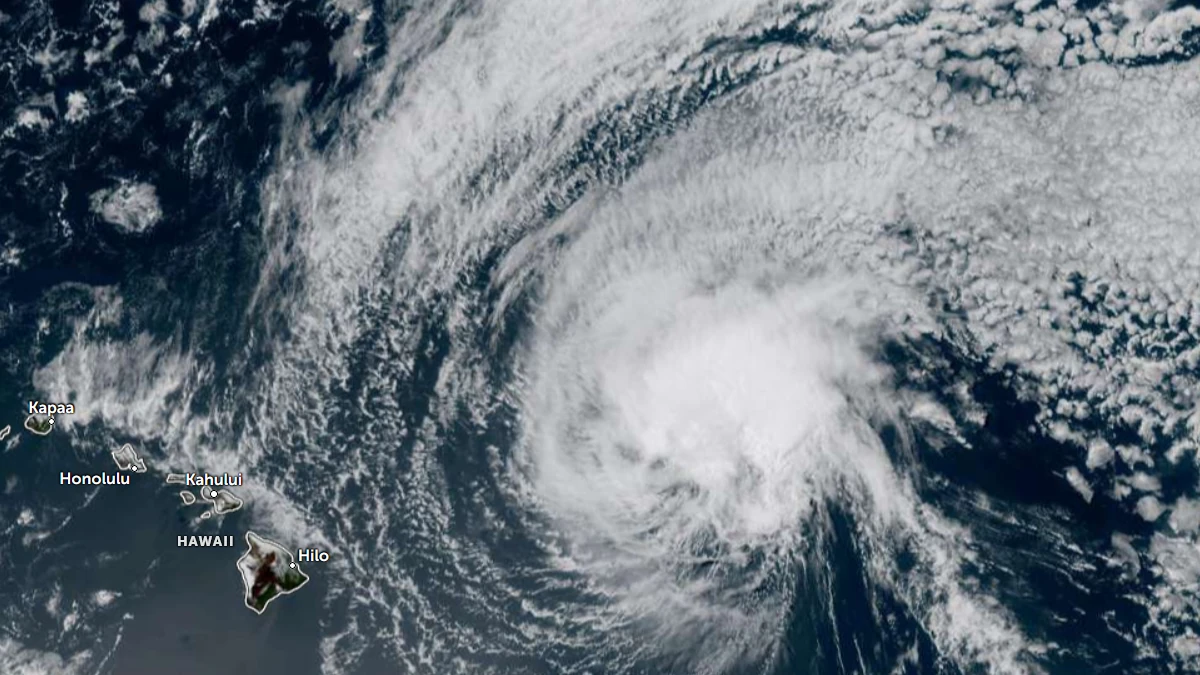
Satellite image of Tropical Storm Fausto at 00:00 UTC on July 29, 2026. Credit: NOAA/GOES-19, Zoom Earth, The Watchers
Fausto weakened into a tropical depression late Tuesday night, July 28, while continuing to move west-northwest north of the Hawaiian Islands.
Although the strongest winds and heaviest rainfall are forecast to remain north of the state, the Central Pacific Hurricane Center (CPHC) warned that dangerous surf and strong currents generated by the system will continue to affect exposed east-facing shores across the Hawaiian Islands through Wednesday, July 29.
Tropical Depression Fausto was located approximately 405 km (250 miles) north of Hilo and 415 km (255 miles) east-northeast of Honolulu.
The system had 1-minute sustained winds of 55 km/h (35 mph) and was moving west-northwest at 19 km/h (12 mph). The estimated minimum central pressure was 1 008 hPa.

Fausto is forecast to continue tracking west-northwest and pass north of the Hawaiian Islands through late Wednesday while steadily weakening. Forecast guidance indicates the system will become a post-tropical remnant low on Wednesday.
No coastal watches or warnings were in effect at the time of the advisory. The strongest winds and heaviest rainfall associated with the depression are expected to remain north of the islands.

Hazardous surf produced by Fausto is building westward across the Hawaiian Islands along exposed east-facing shores and is expected to remain dangerous through Wednesday.
Large breaking waves and strong currents are forecast to create hazardous conditions for beachgoers, swimmers, and mariners using exposed coastal areas.
References:
1 Tropical Depression Fausto Advisory Number 42 – CPHC/NHC – July 28, 2026

I am an Assistant Editor and Severe Weather & Science Journalist at The Watchers, specializing in real-time severe weather coverage, geophysical event reporting, and research-driven scientific analysis. You can reach me at rishav(at)watchers(.)news.

Commenting rules and guidelines
We value the thoughts and opinions of our readers and welcome healthy discussions on our website. In order to maintain a respectful and positive community, we ask that all commenters follow these rules.