
Heat Advisory issued for Bay Area, California
A Heat Advisory has been issued for multiple regions in California, including the North Bay, East Bay, South Bay, Santa Cruz Mountains, and Central Coast, for Friday, May 30, 2025, due to forecast temperatures reaching up to 41°C (105°F).

Maximum temperature forecast map for Friday, May 30, 2025. Credit: NWS
An upper-level low over southern California is forecast to move southwestward over northwestern Mexico by Friday evening, while a ridge of high pressure develops over California and into the Great Basin on Friday morning. The upper-level ridging will allow temperatures to rise considerably, prompting Heat Advisories and Excessive Heat Warnings over parts of California.
A Heat Advisory has been issued for the North Bay, East Bay, South Bay, Santa Cruz mountains, and Central Coast, for Friday, May 30.
The advisory was issued due to ‘Moderate’ to isolated ‘Major’ heat risk, with high temperatures being forecast to reach 35 to 41°C (95 to 105°F).
The heat risk is expected to be most severe in the North Bay interior mountains, East Bay Hills, interior Central Coast, and Santa Cruz Mountains.
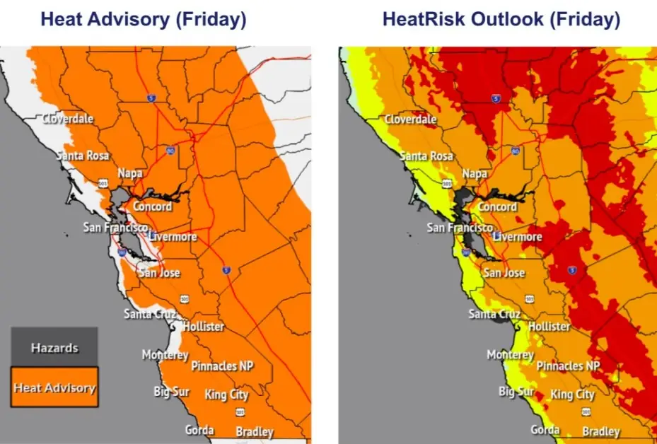
Towns such as Boulder Creek and Ben Lomond are expected to reach temperatures of 36.5 to 37 °C (upper 90s °F). Vulnerable groups, including outdoor workers, older adults, unhoused residents, pets, and livestock, face an increased risk of heat-related illness, particularly without proper cooling or hydration.
Elevated fire danger is also expected from Friday into Saturday, May 31. Daytime humidity may drop to 15 to 22 percent. While winds are not forecast to be extreme, the combination of dry air, dry grasses, and recent vegetation growth could increase the risk of fire.

Rishav Kothari is Editor-in-Chief of The Watchers, where he runs the newsroom and covers earthquakes, volcanoes, severe weather and space weather.
Earlier reporting
Nothing on Watchers was published in the last 24 hours. These are older articles.
- Weipa hits 41 straight days above 36°C as severe heatwave grips Far North Queensland through November 19
- On October 22, 2017, a single flash of lightning stretched 515 miles from eastern Texas to near Kansas City, a distance that takes eight hours to drive, and nobody realized how far it had gone until scientists went back through the satellite data years later Epicenter
- CPC posts a slight risk of heavy rain from the Gulf Coast to the Northeast urban corridor November 25-29, and a moderate risk of West Coast wind and Sierra snow on November 25
- Florida's east coast faces a moderate flash flood risk Wednesday through Friday, with 4 to 8 inches of rain forecast and the St. Johns River near Cocoa already in major flood at 17.13 feet
