
Significant winter storm targets Northern Plains and Upper Midwest, US
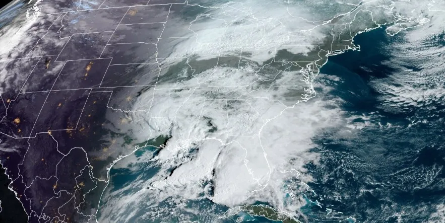
Image credit: NOAA/GOES-East, RAMMB/CIRA, The Watchers. Acquired at 13:30 UTC on March 22, 2024
A significant winter storm is expected to produce widespread heavy snow and hazardous travel conditions across portions of the Northern Plains and Upper Midwest this weekend and into early next week.
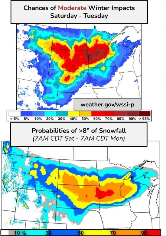
Confidence continues to increase in a large storm system that will produce an area of heavy snow over the Northern Plains and into the Upper Midwest, along with some areas of mixed precipitation this weekend into early next week, the NWS Weather Prediction Center (WPC) warned on March 22, 2024.
Heavy snow is forecast to overspread eastern Montana late Saturday, March 23, and then expand into the Northern Plains and Upper Midwest by Sunday afternoon, March 24. There is a high chance (more than 70%) of at least 20 cm (8 inches) of snow from the North Dakota/South Dakota border eastward into Minnesota and northern Wisconsin.
A combination of heavy snow and gusty winds will likely produce areas of blowing and drifting snow, as well as possible blizzard conditions Sunday into Monday. Hazardous travel, along with some disruptions and closures are expected late Saturday into Monday. The combination of strong winds and heavy, wet snow on trees and power lines may result in tree damage and power outages.
Uncertainty remains with precipitation type for southern-most areas and a possible sharp snowfall gradient in northern-most areas.
WPC meteorologists are urging residents living in the affected region to closely monitor the latest forecasts as the storm evolves over the next 24 – 48 hours.
A second system will track across the Gulf Coast and dump showers and thunderstorms over the Southeast and into the Mid-Atlantic today and tonight, NWS forecaster Kebede said.
Heavy rainfall within scattered to isolated thunderstorms will spread across the Carolina coast and up the Mid-Atlantic to Northeast urban corridor where 25 to 75 mm (1 – 3 inches) of rainfall is possible with isolated higher amounts.
A Slight Risk of Excessive Rainfall leading to Flash Flooding (level 2/4) is in effect from southern Maryland and the DC Metro area up the coast through Philly, NYC, and into Boston’s metro on Saturday.
A third system in the Gulf of Mexico will propagate toward the Straits of Florida where it will stall out later today. Anomalous moisture from the subtropical Pacific will join with moisture from the Gulf of Mexico to produce heavy to Excessive Rainfall as well as strong to severe thunderstorms over extreme southern portions of Florida this afternoon and evening. Thus, Slight Risks of Excessive Rainfall (level 2/4) and Severe Thunderstorms (level 2/5) are in effect for this area.
References:
1 Key messages for Northern Plains winter storm – NWS – March 22, 2024
2 Short Range Forecast Discussion – NWS Weather Prediction Center College Park MD – 400 AM EDT Fri Mar 22 2024
I'm a dedicated researcher, journalist, and editor at The Watchers. With over 20 years of experience in the media industry, I specialize in hard science news, focusing on extreme weather, seismic and volcanic activity, space weather, and astronomy, including near-Earth objects and planetary defense strategies. You can reach me at teo /at/ watchers.news.
Commenting rules and guidelines
We value the thoughts and opinions of our readers and welcome healthy discussions on our website. In order to maintain a respectful and positive community, we ask that all commenters follow these rules.