
Historic coastal flooding expected in Maine on Saturday, January 13, 2024
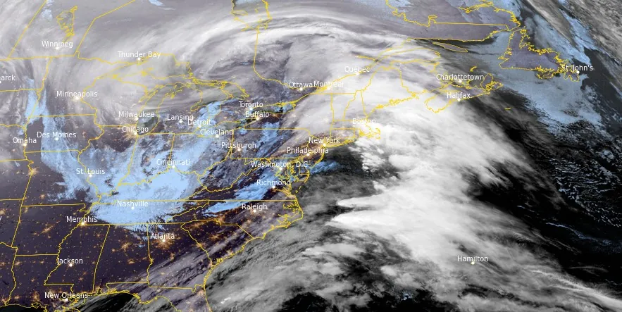
Image credit: NOAA/GOES-East, RAMMB/CIRA, The Watchers. Acquired at 09:00 UTC on January 13, 2024
A potent, fast-moving storm is expected to bring historical coastal flooding to Maine on Saturday morning (LT), January 13, 2024. The state is bracing for a combination of major coastal flooding, strong winds, heavy rainfall, and snow in mountainous regions, predominantly during the morning. The most severe rain and wind conditions are forecasted between 06:00 and 10:00 LT, with the most critical coastal flooding anticipated around noon LT, coinciding with the high tide.
This storm follows just four days after another system caused street flooding and structural damage.
“Potential historic coastal water levels tomorrow [January 13],” the National Weather Service (NWS) office in Gray said on X. “Expect water in areas you have never seen before along the Gulf of Maine coastline.”
A Coastal Flood Warning is in effect from 09:00 to 15:00 LT, January 13 for Maine, Coastal York, Coastal Cumberland, Sagadahoc, Lincoln, Knox, and Coastal Waldo Counties. In New Hampshire, Coastal Rockingham County.
Another messy system moves in Friday night through Saturday. Here is one model's depiction of the timing and precipitation types. For the latest winter precipitation forecast maps visit https://t.co/gFImdBEIKd pic.twitter.com/V3k7jUc8AE
— NWS Gray (@NWSGray) January 11, 2024
Very high water levels, perhaps record-breaking in some locations, are expected to result in widespread moderate to major coastal flooding. The peak storm surge is expected to reach 0.9 – 1 m (3 – 3.5 feet” around noontime. The forecast crest in Portland of 4.29 m (14.1 feet) would approach the all-time record of 4.32 m (14.17 feet) set in the blizzard of 1978.
There is a significant threat to property, NWS said. Many coastal communities will experience damage. Numerous structures will flood with inundation water depth of up to 0.9 m (3 feet) resulting in damage to vulnerable homes and businesses near the waterfront. Numerous road closures are expected.
A few locations could become isolated due to the flooding of roads. Vehicles parked in vulnerable areas near the waterfront will likely become flooded. A few evacuations may be needed in the most vulnerable areas.
NWS is urging residents living in affected areas to take the necessary actions to protect flood-prone property. If travel is required, do not drive around barricades or through water of unknown depth.
Wind Advisory remains in effect until 16:00 LT today for Maine, Lincoln, Sagadahoc, Coastal Cumberland, and Coastal York Counties. In New Hampshire, Coastal Rockingham County.
Wind gusts could reach speeds of up to 90 km/h (55 mph) along the coast, potentially causing isolated power outages, though widespread major power issues are not anticipated.
After the storm’s departure, Maine is set for a calmer Sunday, January 14, with a mix of sun and clouds, breezy conditions, and possible snow showers or flurries. Temperatures are expected to hover around 1 – 2 °C (34 – 36 °F).
References:
1 Coastal Hazard Message – National Weather Service Gray ME – 319 AM EST Sat Jan 13 2024
I'm a dedicated researcher, journalist, and editor at The Watchers. With over 20 years of experience in the media industry, I specialize in hard science news, focusing on extreme weather, seismic and volcanic activity, space weather, and astronomy, including near-Earth objects and planetary defense strategies. You can reach me at teo /at/ watchers.news.
Commenting rules and guidelines
We value the thoughts and opinions of our readers and welcome healthy discussions on our website. In order to maintain a respectful and positive community, we ask that all commenters follow these rules.