
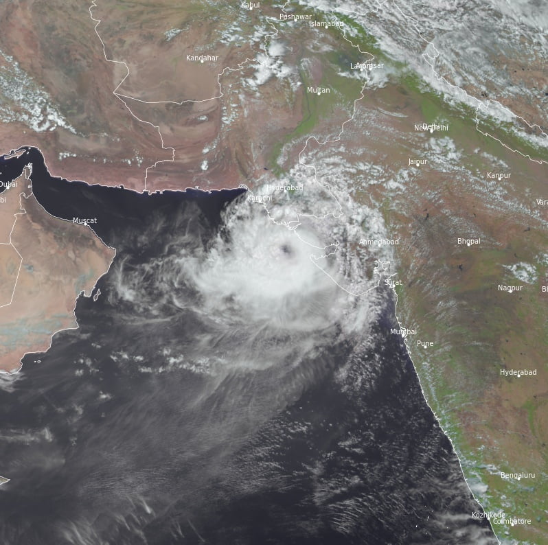
Very Severe Cyclonic Storm “Biparjoy” making landfall near Jakhau port, Gujarat, India
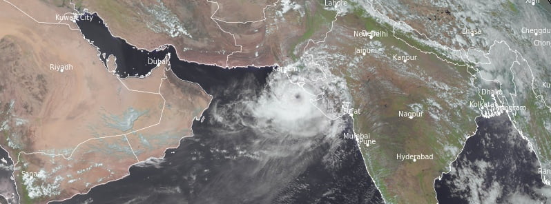
Featured image: Tropical Cyclone "Biparjoy" at 09:30 UTC on June 15, 2023. Credit: EUMETSAT/Meteosat-9, RAMMB/CIRA, The Watchers
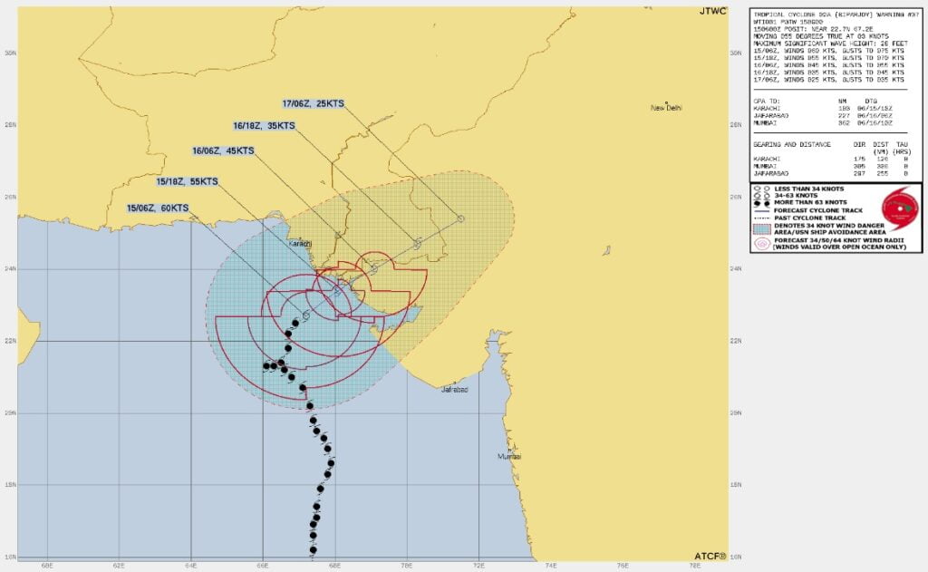
Biparjoy is making landfall along the coast of Saurashtra and Kutch, India and adjoining Pakistan — between Mandvi, Gujarat, and Karachi, Pakistan near Jakhau port, Gujarat — on June 15, 2023, with a maximum sustained wind speed of 115 to 125 km /h (71 – 78 mph), with gusts to 140 km/h (87 mph).
The landfall process commenced at around 13:00 UTC and will last for a couple of hours.
Biparjoy has already claimed the lives of 7 people and forced the evacuation of more than 170 000 people — around 94 000 in India and 84 000 in Pakistan.
At 11:00 UTC, the center of Biparjoy was located about 110 km (68 miles) WSW of Jakhau port, Gujarat, 140 km (87 miles) WSW of Naliya, Pakistan, and 160 km (100 miles) WNW of Devbhumi Dwarka, Gujarat, India.
The cyclone had maximum sustained winds of 120 to 130 km/h (74 – 80 mph) with gusts to 145 km/h (90 mph).
Rainfall forecast
On June 15, expect light to moderate rainfall in most regions, with heavy to very heavy rainfall in a few places and extremely heavy downpours in isolated areas over Kachchh, Devbhumi Dwarka and Jamnagar. Similarly, heavy to very heavy rainfall is predicted for a few places in the Porbandar, Rajkot, Morbi and Junagarh districts of Gujarat. The remaining districts of Saurashtra and the north Gujarat region may see isolated heavy to very heavy rainfall.
On June 16 and 17, light to moderate rainfall with heavy to extremely heavy rainfall in isolated places is likely over north Gujarat, adjoining south Rajasthan, southeast Rajasthan and the adjoining North Gujarat region.
Wind warning
The northeast Arabian Sea is expected to have gale winds reaching 120 – 130 km/h (74.5 – 80.8 mph) gusting to 150 km/h (93.2 mph), decreasing to 115 -1 25 km/h (71.5 – 77.7 mph) gusting to 140 km/h (87 mph) by the evening of June 15 (LT). By the morning of June 16, expect squally winds with speeds reaching 50 – 60 km/h (31 – 37.3 mph) gusting to 70 km/h (43.5 mph).
In the east-central Arabian Sea, gale winds are already reaching 50 – 60 km/h (31 – 37.3 mph) gusting to 70 km/h (43.5 mph), and are expected to become squally with speeds reaching 40 – 50 km/h (24.9 – 31 mph) gusting to 60 km/h (37.3 mph) from the evening of June 15 (LT) for the subsequent 12 hours.
Along and off the coasts of Saurashtra and Kutch (Kachchh, Devbhumi Dwarka, Porbandar, Jamnagar, Rajkot, Junagarh and Morbi districts), gale winds reaching 70 – 80 km/h (43.5 – 49.7 mph) gusting to 90 km/h (55.9 mph) are expected to increase, reaching 115 – 125 km/h (71.5 – 77.7 mph) gusting to 135 km/h (83.9 mph) from the afternoon of June 15 to the night.
In South Rajasthan, expect squally wind speeds of 40 – 50 km/h (24.9 – 31 mph) gusting to 60 km/h (37.3 mph) from the afternoon to evening of June 16, and 35 – 45 km/h (21.7 – 28 mph) gusting to 55 km/h (34.2 mph) until midnight of June 17.
Sea condition warning
Sea conditions are expected to be extremely rough over the northeast Arabian Sea and the adjoining east central Arabian Sea until the evening of June 15.
Along and off the coasts of Saurashtra and Kutch, expect very high to extreme sea conditions until the night of June 15.
Storm surge warning
A storm surge of about 2 -3 m (6.6 – 9.8 feet) above the astronomical tide is predicted to inundate the low-lying areas of Kachchh, Devbhumi Dwarka, Porbandar, Jamnagar and Morbi districts during the time of landfall.
Potential damages on June 15
Anticipate total destruction of thatched houses and extensive damage to kutcha houses with some damage to Pucca houses in the Kachchh, Devbhumi Dwarka, Porbandar, Jamnagar, Morbi and Junagarh, and Rajkot districts of Gujarat.
There’s a potential threat from flying objects and significant damage to roads, railways, power and communication infrastructure. Widespread damage to crops, plantations, and orchards is also expected.
Fishermen warning
All fishing operations over the northeast and adjoining east central Arabian Sea should be suspended until June 15. Those currently out at sea should return to the coast.
References:
1 Very Severe Cyclonic Storm “Biparjoy” – Bulletin no. 75 (ARB/01/2023) – RSCM New Delhi – 12:30 UTC on June 15, 2023
The Watchers team and our contributors bring the latest on extreme weather, earthquakes, volcanic eruptions, space weather, and all things science. We're all about making sense of the natural world and keeping you informed on what’s happening. Got a tip or a question? Hit us up using the form at newstips!
Commenting rules and guidelines
We value the thoughts and opinions of our readers and welcome healthy discussions on our website. In order to maintain a respectful and positive community, we ask that all commenters follow these rules.