
Major Nor’easter triggers snow, wind, and disruptions in northeastern U.S.
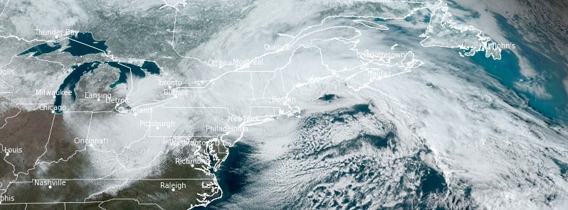
Featured image: Major Nor'easter affecting the northeastern U.S. Credit: NOAA/GOES-East, RAMMB/CIRA, The Watchers. Acquired at 20:00 UTC on March 14, 2023
A powerful Nor’easter is wreaking havoc across parts of the northeastern United States, with heavy snowfall, strong winds, and coastal flooding leading to travel disruptions and widespread power outages. The storm is expected to impact the region from northeast Pennsylvania to southern Maine through tonight.
As of 22:00 UTC, approximately 590 000 people have been left without power. Snowfall in some areas of the Northeast has exceeded 60 cm (23 inches), with Windsor, Massachusetts reporting 71 cm (28 inches) of snow by Tuesday afternoon (LT). In Vermont, Readsboro recorded 62 cm (24.5 inches) of snow, while Palenville, New York saw at least 46 cm (18 inches) of snow.
Over 800 flights have been canceled and more than 650 delayed across the region, according to FlightAware. Boston Logan International Airport alone saw nearly 300 cancellations, with 25% of all flights being affected due to the worsening weather conditions.
Thundersnow was reported in several locations in western Massachusetts on Tuesday morning, with lightning illuminating the sky in Westfield and Agawam. The storm has also forced over 70 towns in New Hampshire to postpone scheduled elections, with many communities rescheduling them for March 28.
The Nor’easter is expected to continue producing gusty winds and periods of heavy snow throughout New England until Wednesday, March 15.
Additional snowfall of 15 to 30 cm (6 to 12 inches) is possible in parts of Vermont, northern New Hampshire, and northern Maine.
The storm has already caused power outages and tree damage due to the weight of the snow, and gusty winds reaching up to 60 mph (97 km/h) along the coast and 40 mph (64 km/h) inland could exacerbate these issues.
The low-pressure system is forecast to peak in intensity near Cape Cod this evening (LT) before gradually moving eastward into the Atlantic Ocean on Wednesday.
Cold temperatures have spread into the Mid-South and Southeast, with low temperatures expected to dip near or below freezing on Wednesday morning, potentially causing damage to vegetation and unprotected plumbing.
Meanwhile, California is grappling with the effects of a second atmospheric river in just one week, as heavy rainfall and high-elevation snow continue to pummel the state. The National Weather Service (NWS) has warned of a high risk for excessive rainfall today, with the storm expected to persist into Wednesday, further exacerbating the potential for widespread flooding.
At 21:00 UTC on March 14, around 380 000 customers — or about 950 000 people — in California are without power.
The next major storm system is anticipated to develop across the central U.S. on Thursday, with winter weather impacts expected in the Upper Midwest and Great Lakes region. Farther south, the potential for severe thunderstorms exists from the southern Plains to the Lower Mississippi Valley.
References:
1 LIVE: 1st significant nor’easter of season unleashes heavy snow, causes travel issues – AccuWeather – March 14, 2023
2 Short Range Forecast Discussion – NWS Weather Prediction Center College Park MD – 346 PM EDT Tue Mar 14 2023
3 Almost 1 million Californians without power amid second atmospheric river impact in a week – The Watchers – March 14, 2023
I'm a dedicated researcher, journalist, and editor at The Watchers. With over 20 years of experience in the media industry, I specialize in hard science news, focusing on extreme weather, seismic and volcanic activity, space weather, and astronomy, including near-Earth objects and planetary defense strategies. You can reach me at teo /at/ watchers.news.
Commenting rules and guidelines
We value the thoughts and opinions of our readers and welcome healthy discussions on our website. In order to maintain a respectful and positive community, we ask that all commenters follow these rules.