
Rare January disturbance/subtropical storm forms in the NW Atlantic Ocean
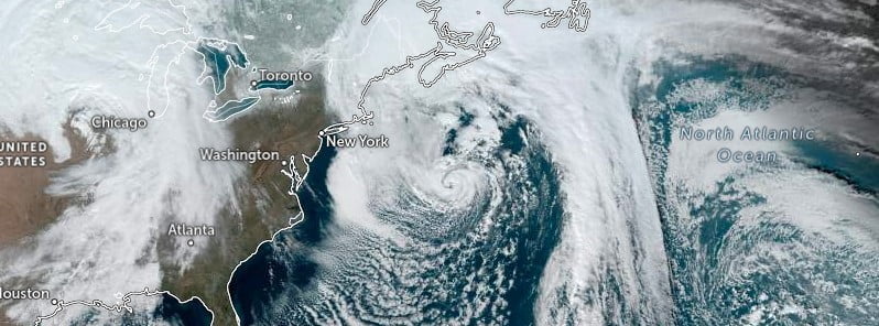
Featured image: Invest 90L at 18:50 UTC on January 16, 2023. Credit: NOAA/GOES-East, Zoom Earth, The Watchers
A rare January disturbance/subtropical storm formed in the NW Atlantic Ocean on January 16, 2023. The system was designated by the NHC as Invest 90L.
Many meteorologists noted that the system was a subtropical cyclone while others compared it to the 1991 Perfect Storm and a 2013 unnamed subtropical storm for the precedent that a system that is a subtropical storm is not operationally classified as such.
“This hybrid system is a candidate to add to the historical database after the fact as a subtropical storm,” said Rick Knabb — the former director of the NWS National Hurricane Center and currently Hurricane Expert at The Weather Channel.
“There’s operational discretion on handling such systems in real-time but it’s borderline non-frontal, weak shear inside a cutoff low, and powered in part by relatively warm Gulf Stream.”
“A non-tropical low pressure system is centered over the northwestern Atlantic Ocean about 480 km (300 miles) north of Bermuda is producing storm-force winds,” the NWS National Hurricane Center Miami in Florida said in the Special Tropical Weather Outlook issued at 15:00 UTC on January 16.
“Although the cyclone is producing some thunderstorm activity near the center, it is embedded in a cold air mass with nearby frontal boundaries. The low is expected to move northeastward today and northward tonight, bringing the system over much colder waters and across Atlantic Canada by early Tuesday. Therefore, it is unlikely that the low will transition to a subtropical or tropical cyclone. Nevertheless, the system is expected to remain a strong non-tropical low during the next day or so.”

No additional Special Tropical Weather Outlooks are scheduled for this system, NHC said.
“Regularly scheduled Tropical Weather Outlooks will resume on May 15, 2023, while Special Tropical Weather Outlooks will be issued as necessary during the off-season.”
The formation chance for this system through the next 2 and 5 days is low…near 0 percent, according to the NHC.
I'm a dedicated researcher, journalist, and editor at The Watchers. With over 20 years of experience in the media industry, I specialize in hard science news, focusing on extreme weather, seismic and volcanic activity, space weather, and astronomy, including near-Earth objects and planetary defense strategies. You can reach me at teo /at/ watchers.news.
Commenting rules and guidelines
We value the thoughts and opinions of our readers and welcome healthy discussions on our website. In order to maintain a respectful and positive community, we ask that all commenters follow these rules.